You are here: Home > Network List > TA - USArray Transportable Network (new EarthScope stations) Stations List
> Station A11A Hall Mountain, Copeland, ID, USA > Earthquake Result Viewer
A11A Hall Mountain, Copeland, ID, USA - Earthquake Result Viewer
| Earthquake location: |
Tonga Islands |
| Earthquake latitude/longitude: |
-17.5/-174.3 |
| Earthquake time(UTC): |
2007/08/26 (238) 12:37:31 GMT |
| Earthquake Depth: |
127 km |
| Earthquake Magnitude: |
5.9 MB, 6.1 MW |
| Earthquake Catalog/Contributor: |
WHDF/NEIC |
|
| Network: |
TA USArray Transportable Network (new EarthScope stations) |
| Station: |
A11A Hall Mountain, Copeland, ID, USA |
| Lat/Lon: |
48.96 N/116.36 W |
| Elevation: |
1455 m |
|
| Distance: |
83.7 deg |
| Az: |
34.206 deg |
| Baz: |
234.5 deg |
| Ray Param: |
0.045703676 |
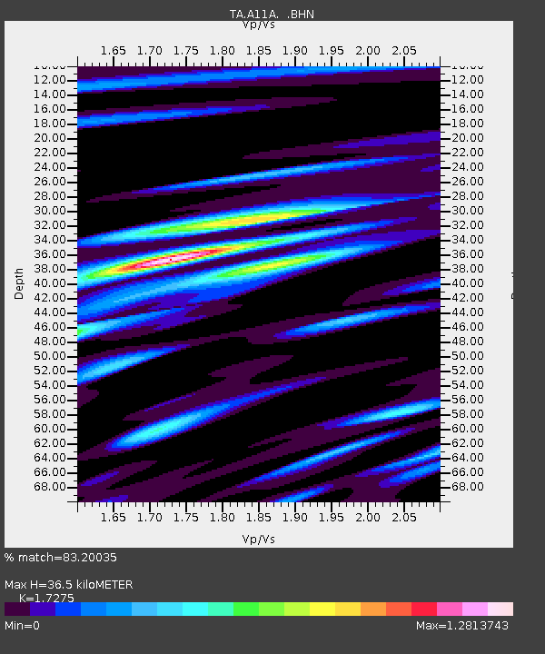
| Estimated Moho Depth: |
36.5 km |
| Estimated Crust Vp/Vs: |
1.73 |
| Assumed Crust Vp: |
6.571 km/s |
| Estimated Crust Vs: |
3.804 km/s |
| Estimated Crust Poisson's Ratio: |
0.25 |
|
| Radial Match: |
83.20035 % |
| Radial Bump: |
400 |
| Transverse Match: |
80.15005 % |
| Transverse Bump: |
400 |
| SOD ConfigId: |
2564 |
| Insert Time: |
2010-03-07 04:29:36.456 +0000 |
| GWidth: |
2.5 |
| Max Bumps: |
400 |
| Tol: |
0.001 |
|
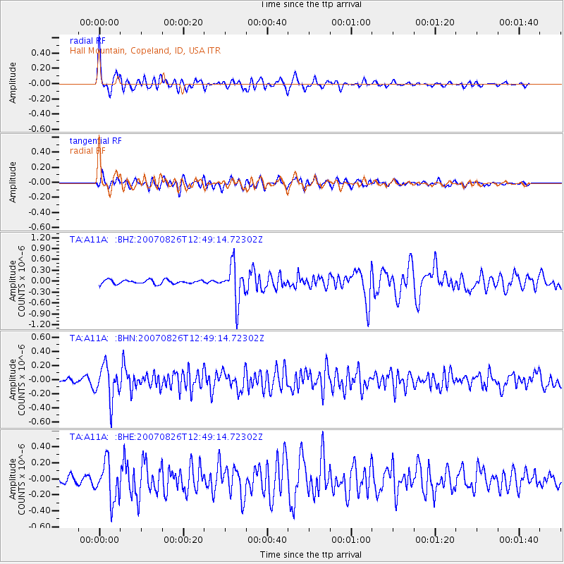
Signal To Noise
| Channel | StoN | STA | LTA |
| TA:A11A: :BHN:20070826T12:49:14.72302Z | 7.3264275 | 2.463663E-7 | 3.362707E-8 |
| TA:A11A: :BHE:20070826T12:49:14.72302Z | 4.1912766 | 2.4201657E-7 | 5.7742927E-8 |
| TA:A11A: :BHZ:20070826T12:49:14.72302Z | 9.443975 | 5.167112E-7 | 5.4713315E-8 |
| Arrivals |
| Ps | 4.2 SECOND |
| PpPs | 15 SECOND |
| PsPs/PpSs | 19 SECOND |


