You are here: Home > Network List > TA - USArray Transportable Network (new EarthScope stations) Stations List
> Station A11A Hall Mountain, Copeland, ID, USA > Earthquake Result Viewer
A11A Hall Mountain, Copeland, ID, USA - Earthquake Result Viewer
| Earthquake location: |
Andreanof Islands, Aleutian Is. |
| Earthquake latitude/longitude: |
50.2/-177.6 |
| Earthquake time(UTC): |
2007/08/16 (228) 04:03:03 GMT |
| Earthquake Depth: |
15 km |
| Earthquake Magnitude: |
5.8 MB |
| Earthquake Catalog/Contributor: |
WHDF/NEIC |
|
| Network: |
TA USArray Transportable Network (new EarthScope stations) |
| Station: |
A11A Hall Mountain, Copeland, ID, USA |
| Lat/Lon: |
48.96 N/116.36 W |
| Elevation: |
1455 m |
|
| Distance: |
38.7 deg |
| Az: |
67.482 deg |
| Baz: |
295.859 deg |
| Ray Param: |
0.07539696 |
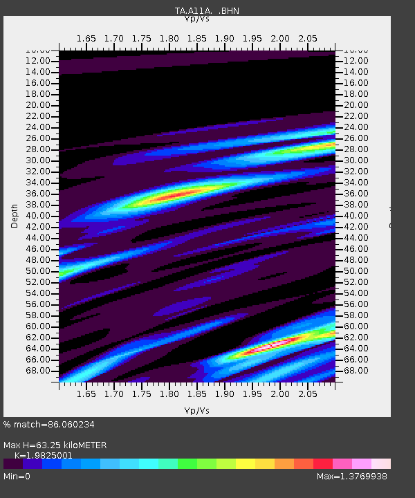
| Estimated Moho Depth: |
63.25 km |
| Estimated Crust Vp/Vs: |
1.98 |
| Assumed Crust Vp: |
6.571 km/s |
| Estimated Crust Vs: |
3.314 km/s |
| Estimated Crust Poisson's Ratio: |
0.33 |
|
| Radial Match: |
86.060234 % |
| Radial Bump: |
357 |
| Transverse Match: |
73.96878 % |
| Transverse Bump: |
372 |
| SOD ConfigId: |
2564 |
| Insert Time: |
2010-03-07 04:29:44.788 +0000 |
| GWidth: |
2.5 |
| Max Bumps: |
400 |
| Tol: |
0.001 |
|

Signal To Noise
| Channel | StoN | STA | LTA |
| TA:A11A: :BHN:20070816T04:09:55.950012Z | 3.1577969 | 5.3504795E-7 | 1.694371E-7 |
| TA:A11A: :BHE:20070816T04:09:55.950012Z | 3.1850321 | 7.661109E-7 | 2.4053475E-7 |
| TA:A11A: :BHZ:20070816T04:09:55.950012Z | 7.252965 | 1.2890366E-6 | 1.7772548E-7 |
| Arrivals |
| Ps | 10 SECOND |
| PpPs | 27 SECOND |
| PsPs/PpSs | 37 SECOND |


