You are here: Home > Network List > TA - USArray Transportable Network (new EarthScope stations) Stations List
> Station A11A Hall Mountain, Copeland, ID, USA > Earthquake Result Viewer
A11A Hall Mountain, Copeland, ID, USA - Earthquake Result Viewer
| Earthquake location: |
Vanuatu Islands |
| Earthquake latitude/longitude: |
-15.6/167.7 |
| Earthquake time(UTC): |
2007/08/01 (213) 17:08:51 GMT |
| Earthquake Depth: |
120 km |
| Earthquake Magnitude: |
6.2 MB, 7.2 MW, 7.2 MW |
| Earthquake Catalog/Contributor: |
WHDF/NEIC |
|
| Network: |
TA USArray Transportable Network (new EarthScope stations) |
| Station: |
A11A Hall Mountain, Copeland, ID, USA |
| Lat/Lon: |
48.96 N/116.36 W |
| Elevation: |
1455 m |
|
| Distance: |
92.7 deg |
| Az: |
39.801 deg |
| Baz: |
249.37 deg |
| Ray Param: |
0.04134354 |
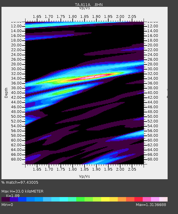
| Estimated Moho Depth: |
33.0 km |
| Estimated Crust Vp/Vs: |
1.89 |
| Assumed Crust Vp: |
6.571 km/s |
| Estimated Crust Vs: |
3.477 km/s |
| Estimated Crust Poisson's Ratio: |
0.31 |
|
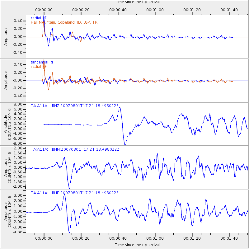
| Radial Match: |
97.43005 % |
| Radial Bump: |
382 |
| Transverse Match: |
88.25995 % |
| Transverse Bump: |
400 |
| SOD ConfigId: |
2564 |
| Insert Time: |
2010-03-07 04:29:52.642 +0000 |
| GWidth: |
2.5 |
| Max Bumps: |
400 |
| Tol: |
0.001 |
|
Signal To Noise
| Channel | StoN | STA | LTA |
| TA:A11A: :BHN:20070801T17:21:18.498022Z | 2.663917 | 9.7204975E-8 | 3.6489492E-8 |
| TA:A11A: :BHE:20070801T17:21:18.498022Z | 3.0870984 | 1.5593615E-7 | 5.0512206E-8 |
| TA:A11A: :BHZ:20070801T17:21:18.498022Z | 5.3125815 | 4.46231E-7 | 8.399514E-8 |
| Arrivals |
| Ps | 4.6 SECOND |
| PpPs | 14 SECOND |
| PsPs/PpSs | 19 SECOND |


