You are here: Home > Network List > TA - USArray Transportable Network (new EarthScope stations) Stations List
> Station A11A Hall Mountain, Copeland, ID, USA > Earthquake Result Viewer
A11A Hall Mountain, Copeland, ID, USA - Earthquake Result Viewer
| Earthquake location: |
Gulf Of Mexico |
| Earthquake latitude/longitude: |
21.9/-96.4 |
| Earthquake time(UTC): |
2007/05/23 (143) 19:09:15 GMT |
| Earthquake Depth: |
10 km |
| Earthquake Magnitude: |
5.6 MW, 4.8 MS, 5.4 MB |
| Earthquake Catalog/Contributor: |
WHDF/NEIC |
|
| Network: |
TA USArray Transportable Network (new EarthScope stations) |
| Station: |
A11A Hall Mountain, Copeland, ID, USA |
| Lat/Lon: |
48.96 N/116.36 W |
| Elevation: |
1455 m |
|
| Distance: |
31.3 deg |
| Az: |
334.317 deg |
| Baz: |
142.361 deg |
| Ray Param: |
0.0790926 |
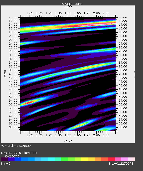
| Estimated Moho Depth: |
13.25 km |
| Estimated Crust Vp/Vs: |
2.08 |
| Assumed Crust Vp: |
6.571 km/s |
| Estimated Crust Vs: |
3.163 km/s |
| Estimated Crust Poisson's Ratio: |
0.35 |
|
| Radial Match: |
84.36639 % |
| Radial Bump: |
400 |
| Transverse Match: |
78.01619 % |
| Transverse Bump: |
400 |
| SOD ConfigId: |
2564 |
| Insert Time: |
2010-03-07 04:30:12.589 +0000 |
| GWidth: |
2.5 |
| Max Bumps: |
400 |
| Tol: |
0.001 |
|
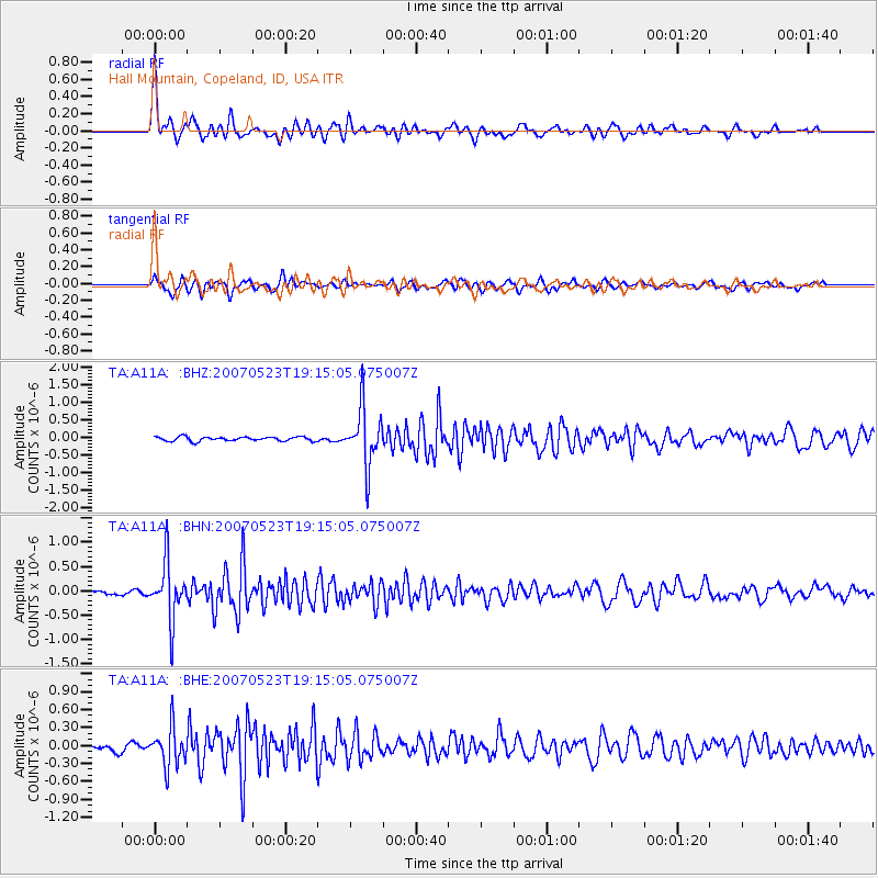
Signal To Noise
| Channel | StoN | STA | LTA |
| TA:A11A: :BHN:20070523T19:15:05.075007Z | 12.730734 | 5.774008E-7 | 4.535487E-8 |
| TA:A11A: :BHE:20070523T19:15:05.075007Z | 5.5933924 | 3.1895408E-7 | 5.7023367E-8 |
| TA:A11A: :BHZ:20070523T19:15:05.075007Z | 13.55392 | 8.2465135E-7 | 6.0842275E-8 |
| Arrivals |
| Ps | 2.3 SECOND |
| PpPs | 5.8 SECOND |
| PsPs/PpSs | 8.1 SECOND |


