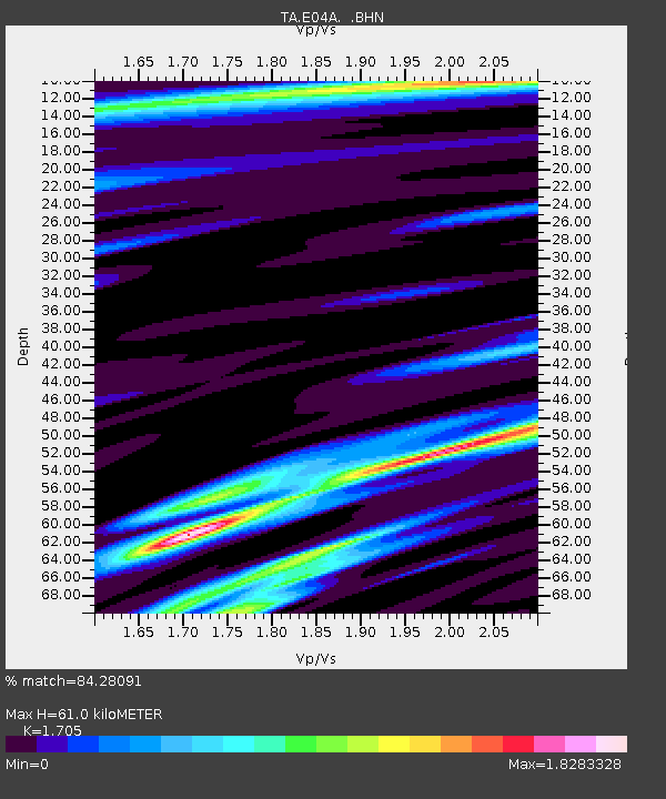
E04A Onalaska, WA, USA - Earthquake Result Viewer
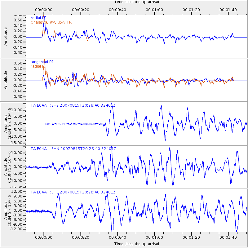
Earthquake location: Andreanof Islands, Aleutian Is.
Earthquake latitude/longitude: 50.3/-177.5
Earthquake time(UTC): 2007/08/15 (227) 20:22:11 GMT
Earthquake Depth: 9.0 km
Earthquake Magnitude: 6.3 MB, 6.2 MS, 6.4 MW, 5.9 ML
Earthquake Catalog/Contributor: WHDF/NEIC
Network: TA USArray Transportable Network (new EarthScope stations)
Station: E04A Onalaska, WA, USA
Lat/Lon: 46.59 N/122.72 W
Elevation: 215 m
Distance: 35.9 deg
Az: 74.218 deg
Baz: 296.556 deg
Ray Param: 0.076999
Estimated Moho Depth: 61.0 km
Estimated Crust Vp/Vs: 1.71
Assumed Crust Vp: 6.566 km/s
Estimated Crust Vs: 3.851 km/s
Estimated Crust Poisson's Ratio: 0.24
Radial Match: 84.28091 %
Radial Bump: 400
Transverse Match: 80.412285 %
Transverse Bump: 400
SOD ConfigId: 2564
Insert Time: 2010-03-07 04:40:04.977 +0000
GWidth: 2.5
Max Bumps: 400
Tol: 0.001

Signal To Noise

ChannelStoNSTALTA
TA:E04A: :BHN:20070815T20:28:40.32401Z2.68085816.521213E-72.4325095E-7
TA:E04A: :BHE:20070815T20:28:40.32401Z2.80814486.702883E-72.3869433E-7
TA:E04A: :BHZ:20070815T20:28:40.32401Z20.6774393.1236837E-61.5106724E-7
Arrivals
Ps7.1 SECOND
PpPs23 SECOND
PsPs/PpSs30 SECOND