
Station TA E04A - Onalaska, WA, USA
Network: TA - USArray Transportable Network (new EarthScope stations)
Nearby stations (2 deg radius)
| Station | Name | (Lat, Lon) | Start / End | Elevation |
| E04A | Onalaska, WA, USA | (46.59, -122.72) | 2005-10-27 / 2499-01-01 | 0.2 km |
| Crust2 Type: | L8,thin continental arc, Cordilleras, 0.5 km seds. |
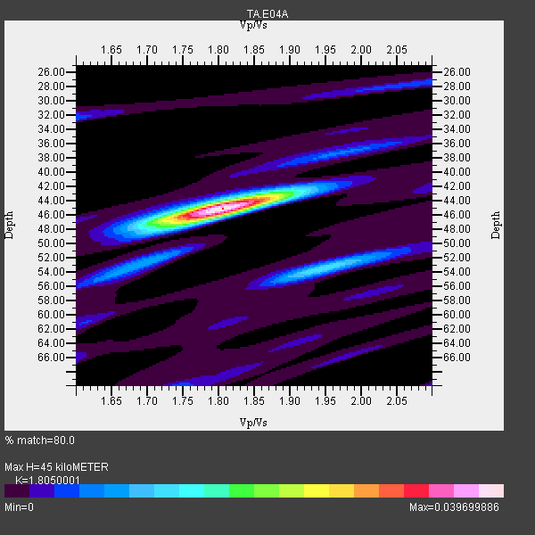
| Thickness Estimate: | 45 km |
| Thickness StdDev: | 1.8 km |
| Vp/Vs Estimate: | 1.81 |
| Vp/Vs StdDev: | 0.04 |
| Vs Estimate: | 3.638 km/s |
| Poisson's Ratio: | 0.28 |
| Peak Value: | 0.04 |
| Assumed Vp: | 6.566 km/s |
| Ps Weight: | 0.33333334 |
| PpPs Weight: | 0.33333334 |
| PsPs Weight: | 0.33333328 |
| Residual Complexity: | 0.330 |
| Nearby stations H: | +- |
| (2.0 deg) Vp/Vs: | +- |
4 with match > 90% ( 23.529411 %) and 17 with match > 80% ( 100.0 %) out of 17.
Download stack as xyz text file.
Azimuth Distribution of Events:

Prior Results for this Station
| Study | Thickness | Vp/Vs | Vp | Vs | Poissons Ratio | Extra |
| EARS | 45 km | 1.81 | 6.566 km/s | 3.638 km/s | 0.28 | |
| Crust2.0 | 34 km | 1.77 | 6.566 km/s | 3.707 km/s | 0.27 | L8,thin continental arc, Cordilleras, 0.5 km seds. |
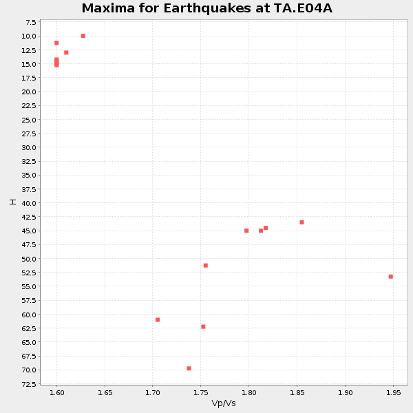
| Global Maxima | 45 km | 1.81 | 6.566 km/s | 3.638 km/s | 0.28 | amp=0.039699886 |
| Local Maxima 1 | 54 km | 1.94 | 6.566 km/s | 3.385 km/s | 0.32 | amp=0.01330547 |
| Local Maxima 2 | 47 km | 1.75 | 6.566 km/s | 3.741 km/s | 0.26 | amp=0.009290318 |
| Local Maxima 3 | 44 km | 1.82 | 6.566 km/s | 3.618 km/s | 0.28 | amp=0.007027786 |
| Local Maxima 4 | 27 km | 2.10 | 6.566 km/s | 3.13 km/s | 0.35 | amp=0.0056717903 |
| Predicted Arrivals for vertical incidence (zero ray parameter) | |
| Ps | 5.52 SECOND |
| PpPs | 19.22 SECOND |
| PsPs/PpSs | 24.74 SECOND |
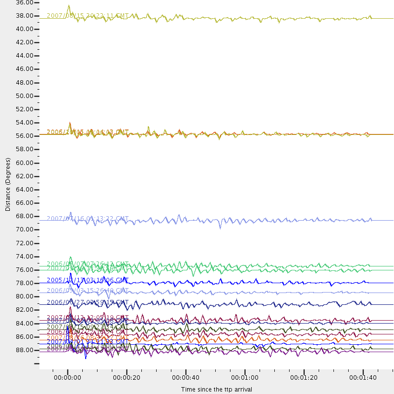
Events Processed for this Station
Download zip of receiver functions as SAC
Plot maxima for each earthquake.
Events Used in the Stack
(17 events)| Radial Match | Distance | Baz | FERegion | Time | Lat/Lon | Depth | Magnitude |
| 94.67109 | 89.5 deg | 258.882 deg | Solomon Islands | 2007/04/01 21:11:33 GMT | (-7.3, 155.7) | 10 km | 6.3 MB |
| 92.676506 | 81.0 deg | 228.003 deg | Tonga Islands | 2006/05/03 15:26:40 GMT | (-20.2, -174.1) | 55 km | 7.2 MB, 7.8 MS, 7.9 MW, 7.9 MW |
| 91.56136 | 86.0 deg | 248.672 deg | Santa Cruz Islands | 2007/09/02 01:05:18 GMT | (-11.6, 165.8) | 35 km | 5.9 MB, 7.3 MS, 7.2 MW, 6.9 ME |
| 91.537964 | 88.8 deg | 254.473 deg | Solomon Islands | 2007/08/16 08:39:27 GMT | (-9.8, 159.5) | 10 km | 6.1 MB, 6.7 MS, 6.4 MW |
| 89.28299 | 76.7 deg | 230.33 deg | Tonga Islands | 2006/07/07 07:26:12 GMT | (-15.2, -173.6) | 35 km | 5.7 MB, 5.9 MS, 6.0 MW, 6.0 MW |
| 88.377014 | 79.4 deg | 234.355 deg | Fiji Islands Region | 2005/12/13 03:16:06 GMT | (-15.3, -178.6) | 10 km | 6.1 MB, 6.8 MS, 6.7 MW, 6.7 MW |
| 87.97165 | 87.1 deg | 244.131 deg | Vanuatu Islands | 2007/07/15 09:27:34 GMT | (-15.4, 168.6) | 8.0 km | 6.0 MB, 5.8 MS, 6.1 MW, 6.0 MW |
| 87.732704 | 55.0 deg | 303.112 deg | Kuril Islands | 2006/11/15 11:14:13 GMT | (46.6, 153.3) | 10 km | 6.5 MB, 7.8 MS, 8.3 MW, 7.9 MW |
| 87.08576 | 77.4 deg | 288.59 deg | Volcano Islands, Japan Region | 2007/09/28 13:38:59 GMT | (22.0, 142.7) | 276 km | 6.7 MB, 7.4 MW, 7.4 MW |
| 86.23718 | 90.7 deg | 259.236 deg | Solomon Islands | 2007/06/28 02:52:09 GMT | (-8.0, 154.6) | 10 km | 6.3 MB, 6.7 MS, 6.7 MW, 6.7 MW |
| 84.36094 | 69.2 deg | 302.828 deg | Near West Coast Of Honshu, Japan | 2007/07/16 01:13:22 GMT | (37.5, 138.4) | 12 km | 6.5 MB, 6.4 MS, 6.6 MW, 6.5 MW |
| 84.28091 | 35.9 deg | 296.556 deg | Andreanof Islands, Aleutian Is. | 2007/08/15 20:22:11 GMT | (50.3, -177.5) | 9.0 km | 6.3 MB, 6.2 MS, 6.4 MW, 5.9 ML |
| 83.815506 | 55.0 deg | 302.999 deg | Kuril Islands | 2006/10/01 09:06:02 GMT | (46.5, 153.2) | 19 km | 6.1 MB, 6.4 MS, 6.6 MW, 6.5 MW |
| 82.20223 | 85.5 deg | 248.444 deg | Santa Cruz Islands | 2007/08/12 12:05:19 GMT | (-11.4, 166.3) | 42 km | 5.8 MB, 5.7 MS, 6.0 MW, 6.0 MW |
| 81.576904 | 83.0 deg | 231.461 deg | Fiji Islands Region | 2006/06/27 02:59:15 GMT | (-19.9, -178.3) | 570 km | 6.0 MB, 6.2 MW |
| 81.0205 | 90.2 deg | 224.867 deg | Kermadec Islands Region | 2006/03/31 13:21:00 GMT | (-29.6, -176.8) | 17 km | 5.9 MB, 6.7 MS, 6.5 MW, 6.5 MW |
| 80.47775 | 87.9 deg | 244.467 deg | Vanuatu Islands | 2006/08/07 22:18:54 GMT | (-15.8, 167.8) | 141 km | 6.0 MB, 6.8 MW, 6.8 MW |
Losers
(0 events)| Radial Match | Distance | Baz | FERegion | Time | Lat/Lon | Depth | Magnitude | Reason |
