You are here: Home > Network List > TA - USArray Transportable Network (new EarthScope stations) Stations List
> Station E04A Onalaska, WA, USA > Earthquake Result Viewer
E04A Onalaska, WA, USA - Earthquake Result Viewer

| Earthquake location: |
Santa Cruz Islands |
| Earthquake latitude/longitude: |
-11.4/166.3 |
| Earthquake time(UTC): |
2007/08/12 (224) 12:05:19 GMT |
| Earthquake Depth: |
42 km |
| Earthquake Magnitude: |
5.8 MB, 5.7 MS, 6.0 MW, 6.0 MW |
| Earthquake Catalog/Contributor: |
WHDF/NEIC |
|
| Network: |
TA USArray Transportable Network (new EarthScope stations) |
| Station: |
E04A Onalaska, WA, USA |
| Lat/Lon: |
46.59 N/122.72 W |
| Elevation: |
215 m |
|
| Distance: |
85.5 deg |
| Az: |
40.848 deg |
| Baz: |
248.444 deg |
| Ray Param: |
0.044641946 |
| Estimated Moho Depth: |
62.25 km |
| Estimated Crust Vp/Vs: |
1.75 |
| Assumed Crust Vp: |
6.566 km/s |
| Estimated Crust Vs: |
3.747 km/s |
| Estimated Crust Poisson's Ratio: |
0.26 |
|
| Radial Match: |
82.20223 % |
| Radial Bump: |
396 |
| Transverse Match: |
74.20573 % |
| Transverse Bump: |
400 |
| SOD ConfigId: |
2564 |
| Insert Time: |
2010-03-07 04:40:06.794 +0000 |
| GWidth: |
2.5 |
| Max Bumps: |
400 |
| Tol: |
0.001 |
|
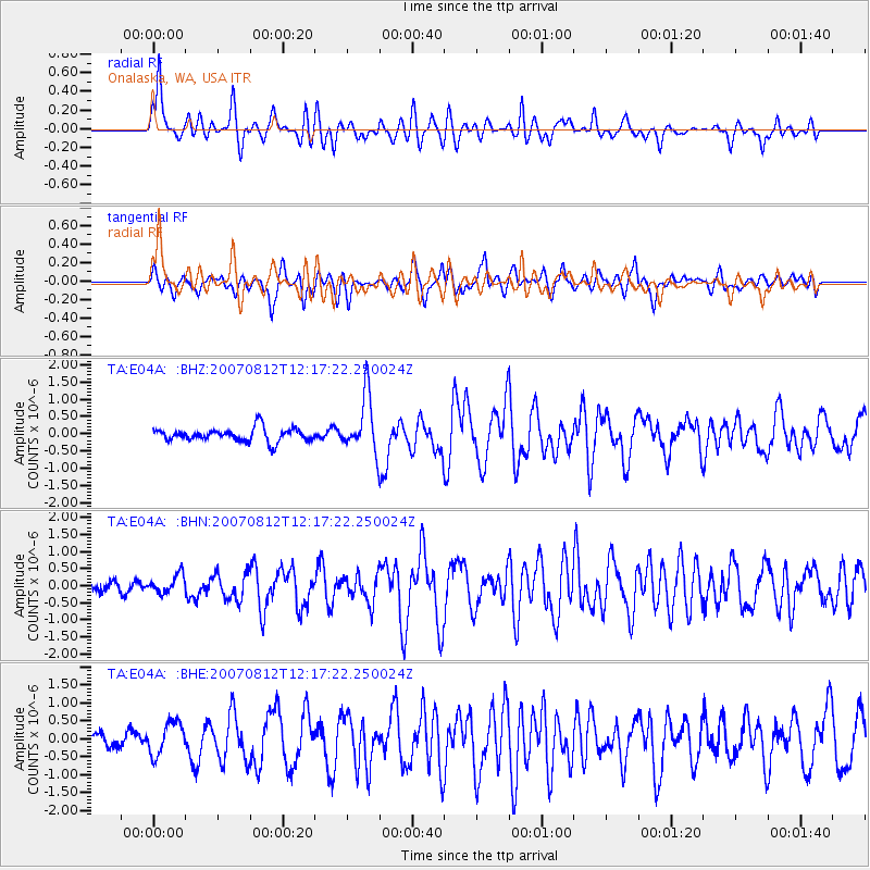
Signal To Noise
| Channel | StoN | STA | LTA |
| TA:E04A: :BHN:20070812T12:17:22.250024Z | 0.77902204 | 2.6914984E-7 | 3.4549709E-7 |
| TA:E04A: :BHE:20070812T12:17:22.250024Z | 1.4832574 | 4.5836043E-7 | 3.0902285E-7 |
| TA:E04A: :BHZ:20070812T12:17:22.250024Z | 4.266532 | 8.188952E-7 | 1.9193462E-7 |
| Arrivals |
| Ps | 7.3 SECOND |
| PpPs | 25 SECOND |
| PsPs/PpSs | 33 SECOND |


