You are here: Home > Network List > TA - USArray Transportable Network (new EarthScope stations) Stations List
> Station E04A Onalaska, WA, USA > Earthquake Result Viewer
E04A Onalaska, WA, USA - Earthquake Result Viewer
| Earthquake location: |
Volcano Islands, Japan Region |
| Earthquake latitude/longitude: |
22.0/142.7 |
| Earthquake time(UTC): |
2007/09/28 (271) 13:38:59 GMT |
| Earthquake Depth: |
276 km |
| Earthquake Magnitude: |
6.7 MB, 7.4 MW, 7.4 MW |
| Earthquake Catalog/Contributor: |
WHDF/NEIC |
|
| Network: |
TA USArray Transportable Network (new EarthScope stations) |
| Station: |
E04A Onalaska, WA, USA |
| Lat/Lon: |
46.59 N/122.72 W |
| Elevation: |
215 m |
|
| Distance: |
77.4 deg |
| Az: |
44.774 deg |
| Baz: |
288.59 deg |
| Ray Param: |
0.049602795 |
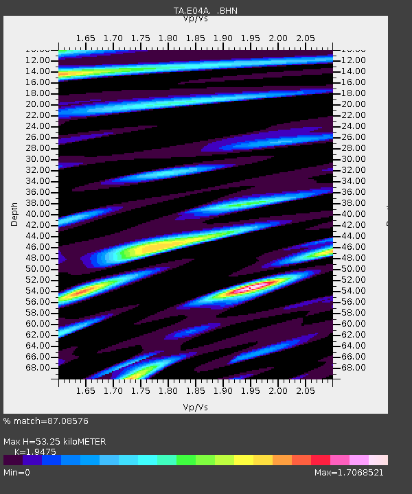
| Estimated Moho Depth: |
53.25 km |
| Estimated Crust Vp/Vs: |
1.95 |
| Assumed Crust Vp: |
6.566 km/s |
| Estimated Crust Vs: |
3.372 km/s |
| Estimated Crust Poisson's Ratio: |
0.32 |
|
| Radial Match: |
87.08576 % |
| Radial Bump: |
400 |
| Transverse Match: |
81.91117 % |
| Transverse Bump: |
400 |
| SOD ConfigId: |
2564 |
| Insert Time: |
2010-03-07 04:40:09.154 +0000 |
| GWidth: |
2.5 |
| Max Bumps: |
400 |
| Tol: |
0.001 |
|
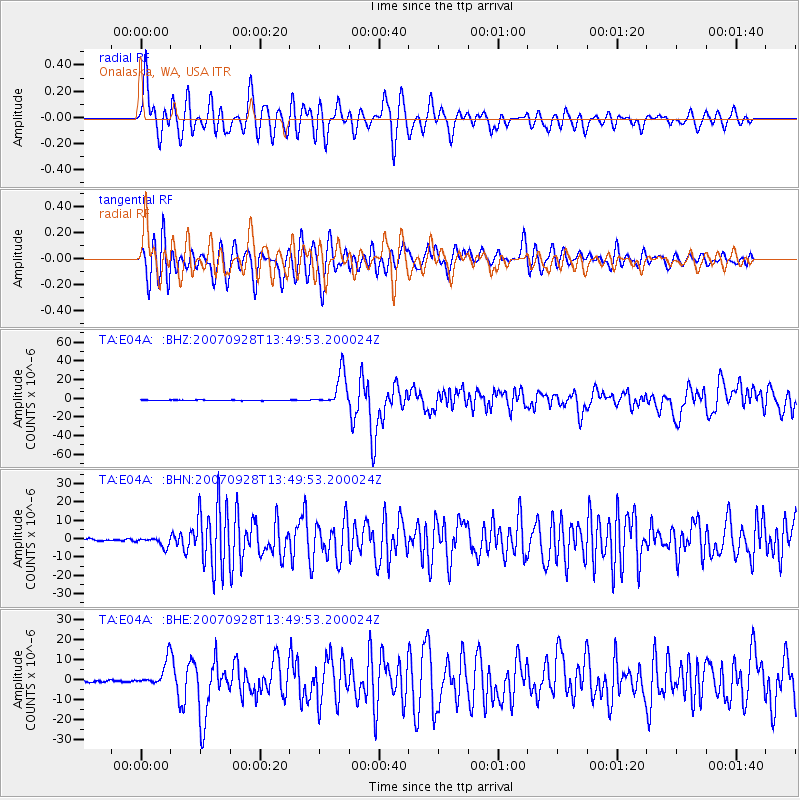
Signal To Noise
| Channel | StoN | STA | LTA |
| TA:E04A: :BHN:20070928T13:49:53.200024Z | 4.5352607 | 2.4517092E-6 | 5.4058836E-7 |
| TA:E04A: :BHE:20070928T13:49:53.200024Z | 11.559227 | 6.1638425E-6 | 5.3324004E-7 |
| TA:E04A: :BHZ:20070928T13:49:53.200024Z | 62.84333 | 1.8127523E-5 | 2.884558E-7 |
| Arrivals |
| Ps | 7.9 SECOND |
| PpPs | 23 SECOND |
| PsPs/PpSs | 31 SECOND |


