You are here: Home > Network List > TA - USArray Transportable Network (new EarthScope stations) Stations List
> Station E04A Onalaska, WA, USA > Earthquake Result Viewer
E04A Onalaska, WA, USA - Earthquake Result Viewer
| Earthquake location: |
Santa Cruz Islands |
| Earthquake latitude/longitude: |
-11.6/165.8 |
| Earthquake time(UTC): |
2007/09/02 (245) 01:05:18 GMT |
| Earthquake Depth: |
35 km |
| Earthquake Magnitude: |
5.9 MB, 7.3 MS, 7.2 MW, 6.9 ME |
| Earthquake Catalog/Contributor: |
WHDF/NEIC |
|
| Network: |
TA USArray Transportable Network (new EarthScope stations) |
| Station: |
E04A Onalaska, WA, USA |
| Lat/Lon: |
46.59 N/122.72 W |
| Elevation: |
215 m |
|
| Distance: |
86.0 deg |
| Az: |
40.966 deg |
| Baz: |
248.672 deg |
| Ray Param: |
0.04430189 |
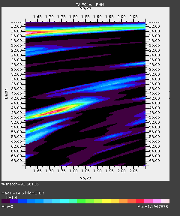
| Estimated Moho Depth: |
14.5 km |
| Estimated Crust Vp/Vs: |
1.60 |
| Assumed Crust Vp: |
6.566 km/s |
| Estimated Crust Vs: |
4.104 km/s |
| Estimated Crust Poisson's Ratio: |
0.18 |
|
| Radial Match: |
91.56136 % |
| Radial Bump: |
400 |
| Transverse Match: |
68.413704 % |
| Transverse Bump: |
400 |
| SOD ConfigId: |
2564 |
| Insert Time: |
2010-03-07 04:40:11.432 +0000 |
| GWidth: |
2.5 |
| Max Bumps: |
400 |
| Tol: |
0.001 |
|
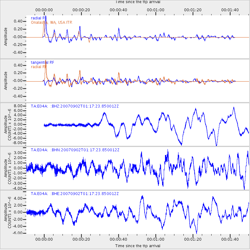
Signal To Noise
| Channel | StoN | STA | LTA |
| TA:E04A: :BHN:20070902T01:17:23.850012Z | 1.3937806 | 7.16707E-7 | 5.1421796E-7 |
| TA:E04A: :BHE:20070902T01:17:23.850012Z | 2.595907 | 1.2014509E-6 | 4.628251E-7 |
| TA:E04A: :BHZ:20070902T01:17:23.850012Z | 9.778131 | 3.0370954E-6 | 3.1060083E-7 |
| Arrivals |
| Ps | 1.4 SECOND |
| PpPs | 5.6 SECOND |
| PsPs/PpSs | 6.9 SECOND |


