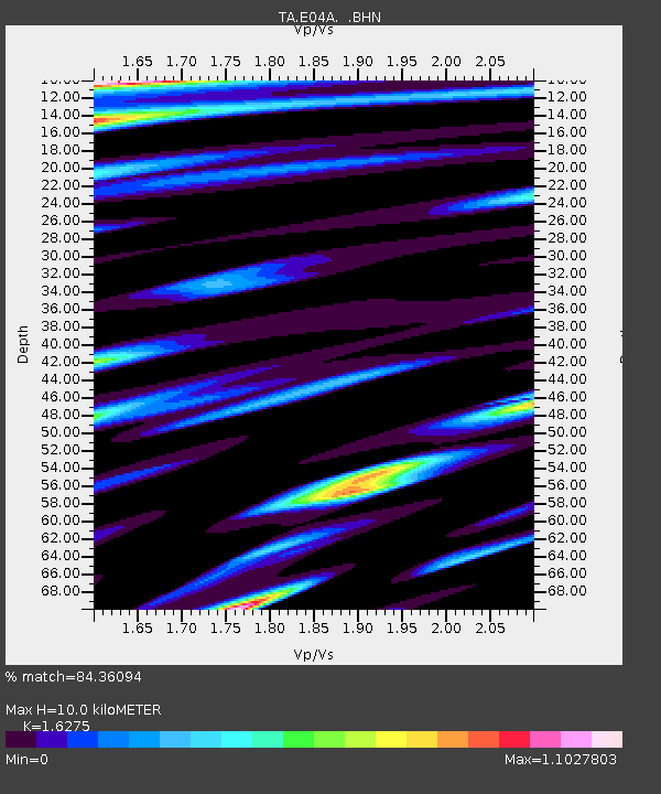
E04A Onalaska, WA, USA - Earthquake Result Viewer
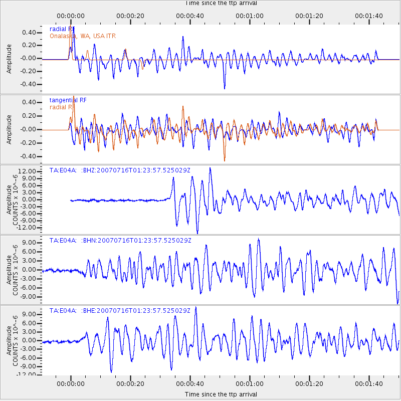
Earthquake location: Near West Coast Of Honshu, Japan
Earthquake latitude/longitude: 37.5/138.4
Earthquake time(UTC): 2007/07/16 (197) 01:13:22 GMT
Earthquake Depth: 12 km
Earthquake Magnitude: 6.5 MB, 6.4 MS, 6.6 MW, 6.5 MW
Earthquake Catalog/Contributor: WHDF/NEIC
Network: TA USArray Transportable Network (new EarthScope stations)
Station: E04A Onalaska, WA, USA
Lat/Lon: 46.59 N/122.72 W
Elevation: 215 m
Distance: 69.2 deg
Az: 46.798 deg
Baz: 302.828 deg
Ray Param: 0.055803303
Estimated Moho Depth: 10.0 km
Estimated Crust Vp/Vs: 1.63
Assumed Crust Vp: 6.566 km/s
Estimated Crust Vs: 4.035 km/s
Estimated Crust Poisson's Ratio: 0.20
Radial Match: 84.36094 %
Radial Bump: 400
Transverse Match: 76.61577 %
Transverse Bump: 400
SOD ConfigId: 2564
Insert Time: 2010-03-07 04:40:13.154 +0000
GWidth: 2.5
Max Bumps: 400
Tol: 0.001

Signal To Noise

ChannelStoNSTALTA
TA:E04A: :BHN:20070716T01:23:57.525029Z2.50013387.2334683E-72.8932325E-7
TA:E04A: :BHE:20070716T01:23:57.525029Z2.28913145.7641364E-72.5180452E-7
TA:E04A: :BHZ:20070716T01:23:57.525029Z16.5532513.1345878E-61.8936387E-7
Arrivals
Ps1.0 SECOND
PpPs3.8 SECOND
PsPs/PpSs4.8 SECOND