You are here: Home > Network List > TA - USArray Transportable Network (new EarthScope stations) Stations List
> Station E04A Onalaska, WA, USA > Earthquake Result Viewer
E04A Onalaska, WA, USA - Earthquake Result Viewer
| Earthquake location: |
Kuril Islands |
| Earthquake latitude/longitude: |
46.6/153.3 |
| Earthquake time(UTC): |
2006/11/15 (319) 11:14:13 GMT |
| Earthquake Depth: |
10 km |
| Earthquake Magnitude: |
6.5 MB, 7.8 MS, 8.3 MW, 7.9 MW |
| Earthquake Catalog/Contributor: |
WHDF/NEIC |
|
| Network: |
TA USArray Transportable Network (new EarthScope stations) |
| Station: |
E04A Onalaska, WA, USA |
| Lat/Lon: |
46.59 N/122.72 W |
| Elevation: |
215 m |
|
| Distance: |
55.0 deg |
| Az: |
56.886 deg |
| Baz: |
303.112 deg |
| Ray Param: |
0.06510537 |
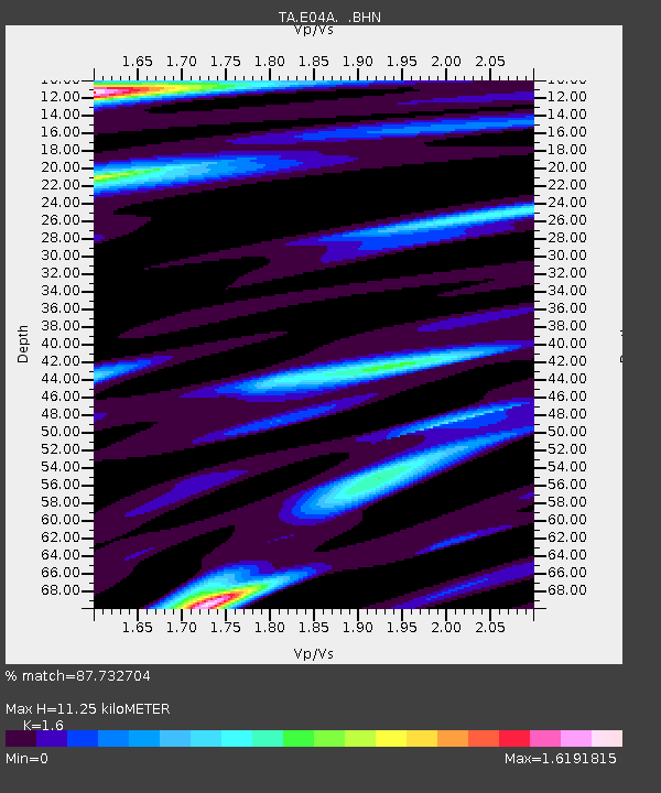
| Estimated Moho Depth: |
11.25 km |
| Estimated Crust Vp/Vs: |
1.60 |
| Assumed Crust Vp: |
6.566 km/s |
| Estimated Crust Vs: |
4.104 km/s |
| Estimated Crust Poisson's Ratio: |
0.18 |
|
| Radial Match: |
87.732704 % |
| Radial Bump: |
400 |
| Transverse Match: |
80.696396 % |
| Transverse Bump: |
400 |
| SOD ConfigId: |
2564 |
| Insert Time: |
2010-03-07 04:40:16.276 +0000 |
| GWidth: |
2.5 |
| Max Bumps: |
400 |
| Tol: |
0.001 |
|
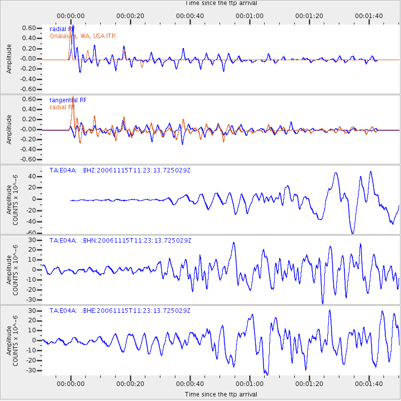
Signal To Noise
| Channel | StoN | STA | LTA |
| TA:E04A: :BHN:20061115T11:23:13.725029Z | 0.51389205 | 1.398731E-6 | 2.7218382E-6 |
| TA:E04A: :BHE:20061115T11:23:13.725029Z | 0.88863915 | 2.2369748E-6 | 2.517304E-6 |
| TA:E04A: :BHZ:20061115T11:23:13.725029Z | 4.3983693 | 3.2932674E-6 | 7.487473E-7 |
| Arrivals |
| Ps | 1.1 SECOND |
| PpPs | 4.2 SECOND |
| PsPs/PpSs | 5.3 SECOND |


