You are here: Home > Network List > TA - USArray Transportable Network (new EarthScope stations) Stations List
> Station E04A Onalaska, WA, USA > Earthquake Result Viewer
E04A Onalaska, WA, USA - Earthquake Result Viewer
| Earthquake location: |
Tonga Islands |
| Earthquake latitude/longitude: |
-15.2/-173.6 |
| Earthquake time(UTC): |
2006/07/07 (188) 07:26:12 GMT |
| Earthquake Depth: |
35 km |
| Earthquake Magnitude: |
5.7 MB, 5.9 MS, 6.0 MW, 6.0 MW |
| Earthquake Catalog/Contributor: |
WHDF/NEIC |
|
| Network: |
TA USArray Transportable Network (new EarthScope stations) |
| Station: |
E04A Onalaska, WA, USA |
| Lat/Lon: |
46.59 N/122.72 W |
| Elevation: |
215 m |
|
| Distance: |
76.7 deg |
| Az: |
33.361 deg |
| Baz: |
230.33 deg |
| Ray Param: |
0.050792404 |
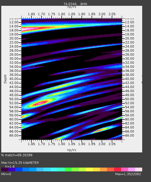
| Estimated Moho Depth: |
15.25 km |
| Estimated Crust Vp/Vs: |
1.60 |
| Assumed Crust Vp: |
6.566 km/s |
| Estimated Crust Vs: |
4.104 km/s |
| Estimated Crust Poisson's Ratio: |
0.18 |
|
| Radial Match: |
89.28299 % |
| Radial Bump: |
400 |
| Transverse Match: |
83.33662 % |
| Transverse Bump: |
400 |
| SOD ConfigId: |
2665 |
| Insert Time: |
2010-03-07 04:40:21.629 +0000 |
| GWidth: |
2.5 |
| Max Bumps: |
400 |
| Tol: |
0.001 |
|
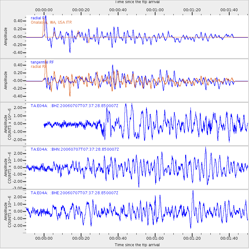
Signal To Noise
| Channel | StoN | STA | LTA |
| TA:E04A: :BHN:20060707T07:37:28.850007Z | 1.2027668 | 2.543335E-7 | 2.1145702E-7 |
| TA:E04A: :BHE:20060707T07:37:28.850007Z | 1.3773222 | 3.2153835E-7 | 2.334518E-7 |
| TA:E04A: :BHZ:20060707T07:37:28.850007Z | 4.9007816 | 8.7649653E-7 | 1.7884831E-7 |
| Arrivals |
| Ps | 1.4 SECOND |
| PpPs | 5.8 SECOND |
| PsPs/PpSs | 7.3 SECOND |


