You are here: Home > Network List > TA - USArray Transportable Network (new EarthScope stations) Stations List
> Station E04A Onalaska, WA, USA > Earthquake Result Viewer
E04A Onalaska, WA, USA - Earthquake Result Viewer
| Earthquake location: |
Solomon Islands |
| Earthquake latitude/longitude: |
-7.3/155.7 |
| Earthquake time(UTC): |
2007/04/01 (091) 21:11:33 GMT |
| Earthquake Depth: |
10 km |
| Earthquake Magnitude: |
6.3 MB |
| Earthquake Catalog/Contributor: |
WHDF/NEIC |
|
| Network: |
TA USArray Transportable Network (new EarthScope stations) |
| Station: |
E04A Onalaska, WA, USA |
| Lat/Lon: |
46.59 N/122.72 W |
| Elevation: |
215 m |
|
| Distance: |
89.5 deg |
| Az: |
43.01 deg |
| Baz: |
258.882 deg |
| Ray Param: |
0.041823417 |
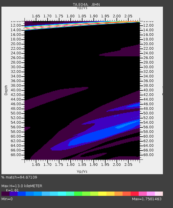
| Estimated Moho Depth: |
13.0 km |
| Estimated Crust Vp/Vs: |
1.61 |
| Assumed Crust Vp: |
6.566 km/s |
| Estimated Crust Vs: |
4.078 km/s |
| Estimated Crust Poisson's Ratio: |
0.19 |
|
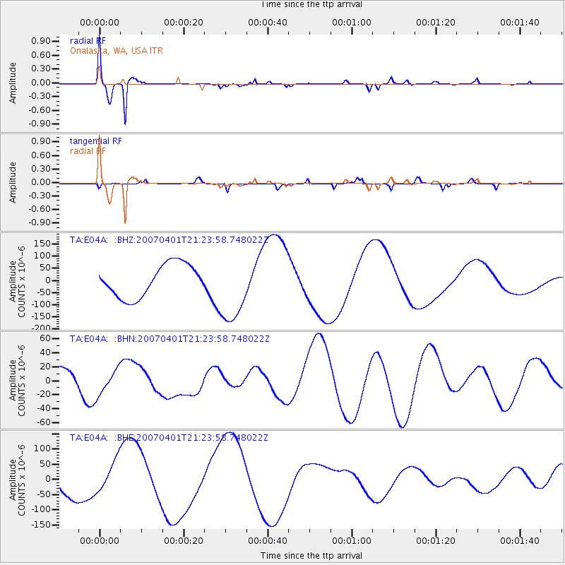
| Radial Match: |
94.67109 % |
| Radial Bump: |
400 |
| Transverse Match: |
54.850586 % |
| Transverse Bump: |
299 |
| SOD ConfigId: |
2564 |
| Insert Time: |
2010-03-07 04:40:32.552 +0000 |
| GWidth: |
2.5 |
| Max Bumps: |
400 |
| Tol: |
0.001 |
|
Signal To Noise
| Channel | StoN | STA | LTA |
| TA:E04A: :BHN:20070401T21:23:58.748022Z | 0.83080226 | 1.7134587E-5 | 2.0624146E-5 |
| TA:E04A: :BHE:20070401T21:23:58.748022Z | 1.1220978 | 5.9374433E-5 | 5.291378E-5 |
| TA:E04A: :BHZ:20070401T21:23:58.748022Z | 2.1465297 | 1.4257494E-4 | 6.642113E-5 |
| Arrivals |
| Ps | 1.2 SECOND |
| PpPs | 5.0 SECOND |
| PsPs/PpSs | 6.3 SECOND |


