You are here: Home > Network List > TA - USArray Transportable Network (new EarthScope stations) Stations List
> Station A10A Northport, WA, USA > Earthquake Result Viewer
A10A Northport, WA, USA - Earthquake Result Viewer
| Earthquake location: |
Kuril Islands |
| Earthquake latitude/longitude: |
46.3/153.3 |
| Earthquake time(UTC): |
2006/10/13 (286) 13:47:39 GMT |
| Earthquake Depth: |
8.0 km |
| Earthquake Magnitude: |
5.5 MB, 5.8 MS, 6.3 MW, 5.8 MW |
| Earthquake Catalog/Contributor: |
WHDF/NEIC |
|
| Network: |
TA USArray Transportable Network (new EarthScope stations) |
| Station: |
A10A Northport, WA, USA |
| Lat/Lon: |
48.98 N/117.56 W |
| Elevation: |
688 m |
|
| Distance: |
56.7 deg |
| Az: |
51.977 deg |
| Baz: |
303.929 deg |
| Ray Param: |
0.06394689 |
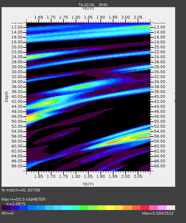
| Estimated Moho Depth: |
55.5 km |
| Estimated Crust Vp/Vs: |
2.10 |
| Assumed Crust Vp: |
6.571 km/s |
| Estimated Crust Vs: |
3.133 km/s |
| Estimated Crust Poisson's Ratio: |
0.35 |
|
| Radial Match: |
81.80786 % |
| Radial Bump: |
400 |
| Transverse Match: |
78.85232 % |
| Transverse Bump: |
400 |
| SOD ConfigId: |
2665 |
| Insert Time: |
2010-03-07 04:41:24.877 +0000 |
| GWidth: |
2.5 |
| Max Bumps: |
400 |
| Tol: |
0.001 |
|

Signal To Noise
| Channel | StoN | STA | LTA |
| TA:A10A: :BHN:20061013T13:56:53.04802Z | 1.6054059 | 1.9972188E-7 | 1.2440584E-7 |
| TA:A10A: :BHE:20061013T13:56:53.04802Z | 1.6757421 | 1.8510333E-7 | 1.1046051E-7 |
| TA:A10A: :BHZ:20061013T13:56:53.04802Z | 2.2120743 | 3.5291768E-7 | 1.5954151E-7 |
| Arrivals |
| Ps | 9.7 SECOND |
| PpPs | 25 SECOND |
| PsPs/PpSs | 35 SECOND |


