
Station TA A10A - Northport, WA, USA
Network: TA - USArray Transportable Network (new EarthScope stations)
Nearby stations (2 deg radius)
| Station | Name | (Lat, Lon) | Start / End | Elevation |
| A10A | Northport, WA, USA | (48.98, -117.56) | 2006-08-30 / 2499-01-01 | 0.7 km |
| Crust2 Type: | Q9,orogen/41km no ice, cordilleras, 0.25 km seds. |
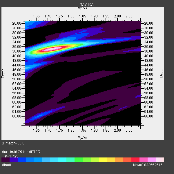
| Thickness Estimate: | 37 km |
| Thickness StdDev: | 0.3 km |
| Vp/Vs Estimate: | 1.73 |
| Vp/Vs StdDev: | 0.01 |
| Vs Estimate: | 3.809 km/s |
| Poisson's Ratio: | 0.25 |
| Peak Value: | 0.03 |
| Assumed Vp: | 6.571 km/s |
| Ps Weight: | 0.33333334 |
| PpPs Weight: | 0.33333334 |
| PsPs Weight: | 0.33333328 |
| Residual Complexity: | 0.319 |
| Nearby stations H: | +- |
| (2.0 deg) Vp/Vs: | +- |
12 with match > 90% ( 41.37931 %) and 29 with match > 80% ( 100.0 %) out of 29.
Download stack as xyz text file.
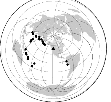
Azimuth Distribution of Events:
Prior Results for this Station
| Study | Thickness | Vp/Vs | Vp | Vs | Poissons Ratio | Extra |
| EARS | 37 km | 1.73 | 6.571 km/s | 3.809 km/s | 0.25 | |
| Crust2.0 | 41 km | 1.76 | 6.571 km/s | 3.735 km/s | 0.26 | Q9,orogen/41km no ice, cordilleras, 0.25 km seds. |
| Global Maxima | 37 km | 1.73 | 6.571 km/s | 3.809 km/s | 0.25 | amp=0.033552516 |
| Local Maxima 1 | 25 km | 1.60 | 6.571 km/s | 4.107 km/s | 0.18 | amp=0.012094976 |
| Local Maxima 2 | 36 km | 1.70 | 6.571 km/s | 3.877 km/s | 0.23 | amp=0.010068753 |
| Local Maxima 3 | 46 km | 1.60 | 6.571 km/s | 4.107 km/s | 0.18 | amp=0.007986119 |
| Local Maxima 4 | 38 km | 1.73 | 6.571 km/s | 3.809 km/s | 0.25 | amp=0.0065766852 |
| Predicted Arrivals for vertical incidence (zero ray parameter) | |
| Ps | 4.05 SECOND |
| PpPs | 15.24 SECOND |
| PsPs/PpSs | 19.30 SECOND |
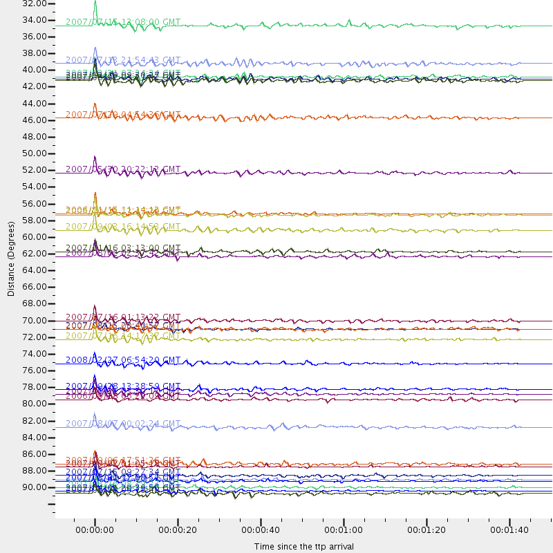
Events Processed for this Station
Download zip of receiver functions as SAC
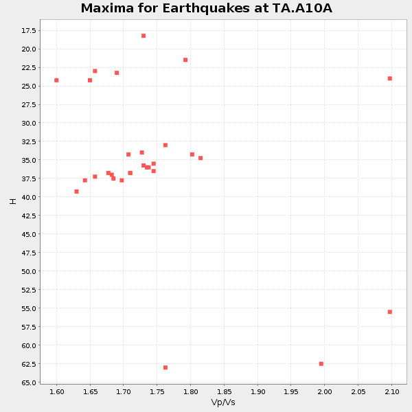
Plot maxima for each earthquake.
Events Used in the Stack
(29 events)| Radial Match | Distance | Baz | FERegion | Time | Lat/Lon | Depth | Magnitude |
| 98.23339 | 90.1 deg | 252.448 deg | Santa Cruz Islands | 2007/09/02 01:05:18 GMT | (-11.6, 165.8) | 35 km | 5.9 MB, 7.3 MS, 7.2 MW, 6.9 ME |
| 97.911804 | 56.5 deg | 304.257 deg | Kuril Islands | 2006/11/15 11:14:13 GMT | (46.6, 153.3) | 10 km | 6.5 MB, 7.8 MS, 8.3 MW, 7.9 MW |
| 97.292786 | 93.3 deg | 261.01 deg | Solomon Islands | 2007/04/01 20:39:56 GMT | (-8.5, 157.0) | 10 km | 6.8 MB, 7.9 MS, 8.1 MW, 7.7 ME |
| 97.036064 | 92.0 deg | 248.483 deg | Vanuatu Islands | 2007/08/01 17:08:51 GMT | (-15.6, 167.7) | 120 km | 6.2 MB, 7.2 MW, 7.2 MW |
| 96.56512 | 71.9 deg | 137.839 deg | Near Coast Of Peru | 2007/08/15 23:40:57 GMT | (-13.4, -76.6) | 39 km | 6.7 MB, 7.9 MS, 8.0 MW, 7.5 ME |
| 95.477646 | 79.8 deg | 291.711 deg | Volcano Islands, Japan Region | 2007/09/28 13:38:59 GMT | (22.0, 142.7) | 276 km | 6.7 MB, 7.4 MW, 7.4 MW |
| 94.900345 | 91.8 deg | 231.209 deg | South Of Fiji Islands | 2007/12/09 07:28:20 GMT | (-26.0, -177.5) | 152 km | 7.0 MB, 7.8 MW, 7.7 MW |
| 94.181366 | 80.5 deg | 287.7 deg | Mariana Islands | 2007/10/31 03:30:17 GMT | (18.9, 145.4) | 223 km | 6.2 MB, 7.2 MW, 7.2 MW |
| 91.901665 | 38.7 deg | 297.784 deg | Andreanof Islands, Aleutian Is. | 2007/12/19 09:30:27 GMT | (51.4, -179.5) | 29 km | 6.4 MB, 7.1 MS, 7.1 MW, 7.0 MW |
| 91.53794 | 71.9 deg | 306.225 deg | Near West Coast Of Honshu, Japan | 2007/03/25 00:41:57 GMT | (37.3, 136.6) | 8.0 km | 6.1 MB, 6.8 MS, 6.7 MW, 6.6 MW |
| 91.00451 | 62.2 deg | 310.64 deg | Sakhalin, Russia | 2007/08/02 02:37:42 GMT | (47.1, 141.8) | 5.0 km | 6.2 MS, 5.3 MB, 6.2 MW, 6.2 MW |
| 90.543335 | 91.2 deg | 247.933 deg | Vanuatu Islands | 2007/07/15 09:27:34 GMT | (-15.4, 168.6) | 8.0 km | 6.0 MB, 5.8 MS, 6.1 MW, 6.0 MW |
| 89.92012 | 73.2 deg | 306.952 deg | Sea Of Japan | 2007/07/16 14:17:37 GMT | (36.8, 134.9) | 350 km | 6.2 MB, 6.8 MW, 6.8 MW |
| 89.65584 | 58.8 deg | 305.209 deg | Kuril Islands | 2007/09/03 16:14:53 GMT | (45.8, 150.1) | 94 km | 6.3 MB, 6.2 MW, 6.2 ME |
| 89.36287 | 70.7 deg | 305.209 deg | Near West Coast Of Honshu, Japan | 2007/07/16 01:13:22 GMT | (37.5, 138.4) | 12 km | 6.5 MB, 6.4 MS, 6.6 MW, 6.5 MW |
| 89.078255 | 92.8 deg | 258.307 deg | Solomon Islands | 2007/08/16 08:39:27 GMT | (-9.8, 159.5) | 10 km | 6.1 MB, 6.7 MS, 6.4 MW |
| 88.4117 | 81.2 deg | 232.163 deg | Samoa Islands Region | 2006/09/28 06:22:09 GMT | (-16.6, -172.0) | 28 km | 6.5 MB, 6.6 MS, 6.9 MW, 6.7 MW |
| 88.22978 | 89.7 deg | 307.984 deg | Taiwan Region | 2007/09/06 17:51:26 GMT | (24.3, 122.2) | 53 km | 6.1 MB, 6.2 MW, 6.1 ME |
| 88.02454 | 61.6 deg | 133.436 deg | Peru-Ecuador Border Region | 2007/11/16 03:13:00 GMT | (-2.3, -77.8) | 123 km | 6.3 MB, 6.8 MW, 6.7 MW |
| 85.49684 | 31.6 deg | 295.835 deg | Fox Islands, Aleutian Islands | 2007/07/15 13:08:00 GMT | (52.5, -168.0) | 10 km | 5.8 MB, 5.9 MS, 6.1 MW, 6.0 MW |
| 84.13317 | 51.2 deg | 307.987 deg | Kamchatka Peninsula, Russia | 2007/05/30 20:22:12 GMT | (52.1, 157.3) | 116 km | 6.4 MB, 6.4 MW, 6.4 MW |
| 83.774864 | 38.4 deg | 297.577 deg | Andreanof Islands, Aleutian Is. | 2007/12/21 07:24:34 GMT | (51.4, -179.0) | 30 km | 6.1 MB, 6.2 MW, 6.3 ML |
| 82.82516 | 93.6 deg | 268.783 deg | New Ireland Region, P.N.G. | 2007/06/18 06:18:48 GMT | (-3.6, 151.0) | 26 km | 5.7 MB, 6.2 MS, 6.3 MW, 6.1 MW |
| 81.80786 | 56.7 deg | 303.929 deg | Kuril Islands | 2006/10/13 13:47:39 GMT | (46.3, 153.3) | 8.0 km | 5.5 MB, 5.8 MS, 6.3 MW, 5.8 MW |
| 81.41533 | 39.0 deg | 297.868 deg | Andreanof Islands, Aleutian Is. | 2007/08/02 03:21:42 GMT | (51.3, -180.0) | 21 km | 6.3 MB, 6.6 MS, 6.7 MW, 6.6 MW |
| 81.121315 | 76.4 deg | 295.108 deg | Bonin Islands, Japan Region | 2008/02/27 06:54:20 GMT | (26.8, 142.4) | 15 km | 5.8 MB, 6.1 MS, 6.2 MW, 6.2 MW |
| 81.000244 | 36.7 deg | 297.354 deg | Andreanof Islands, Aleutian Is. | 2007/07/13 21:54:43 GMT | (51.8, -176.3) | 35 km | 5.7 MB, 5.6 MS, 6.0 MW, 5.9 MW |
| 80.57424 | 43.9 deg | 304.881 deg | Komandorskiye Ostrova Region | 2007/07/29 04:54:36 GMT | (53.6, 169.7) | 26 km | 6.0 MB, 5.5 MS, 5.9 MW, 5.8 MW |
| 80.42678 | 84.9 deg | 306.314 deg | Northwest Of Ryukyu Islands | 2007/08/07 00:02:24 GMT | (27.3, 126.8) | 18 km | 5.5 MB, 5.8 MS, 5.9 MW, 5.9 MW |
Losers
(0 events)| Radial Match | Distance | Baz | FERegion | Time | Lat/Lon | Depth | Magnitude | Reason |
