You are here: Home > Network List > TA - USArray Transportable Network (new EarthScope stations) Stations List
> Station A10A Northport, WA, USA > Earthquake Result Viewer
A10A Northport, WA, USA - Earthquake Result Viewer
| Earthquake location: |
Kuril Islands |
| Earthquake latitude/longitude: |
45.8/150.1 |
| Earthquake time(UTC): |
2007/09/03 (246) 16:14:53 GMT |
| Earthquake Depth: |
94 km |
| Earthquake Magnitude: |
6.3 MB, 6.2 MW, 6.2 ME |
| Earthquake Catalog/Contributor: |
WHDF/NEIC |
|
| Network: |
TA USArray Transportable Network (new EarthScope stations) |
| Station: |
A10A Northport, WA, USA |
| Lat/Lon: |
48.98 N/117.56 W |
| Elevation: |
688 m |
|
| Distance: |
58.8 deg |
| Az: |
50.349 deg |
| Baz: |
305.209 deg |
| Ray Param: |
0.06237165 |
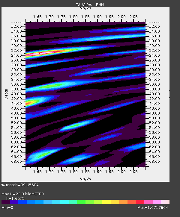
| Estimated Moho Depth: |
23.0 km |
| Estimated Crust Vp/Vs: |
1.66 |
| Assumed Crust Vp: |
6.571 km/s |
| Estimated Crust Vs: |
3.964 km/s |
| Estimated Crust Poisson's Ratio: |
0.21 |
|
| Radial Match: |
89.65584 % |
| Radial Bump: |
400 |
| Transverse Match: |
83.02636 % |
| Transverse Bump: |
400 |
| SOD ConfigId: |
2564 |
| Insert Time: |
2010-03-07 04:41:40.463 +0000 |
| GWidth: |
2.5 |
| Max Bumps: |
400 |
| Tol: |
0.001 |
|
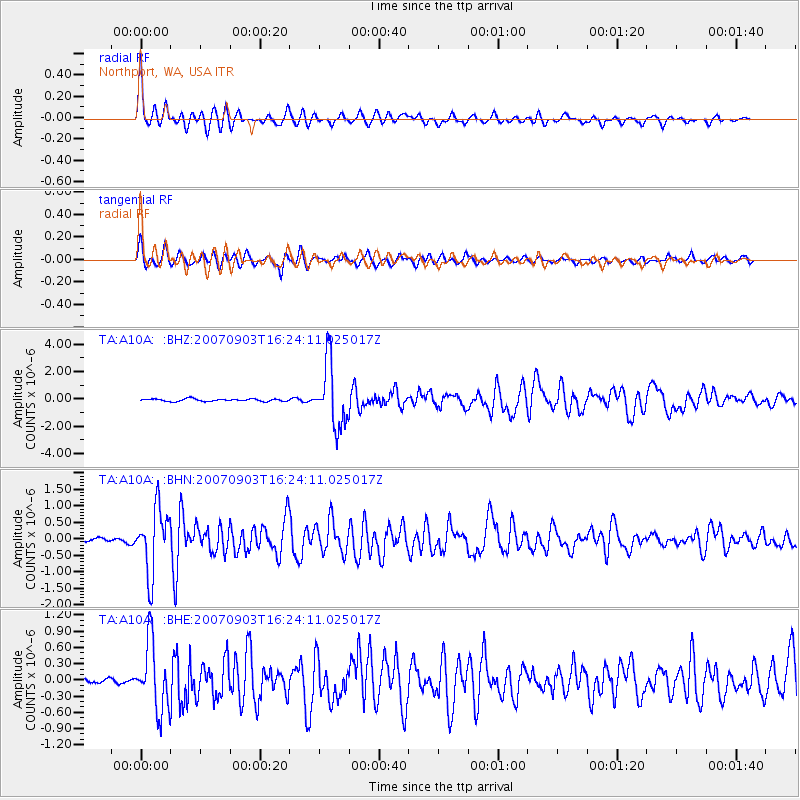
Signal To Noise
| Channel | StoN | STA | LTA |
| TA:A10A: :BHN:20070903T16:24:11.025017Z | 16.160482 | 9.738692E-7 | 6.026239E-8 |
| TA:A10A: :BHE:20070903T16:24:11.025017Z | 5.620233 | 6.1928154E-7 | 1.1018787E-7 |
| TA:A10A: :BHZ:20070903T16:24:11.025017Z | 25.329405 | 2.3241328E-6 | 9.175631E-8 |
| Arrivals |
| Ps | 2.4 SECOND |
| PpPs | 8.8 SECOND |
| PsPs/PpSs | 11 SECOND |


