You are here: Home > Network List > TA - USArray Transportable Network (new EarthScope stations) Stations List
> Station A10A Northport, WA, USA > Earthquake Result Viewer
A10A Northport, WA, USA - Earthquake Result Viewer

| Earthquake location: |
Near Coast Of Peru |
| Earthquake latitude/longitude: |
-13.4/-76.6 |
| Earthquake time(UTC): |
2007/08/15 (227) 23:40:57 GMT |
| Earthquake Depth: |
39 km |
| Earthquake Magnitude: |
6.7 MB, 7.9 MS, 8.0 MW, 7.5 ME |
| Earthquake Catalog/Contributor: |
WHDF/NEIC |
|
| Network: |
TA USArray Transportable Network (new EarthScope stations) |
| Station: |
A10A Northport, WA, USA |
| Lat/Lon: |
48.98 N/117.56 W |
| Elevation: |
688 m |
|
| Distance: |
71.9 deg |
| Az: |
332.974 deg |
| Baz: |
137.839 deg |
| Ray Param: |
0.053972423 |
| Estimated Moho Depth: |
24.25 km |
| Estimated Crust Vp/Vs: |
1.65 |
| Assumed Crust Vp: |
6.571 km/s |
| Estimated Crust Vs: |
3.982 km/s |
| Estimated Crust Poisson's Ratio: |
0.21 |
|
| Radial Match: |
96.56512 % |
| Radial Bump: |
293 |
| Transverse Match: |
92.2238 % |
| Transverse Bump: |
400 |
| SOD ConfigId: |
2564 |
| Insert Time: |
2010-03-07 04:41:46.020 +0000 |
| GWidth: |
2.5 |
| Max Bumps: |
400 |
| Tol: |
0.001 |
|
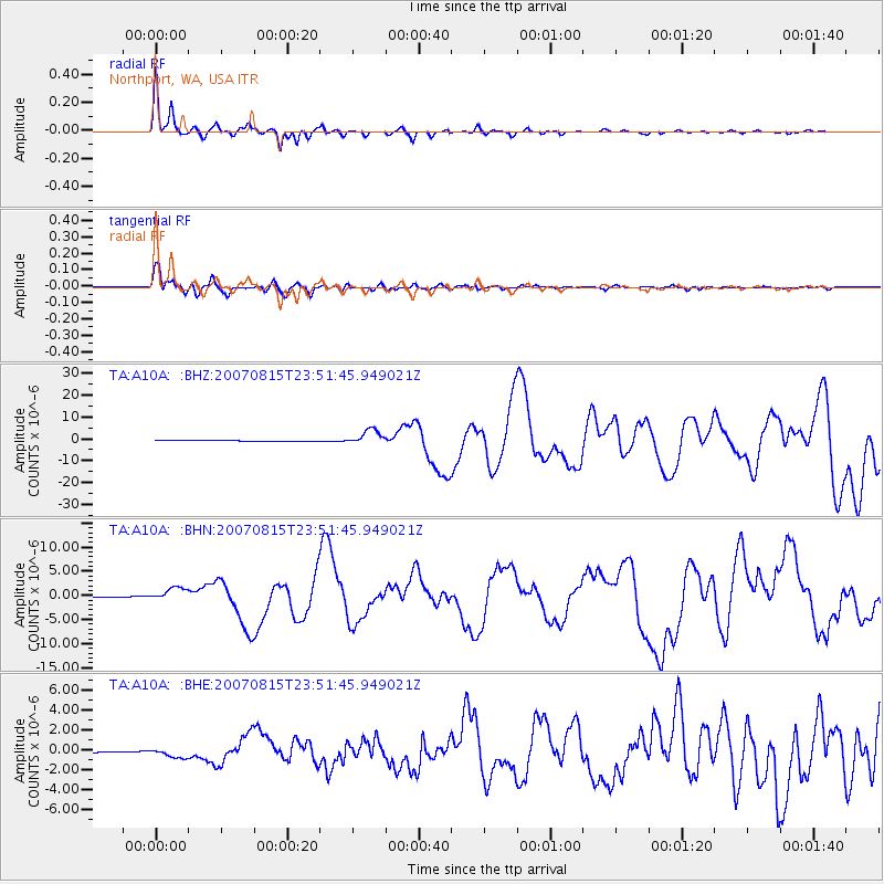
Signal To Noise
| Channel | StoN | STA | LTA |
| TA:A10A: :BHN:20070815T23:51:45.949021Z | 27.851202 | 1.3835981E-6 | 4.967822E-8 |
| TA:A10A: :BHE:20070815T23:51:45.949021Z | 10.108335 | 4.5676444E-7 | 4.5186916E-8 |
| TA:A10A: :BHZ:20070815T23:51:45.949021Z | 35.44134 | 3.5248315E-6 | 9.945536E-8 |
| Arrivals |
| Ps | 2.5 SECOND |
| PpPs | 9.4 SECOND |
| PsPs/PpSs | 12 SECOND |


