You are here: Home > Network List > TA - USArray Transportable Network (new EarthScope stations) Stations List
> Station A10A Northport, WA, USA > Earthquake Result Viewer
A10A Northport, WA, USA - Earthquake Result Viewer
| Earthquake location: |
Northwest Of Ryukyu Islands |
| Earthquake latitude/longitude: |
27.3/126.8 |
| Earthquake time(UTC): |
2007/08/07 (219) 00:02:24 GMT |
| Earthquake Depth: |
18 km |
| Earthquake Magnitude: |
5.5 MB, 5.8 MS, 5.9 MW, 5.9 MW |
| Earthquake Catalog/Contributor: |
WHDF/NEIC |
|
| Network: |
TA USArray Transportable Network (new EarthScope stations) |
| Station: |
A10A Northport, WA, USA |
| Lat/Lon: |
48.98 N/117.56 W |
| Elevation: |
688 m |
|
| Distance: |
84.9 deg |
| Az: |
36.621 deg |
| Baz: |
306.314 deg |
| Ray Param: |
0.045171876 |
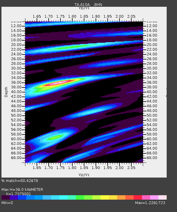
| Estimated Moho Depth: |
36.0 km |
| Estimated Crust Vp/Vs: |
1.74 |
| Assumed Crust Vp: |
6.571 km/s |
| Estimated Crust Vs: |
3.782 km/s |
| Estimated Crust Poisson's Ratio: |
0.25 |
|
| Radial Match: |
80.42678 % |
| Radial Bump: |
400 |
| Transverse Match: |
72.27459 % |
| Transverse Bump: |
400 |
| SOD ConfigId: |
2564 |
| Insert Time: |
2010-03-07 04:41:47.999 +0000 |
| GWidth: |
2.5 |
| Max Bumps: |
400 |
| Tol: |
0.001 |
|

Signal To Noise
| Channel | StoN | STA | LTA |
| TA:A10A: :BHN:20070807T00:14:26.173022Z | 0.9863587 | 3.297371E-8 | 3.3429732E-8 |
| TA:A10A: :BHE:20070807T00:14:26.173022Z | 0.7074445 | 2.9770485E-8 | 4.2081727E-8 |
| TA:A10A: :BHZ:20070807T00:14:26.173022Z | 2.2637048 | 1.15866115E-7 | 5.1184287E-8 |
| Arrivals |
| Ps | 4.1 SECOND |
| PpPs | 15 SECOND |
| PsPs/PpSs | 19 SECOND |


