You are here: Home > Network List > TA - USArray Transportable Network (new EarthScope stations) Stations List
> Station A10A Northport, WA, USA > Earthquake Result Viewer
A10A Northport, WA, USA - Earthquake Result Viewer
| Earthquake location: |
Sea Of Japan |
| Earthquake latitude/longitude: |
36.8/134.9 |
| Earthquake time(UTC): |
2007/07/16 (197) 14:17:37 GMT |
| Earthquake Depth: |
350 km |
| Earthquake Magnitude: |
6.2 MB, 6.8 MW, 6.8 MW |
| Earthquake Catalog/Contributor: |
WHDF/NEIC |
|
| Network: |
TA USArray Transportable Network (new EarthScope stations) |
| Station: |
A10A Northport, WA, USA |
| Lat/Lon: |
48.98 N/117.56 W |
| Elevation: |
688 m |
|
| Distance: |
73.2 deg |
| Az: |
40.995 deg |
| Baz: |
306.952 deg |
| Ray Param: |
0.05212748 |
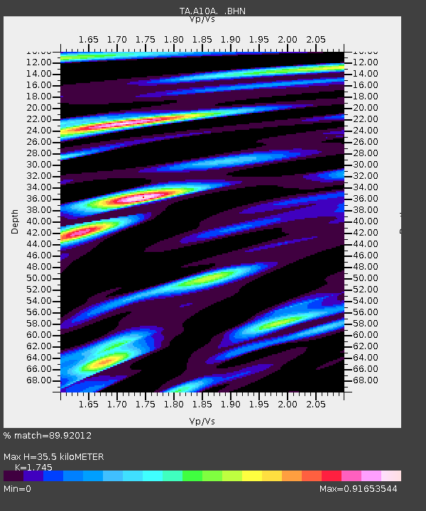
| Estimated Moho Depth: |
35.5 km |
| Estimated Crust Vp/Vs: |
1.75 |
| Assumed Crust Vp: |
6.571 km/s |
| Estimated Crust Vs: |
3.765 km/s |
| Estimated Crust Poisson's Ratio: |
0.26 |
|
| Radial Match: |
89.92012 % |
| Radial Bump: |
400 |
| Transverse Match: |
75.232124 % |
| Transverse Bump: |
400 |
| SOD ConfigId: |
2564 |
| Insert Time: |
2010-03-07 04:41:57.470 +0000 |
| GWidth: |
2.5 |
| Max Bumps: |
400 |
| Tol: |
0.001 |
|
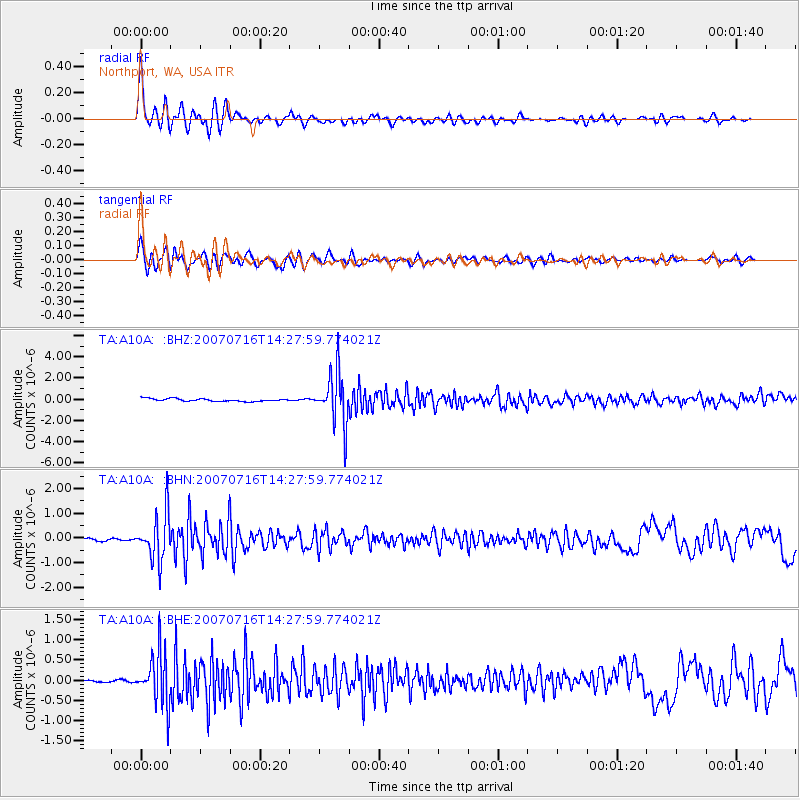
Signal To Noise
| Channel | StoN | STA | LTA |
| TA:A10A: :BHN:20070716T14:27:59.774021Z | 20.056984 | 9.380887E-7 | 4.6771177E-8 |
| TA:A10A: :BHE:20070716T14:27:59.774021Z | 35.382042 | 6.4057673E-7 | 1.8104572E-8 |
| TA:A10A: :BHZ:20070716T14:27:59.774021Z | 19.169403 | 2.4118963E-6 | 1.2582011E-7 |
| Arrivals |
| Ps | 4.2 SECOND |
| PpPs | 14 SECOND |
| PsPs/PpSs | 18 SECOND |


