You are here: Home > Network List > TA - USArray Transportable Network (new EarthScope stations) Stations List
> Station F26A Lodgepole, SD, USA > Earthquake Result Viewer
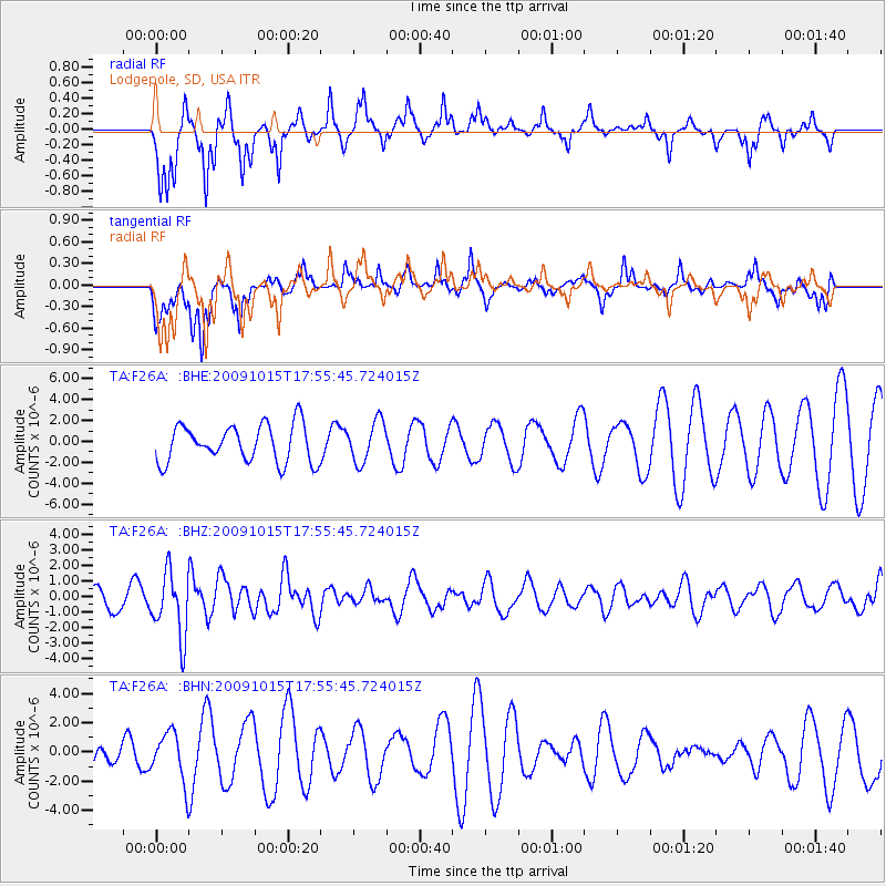
F26A Lodgepole, SD, USA - Earthquake Result Viewer
*The percent match for this event was below the threshold and hence no stack was calculated.
| Earthquake location: |
Galapagos Triple Junction Region |
| Earthquake latitude/longitude: |
3.3/-103.8 |
| Earthquake time(UTC): |
2009/10/15 (288) 17:48:21 GMT |
| Earthquake Depth: |
10 km |
| Earthquake Magnitude: |
5.9 MB, 5.7 MS, 6.0 MW, 6.0 MW |
| Earthquake Catalog/Contributor: |
WHDF/NEIC |
|
| Network: |
TA USArray Transportable Network (new EarthScope stations) |
| Station: |
F26A Lodgepole, SD, USA |
| Lat/Lon: |
45.85 N/102.67 W |
| Elevation: |
852 m |
|
| Distance: |
42.4 deg |
| Az: |
1.195 deg |
| Baz: |
181.707 deg |
| Ray Param: |
$rayparam |
*The percent match for this event was below the threshold and hence was not used in the summary stack. |
|
| Radial Match: |
79.680435 % |
| Radial Bump: |
339 |
| Transverse Match: |
57.33737 % |
| Transverse Bump: |
361 |
| SOD ConfigId: |
2622 |
| Insert Time: |
2010-03-07 06:09:50.690 +0000 |
| GWidth: |
2.5 |
| Max Bumps: |
400 |
| Tol: |
0.001 |
|
Signal To Noise
| Channel | StoN | STA | LTA |
| TA:F26A: :BHZ:20091015T17:55:45.724015Z | 3.238172 | 2.0509824E-6 | 6.333766E-7 |
| TA:F26A: :BHN:20091015T17:55:45.724015Z | 1.2328956 | 1.6502729E-6 | 1.3385343E-6 |
| TA:F26A: :BHE:20091015T17:55:45.724015Z | 1.1087052 | 1.9683691E-6 | 1.7753766E-6 |
| Arrivals |
| Ps | |
| PpPs | |
| PsPs/PpSs | |


