
Station TA F26A - Lodgepole, SD, USA
Network: TA - USArray Transportable Network (new EarthScope stations)
Nearby stations (2 deg radius)
| Station | Name | (Lat, Lon) | Start / End | Elevation |
| F26A | Lodgepole, SD, USA | (45.85, -102.67) | 2009-07-12 / 2599-12-31 | 852 m |
| Crust2 Type: | PD,orogen/50km, Tibet, 2 km seds. |
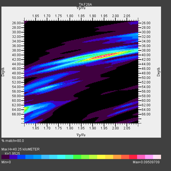
| Thickness Estimate: | 40 km |
| Thickness StdDev: | 6.5 km |
| Vp/Vs Estimate: | 1.95 |
| Vp/Vs StdDev: | 0.11 |
| Vs Estimate: | 3.197 km/s |
| Poisson's Ratio: | 0.32 |
| Peak Value: | 0.10 |
| Assumed Vp: | 6.242 km/s |
| Ps Weight: | 0.33333334 |
| PpPs Weight: | 0.33333334 |
| PsPs Weight: | 0.33333328 |
| Residual Complexity: | 0.521 |
| Nearby stations H: | +- |
| (2.0 deg) Vp/Vs: | +- |
2 with match > 90% ( 9.090909 %) and 2 with match > 80% ( 9.090909 %) out of 22.
Download stack as xyz text file.
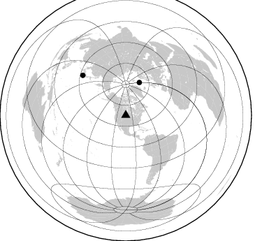
Azimuth Distribution of Events:
Prior Results for this Station
| Study | Thickness | Vp/Vs | Vp | Vs | Poissons Ratio | Extra |
| EARS | 40 km | 1.95 | 6.242 km/s | 3.197 km/s | 0.32 | |
| Crust2.0 | 50 km | 1.76 | 6.242 km/s | 3.546 km/s | 0.26 | PD,orogen/50km, Tibet, 2 km seds. |
| Global Maxima | 40 km | 1.95 | 6.242 km/s | 3.197 km/s | 0.32 | amp=0.09509709 |
| Local Maxima 1 | 64 km | 1.60 | 6.242 km/s | 3.901 km/s | 0.18 | amp=0.046003677 |
| Local Maxima 2 | 54 km | 1.70 | 6.242 km/s | 3.672 km/s | 0.24 | amp=0.038800545 |
| Local Maxima 3 | 40 km | 1.86 | 6.242 km/s | 3.365 km/s | 0.30 | amp=0.032951377 |
| Local Maxima 4 | 45 km | 1.75 | 6.242 km/s | 3.572 km/s | 0.26 | amp=0.025140222 |
| Predicted Arrivals for vertical incidence (zero ray parameter) | |
| Ps | 6.14 SECOND |
| PpPs | 19.04 SECOND |
| PsPs/PpSs | 25.18 SECOND |
Events Processed for this Station
Download zip of receiver functions as SAC
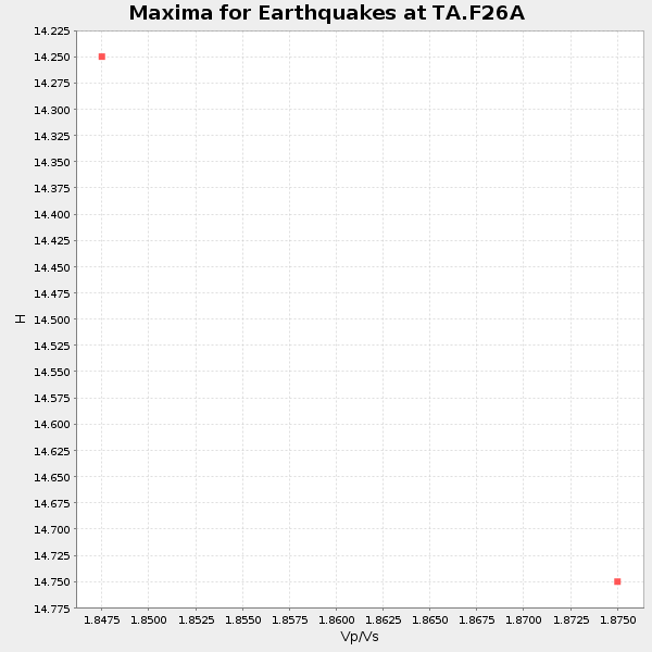
Plot maxima for each earthquake.
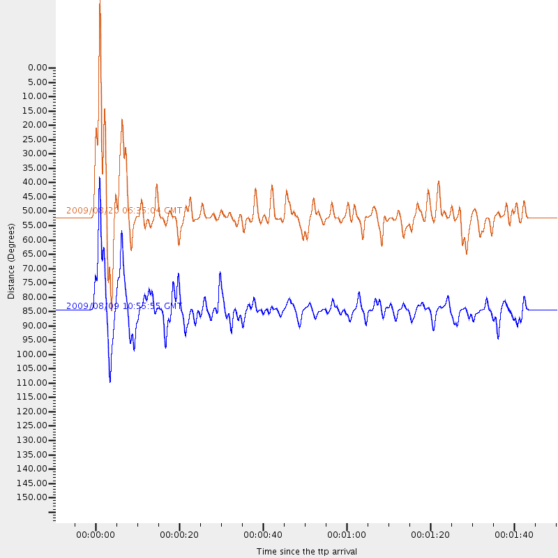
Events Used in the Stack
(2 events)| Radial Match | Distance | Baz | FERegion | Time | Lat/Lon | Depth | Magnitude |
| 94.82242 | 51.0 deg | 22.636 deg | Norwegian Sea | 2009/08/20 06:35:04 GMT | (72.2, 0.9) | 6.0 km | 5.9 MB, 5.7 MS, 6.0 MW, 6.0 MW |
| 92.49465 | 84.2 deg | 312.724 deg | Near S. Coast Of Honshu, Japan | 2009/08/09 10:55:55 GMT | (33.2, 137.9) | 297 km | 6.5 MB, 7.1 MW, 7.1 MW |
Losers
(20 events)| Radial Match | Distance | Baz | FERegion | Time | Lat/Lon | Depth | Magnitude | Reason |
| 92.977585 | 45.9 deg | 128.684 deg | Near Coast Of Venezuela | 2009/09/12 20:06:24 GMT | (10.7, -67.9) | 10 km | 6.3 MB, 6.4 MS, 6.3 MW, 6.3 MW | |
| 85.09381 | 40.5 deg | 153.47 deg | Off Coast Of Costa Rica | 2009/08/13 09:37:35 GMT | (7.9, -85.6) | 10 km | 5.8 MW, 5.3 MB | |
| 79.680435 | 42.4 deg | 181.707 deg | Galapagos Triple Junction Region | 2009/10/15 17:48:21 GMT | (3.3, -103.8) | 10 km | 5.9 MB, 5.7 MS, 6.0 MW, 6.0 MW | |
| 75.12558 | 88.6 deg | 247.0 deg | Samoa Islands Region | 2009/10/14 18:00:21 GMT | (-14.9, -174.8) | 10 km | 5.7 MB, 6.0 MS, 6.3 MW, 6.2 MW | |
| 70.42056 | 41.2 deg | 303.796 deg | Fox Islands, Aleutian Islands | 2009/10/13 05:37:23 GMT | (52.8, -167.0) | 24 km | 6.0 MB, 6.1 MS, 6.5 MW, 6.5 MW | |
| 66.207695 | 91.4 deg | 316.109 deg | Ryukyu Islands, Japan | 2009/10/30 07:03:39 GMT | (29.2, 129.8) | 34 km | 6.3 MB, 6.8 MS, 6.8 MW, 6.8 MW | |
| 65.464195 | 51.3 deg | 75.071 deg | Azores Islands Region | 2009/11/04 18:41:44 GMT | (36.2, -33.9) | 10 km | 5.7 MB, 5.6 MS, 5.9 MW, 5.8 MW | |
| 64.40316 | 67.4 deg | 145.881 deg | Southern Peru | 2009/09/05 03:58:39 GMT | (-15.1, -70.2) | 210 km | 5.8 MW, 5.2 MB, 5.8 MW | |
| 56.65139 | 89.7 deg | 316.999 deg | Kyushu, Japan | 2009/09/03 13:26:18 GMT | (31.1, 130.0) | 166 km | 5.9 MB, 6.2 MW, 6.2 MW | |
| 55.374992 | 89.5 deg | 302.436 deg | Volcano Islands, Japan Region | 2009/07/29 14:52:08 GMT | (22.6, 143.3) | 140 km | 5.5 MW, 5.2 MB, 5.4 MW | |
| 54.81505 | 88.2 deg | 245.492 deg | Tonga Islands | 2009/09/29 23:11:51 GMT | (-15.6, -173.4) | 10 km | 5.5 MB | |
| 54.496807 | 87.3 deg | 244.848 deg | Samoa Islands Region | 2009/10/19 22:49:38 GMT | (-15.4, -172.3) | 18 km | 6.2 MB, 5.7 MS, 6.0 MW, 5.9 MW | |
| 53.32638 | 80.3 deg | 148.15 deg | Catamarca Province, Argentina | 2009/08/12 18:00:52 GMT | (-27.9, -66.7) | 174 km | 5.5 MW, 5.3 MB, 5.5 MW | |
| 53.275417 | 68.2 deg | 145.162 deg | Peru-Bolivia Border Region | 2009/09/30 19:03:17 GMT | (-15.6, -69.3) | 255 km | 5.9 MB, 5.8 MW | |
| 53.044586 | 49.9 deg | 307.743 deg | Rat Islands, Aleutian Islands | 2009/10/07 05:38:37 GMT | (52.2, 178.1) | 138 km | 5.6 MB, 5.6 MW, 5.6 MW | |
| 52.674015 | 64.8 deg | 314.018 deg | Kuril Islands | 2009/09/11 08:49:11 GMT | (48.3, 154.2) | 35 km | 5.8 MB, 5.0 MS, 5.6 MW, 5.6 MW | |
| 50.262283 | 92.7 deg | 242.67 deg | Tonga Islands | 2009/07/30 20:05:34 GMT | (-20.8, -174.3) | 10 km | 5.9 MB, 5.7 MS, 5.8 MW, 5.7 MW | |
| 48.746895 | 97.9 deg | 316.973 deg | Southwestern Ryukyu Isl., Japan | 2009/08/05 00:17:58 GMT | (24.2, 125.1) | 25 km | 5.9 MB, 5.9 MS, 6.2 MW, 6.1 MW | |
| 48.42355 | 97.8 deg | 5.184 deg | Hindu Kush Region, Afghanistan | 2009/10/22 19:51:27 GMT | (36.5, 70.9) | 186 km | 6.1 MB, 6.2 MW, 6.1 MW | |
| 47.626503 | 93.5 deg | 242.349 deg | Tonga Islands | 2009/08/13 11:17:01 GMT | (-21.7, -174.6) | 10 km | 5.6 MW, 5.3 MB |
