You are here: Home > Network List > TA - USArray Transportable Network (new EarthScope stations) Stations List
> Station A25A Svangstu Ranch, Noonan, ND, USA > Earthquake Result Viewer
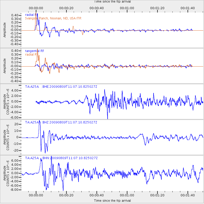
A25A Svangstu Ranch, Noonan, ND, USA - Earthquake Result Viewer
| Earthquake location: |
Near S. Coast Of Honshu, Japan |
| Earthquake latitude/longitude: |
33.2/137.9 |
| Earthquake time(UTC): |
2009/08/09 (221) 10:55:55 GMT |
| Earthquake Depth: |
297 km |
| Earthquake Magnitude: |
6.5 MB, 7.1 MW, 7.1 MW |
| Earthquake Catalog/Contributor: |
WHDF/NEIC |
|
| Network: |
TA USArray Transportable Network (new EarthScope stations) |
| Station: |
A25A Svangstu Ranch, Noonan, ND, USA |
| Lat/Lon: |
48.94 N/103.11 W |
| Elevation: |
584 m |
|
| Distance: |
81.9 deg |
| Az: |
35.653 deg |
| Baz: |
312.144 deg |
| Ray Param: |
0.04652607 |
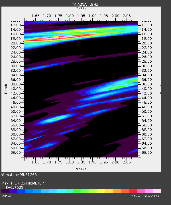
| Estimated Moho Depth: |
17.25 km |
| Estimated Crust Vp/Vs: |
1.75 |
| Assumed Crust Vp: |
6.438 km/s |
| Estimated Crust Vs: |
3.673 km/s |
| Estimated Crust Poisson's Ratio: |
0.26 |
|
| Radial Match: |
95.61268 % |
| Radial Bump: |
370 |
| Transverse Match: |
82.36318 % |
| Transverse Bump: |
400 |
| SOD ConfigId: |
2622 |
| Insert Time: |
2010-03-07 06:11:48.571 +0000 |
| GWidth: |
2.5 |
| Max Bumps: |
400 |
| Tol: |
0.001 |
|
Signal To Noise
| Channel | StoN | STA | LTA |
| TA:A25A: :BHZ:20090809T11:07:10.825027Z | 85.73973 | 1.1277015E-5 | 1.3152614E-7 |
| TA:A25A: :BHN:20090809T11:07:10.825027Z | 11.267294 | 3.1381144E-6 | 2.7851533E-7 |
| TA:A25A: :BHE:20090809T11:07:10.825027Z | 4.163709 | 1.0721336E-6 | 2.5749483E-7 |
| Arrivals |
| Ps | 2.1 SECOND |
| PpPs | 7.2 SECOND |
| PsPs/PpSs | 9.3 SECOND |


