
Station TA A25A - Svangstu Ranch, Noonan, ND, USA
Network: TA - USArray Transportable Network (new EarthScope stations)
Nearby stations (2 deg radius)
| Station | Name | (Lat, Lon) | Start / End | Elevation |
| A25A | Svangstu Ranch, Noonan, ND, USA | (48.94, -103.11) | 2009-07-24 / 2599-12-31 | 584 m |
| Crust2 Type: | H5,early/mid Proter. shield, Africa, 3 km seds. |
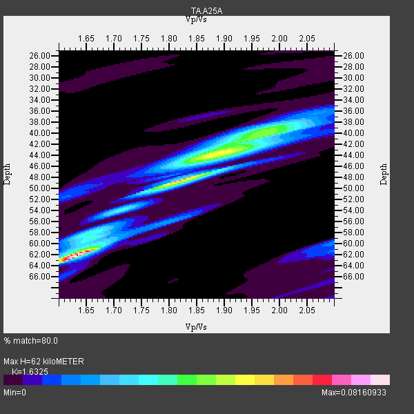
| Thickness Estimate: | 62 km |
| Thickness StdDev: | 11 km |
| Vp/Vs Estimate: | 1.63 |
| Vp/Vs StdDev: | 0.19 |
| Vs Estimate: | 3.943 km/s |
| Poisson's Ratio: | 0.20 |
| Peak Value: | 0.08 |
| Assumed Vp: | 6.438 km/s |
| Ps Weight: | 0.33333334 |
| PpPs Weight: | 0.33333334 |
| PsPs Weight: | 0.33333328 |
| Residual Complexity: | 0.808 |
| Nearby stations H: | +- |
| (2.0 deg) Vp/Vs: | +- |
1 with match > 90% ( 3.8461537 %) and 2 with match > 80% ( 7.6923075 %) out of 26.
Download stack as xyz text file.
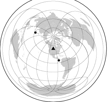
Azimuth Distribution of Events:
Prior Results for this Station
| Study | Thickness | Vp/Vs | Vp | Vs | Poissons Ratio | Extra |
| EARS | 62 km | 1.63 | 6.438 km/s | 3.943 km/s | 0.20 | |
| Crust2.0 | 48 km | 1.78 | 6.438 km/s | 3.613 km/s | 0.27 | H5,early/mid Proter. shield, Africa, 3 km seds. |
| Global Maxima | 62 km | 1.63 | 6.438 km/s | 3.943 km/s | 0.20 | amp=0.08160933 |
| Local Maxima 1 | 48 km | 1.82 | 6.438 km/s | 3.542 km/s | 0.28 | amp=0.056097373 |
| Local Maxima 2 | 44 km | 1.88 | 6.438 km/s | 3.424 km/s | 0.30 | amp=0.041172694 |
| Local Maxima 3 | 40 km | 1.98 | 6.438 km/s | 3.259 km/s | 0.33 | amp=0.028222403 |
| Local Maxima 4 | 58 km | 1.64 | 6.438 km/s | 3.925 km/s | 0.20 | amp=0.017588954 |
| Predicted Arrivals for vertical incidence (zero ray parameter) | |
| Ps | 6.09 SECOND |
| PpPs | 25.35 SECOND |
| PsPs/PpSs | 31.45 SECOND |
Events Processed for this Station
Download zip of receiver functions as SAC
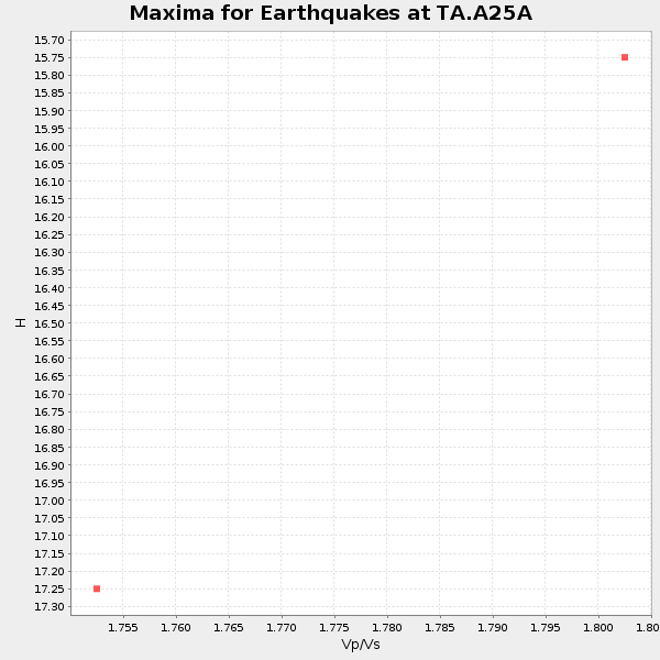
Plot maxima for each earthquake.
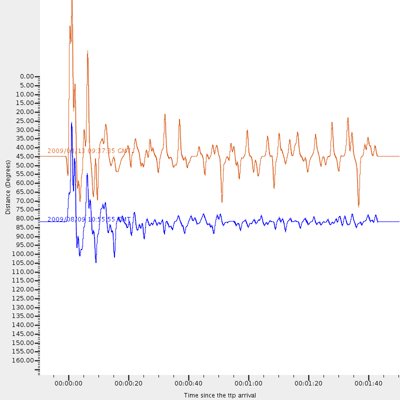
Events Used in the Stack
(2 events)| Radial Match | Distance | Baz | FERegion | Time | Lat/Lon | Depth | Magnitude |
| 95.61268 | 81.9 deg | 312.144 deg | Near S. Coast Of Honshu, Japan | 2009/08/09 10:55:55 GMT | (33.2, 137.9) | 297 km | 6.5 MB, 7.1 MW, 7.1 MW |
| 83.76643 | 43.4 deg | 154.355 deg | Off Coast Of Costa Rica | 2009/08/13 09:37:35 GMT | (7.9, -85.6) | 10 km | 5.8 MW, 5.3 MB |
Losers
(24 events)| Radial Match | Distance | Baz | FERegion | Time | Lat/Lon | Depth | Magnitude | Reason |
| 98.38245 | 88.4 deg | 244.206 deg | Samoa Islands Region | 2009/09/29 17:48:10 GMT | (-15.5, -172.1) | 18 km | 7.1 MB, 8.1 MS, 8.1 MW, 8.0 MW | |
| 97.08551 | 80.9 deg | 310.255 deg | Southeast Of Honshu, Japan | 2009/08/12 22:48:51 GMT | (32.8, 140.4) | 53 km | 6.2 MB, 6.6 MW, 6.6 MW | |
| 90.764465 | 48.1 deg | 130.405 deg | Near Coast Of Venezuela | 2009/09/12 20:06:24 GMT | (10.7, -67.9) | 10 km | 6.3 MB, 6.4 MS, 6.3 MW, 6.3 MW | |
| 83.00637 | 30.2 deg | 187.979 deg | Off Coast Of Jalisco, Mexico | 2009/09/24 07:16:19 GMT | (18.8, -107.3) | 10 km | 5.8 MB, 6.2 MS, 6.3 MW, 6.3 MW | |
| 81.48725 | 70.9 deg | 145.402 deg | Peru-Bolivia Border Region | 2009/09/30 19:03:17 GMT | (-15.6, -69.3) | 255 km | 5.9 MB, 5.8 MW | |
| 77.9886 | 89.0 deg | 315.791 deg | Ryukyu Islands, Japan | 2009/10/30 07:03:39 GMT | (29.2, 129.8) | 34 km | 6.3 MB, 6.8 MS, 6.8 MW, 6.8 MW | |
| 73.0541 | 87.3 deg | 316.624 deg | Kyushu, Japan | 2009/09/03 13:26:18 GMT | (31.1, 130.0) | 166 km | 5.9 MB, 6.2 MW, 6.2 MW | |
| 71.82237 | 96.8 deg | 317.793 deg | Southwestern Ryukyu Isl., Japan | 2009/08/17 00:05:49 GMT | (23.5, 123.5) | 20 km | 6.2 MB, 6.6 MS, 6.7 MW, 6.6 MW | |
| 70.395996 | 62.4 deg | 312.718 deg | Kuril Islands | 2009/09/10 02:46:50 GMT | (48.3, 154.2) | 36 km | 6.0 MB, 5.5 MS, 6.0 MW, 5.8 MW | |
| 69.4455 | 39.3 deg | 300.575 deg | Fox Islands, Aleutian Islands | 2009/10/13 05:37:23 GMT | (52.8, -167.0) | 24 km | 6.0 MB, 6.1 MS, 6.5 MW, 6.5 MW | |
| 68.2347 | 89.8 deg | 244.726 deg | Tonga Islands | 2009/10/02 01:07:39 GMT | (-16.3, -173.5) | 8.0 km | 6.1 MB, 6.0 MS, 6.1 MW, 6.1 MW | |
| 67.93223 | 45.5 deg | 180.994 deg | Galapagos Triple Junction Region | 2009/10/15 17:48:21 GMT | (3.3, -103.8) | 10 km | 5.9 MB, 5.7 MS, 6.0 MW, 6.0 MW | |
| 66.49473 | 94.8 deg | 4.796 deg | Hindu Kush Region, Afghanistan | 2009/10/22 19:51:27 GMT | (36.5, 70.9) | 186 km | 6.1 MB, 6.2 MW, 6.1 MW | |
| 66.34482 | 95.4 deg | 316.868 deg | Southwestern Ryukyu Isl., Japan | 2009/08/05 00:17:58 GMT | (24.2, 125.1) | 25 km | 5.9 MB, 5.9 MS, 6.2 MW, 6.1 MW | |
| 64.374886 | 84.2 deg | 24.121 deg | Northwestern Caucasus | 2009/09/07 22:41:37 GMT | (42.7, 43.4) | 15 km | 5.7 MB, 5.8 MS, 6.0 MW, 5.9 MW | |
| 64.27678 | 30.6 deg | 165.798 deg | Veracruz, Mexico | 2009/10/29 10:52:56 GMT | (18.9, -95.5) | 16 km | 5.5 MB, 5.3 MS, 5.7 MW, 5.5 MD | |
| 62.13723 | 88.9 deg | 244.906 deg | Samoa Islands Region | 2009/10/19 07:41:38 GMT | (-15.4, -173.0) | 10 km | 5.8 MW, 5.4 MS, 5.4 MB, 5.8 MW | |
| 59.180687 | 87.6 deg | 302.047 deg | Volcano Islands, Japan Region | 2009/07/29 14:52:08 GMT | (22.6, 143.3) | 140 km | 5.5 MW, 5.2 MB, 5.4 MW | |
| 57.988247 | 30.3 deg | 188.314 deg | Off Coast Of Jalisco, Mexico | 2009/10/06 17:22:50 GMT | (18.8, -107.5) | 10 km | 5.5 MW, 4.9 MS, 5.2 MB, 5.4 MW | |
| 54.274204 | 47.8 deg | 352.243 deg | East Of Severnaya Zemlya | 2009/10/07 20:52:13 GMT | (81.6, 119.5) | 8.0 km | 5.7 MB, 5.1 MS, 5.8 MW, 5.8 MW | |
| 48.494682 | 83.1 deg | 148.025 deg | Catamarca Province, Argentina | 2009/08/12 18:00:52 GMT | (-27.9, -66.7) | 174 km | 5.5 MW, 5.3 MB, 5.5 MW | |
| 46.993114 | 70.1 deg | 146.13 deg | Southern Peru | 2009/09/05 03:58:39 GMT | (-15.1, -70.2) | 210 km | 5.8 MW, 5.2 MB, 5.8 MW | |
| 45.19854 | 92.1 deg | 345.154 deg | Qinghai, China | 2009/08/28 01:52:06 GMT | (37.7, 95.7) | 13 km | 6.2 MB, 6.2 MS, 6.2 MW, 6.2 MW | |
| 42.011093 | 89.2 deg | 245.101 deg | Tonga Islands | 2009/09/29 23:11:51 GMT | (-15.6, -173.4) | 10 km | 5.5 MB |
