You are here: Home > Network List > TA - USArray Transportable Network (new EarthScope stations) Stations List
> Station A25A Svangstu Ranch, Noonan, ND, USA > Earthquake Result Viewer
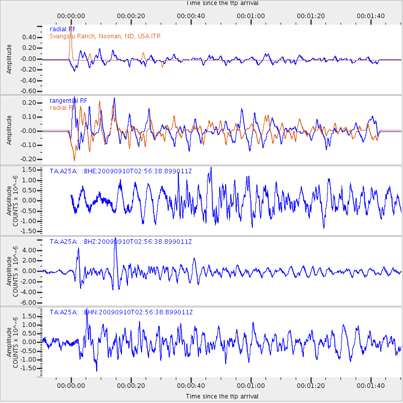
A25A Svangstu Ranch, Noonan, ND, USA - Earthquake Result Viewer
*The percent match for this event was below the threshold and hence no stack was calculated.
| Earthquake location: |
Kuril Islands |
| Earthquake latitude/longitude: |
48.3/154.2 |
| Earthquake time(UTC): |
2009/09/10 (253) 02:46:50 GMT |
| Earthquake Depth: |
36 km |
| Earthquake Magnitude: |
6.0 MB, 5.5 MS, 6.0 MW, 5.8 MW |
| Earthquake Catalog/Contributor: |
WHDF/NEIC |
|
| Network: |
TA USArray Transportable Network (new EarthScope stations) |
| Station: |
A25A Svangstu Ranch, Noonan, ND, USA |
| Lat/Lon: |
48.94 N/103.11 W |
| Elevation: |
584 m |
|
| Distance: |
62.4 deg |
| Az: |
46.532 deg |
| Baz: |
312.718 deg |
| Ray Param: |
$rayparam |
*The percent match for this event was below the threshold and hence was not used in the summary stack. |
|
| Radial Match: |
70.395996 % |
| Radial Bump: |
400 |
| Transverse Match: |
64.12685 % |
| Transverse Bump: |
400 |
| SOD ConfigId: |
2622 |
| Insert Time: |
2010-03-07 06:11:58.524 +0000 |
| GWidth: |
2.5 |
| Max Bumps: |
400 |
| Tol: |
0.001 |
|
Signal To Noise
| Channel | StoN | STA | LTA |
| TA:A25A: :BHZ:20090910T02:56:38.899011Z | 10.127629 | 1.759927E-6 | 1.7377484E-7 |
| TA:A25A: :BHN:20090910T02:56:38.899011Z | 1.048343 | 3.4164603E-7 | 3.2589148E-7 |
| TA:A25A: :BHE:20090910T02:56:38.899011Z | 1.006888 | 4.1255456E-7 | 4.0973234E-7 |
| Arrivals |
| Ps | |
| PpPs | |
| PsPs/PpSs | |


