You are here: Home > Network List > IC - New China Digital Seismograph Network Stations List
> Station HIA Hailar, Neimenggu Autonomous Region, China > Earthquake Result Viewer
HIA Hailar, Neimenggu Autonomous Region, China - Earthquake Result Viewer
*The percent match for this event was below the threshold and hence no stack was calculated.
| Earthquake location: |
Southern Sumatra, Indonesia |
| Earthquake latitude/longitude: |
-3.0/100.9 |
| Earthquake time(UTC): |
2019/12/16 (350) 14:49:16 GMT |
| Earthquake Depth: |
47 km |
| Earthquake Magnitude: |
5.6 Mww |
| Earthquake Catalog/Contributor: |
NEIC PDE/us |
|
| Network: |
IC New China Digital Seismograph Network |
| Station: |
HIA Hailar, Neimenggu Autonomous Region, China |
| Lat/Lon: |
49.27 N/119.74 E |
| Elevation: |
620 m |
|
| Distance: |
54.5 deg |
| Az: |
15.018 deg |
| Baz: |
203.272 deg |
| Ray Param: |
$rayparam |
*The percent match for this event was below the threshold and hence was not used in the summary stack. |
|
| Radial Match: |
55.15325 % |
| Radial Bump: |
400 |
| Transverse Match: |
50.11639 % |
| Transverse Bump: |
400 |
| SOD ConfigId: |
20358551 |
| Insert Time: |
2019-12-30 15:02:00.202 +0000 |
| GWidth: |
2.5 |
| Max Bumps: |
400 |
| Tol: |
0.001 |
|
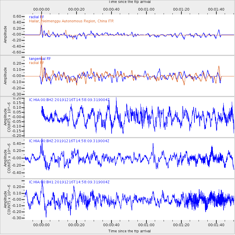
Signal To Noise
| Channel | StoN | STA | LTA |
| IC:HIA:00:BHZ:20191216T14:58:09.319004Z | 3.2402377 | 2.3048112E-7 | 7.1130934E-8 |
| IC:HIA:00:BH1:20191216T14:58:09.319004Z | 2.7892232 | 1.4034273E-7 | 5.0316064E-8 |
| IC:HIA:00:BH2:20191216T14:58:09.319004Z | 1.2301332 | 6.279817E-8 | 5.10499E-8 |
| Arrivals |
| Ps | |
| PpPs | |
| PsPs/PpSs | |


