You are here: Home > Network List > AK - Alaska Regional Network Stations List
> Station BAL Baldy Mountain > Earthquake Result Viewer
BAL Baldy Mountain - Earthquake Result Viewer
| Earthquake location: |
Kuril Islands |
| Earthquake latitude/longitude: |
45.6/148.9 |
| Earthquake time(UTC): |
2020/02/13 (044) 10:33:44 GMT |
| Earthquake Depth: |
144 km |
| Earthquake Magnitude: |
7.0 mww |
| Earthquake Catalog/Contributor: |
NEIC PDE/us |
|
| Network: |
AK Alaska Regional Network |
| Station: |
BAL Baldy Mountain |
| Lat/Lon: |
61.04 N/142.34 W |
| Elevation: |
1341 m |
|
| Distance: |
41.7 deg |
| Az: |
42.959 deg |
| Baz: |
280.774 deg |
| Ray Param: |
0.073093 |
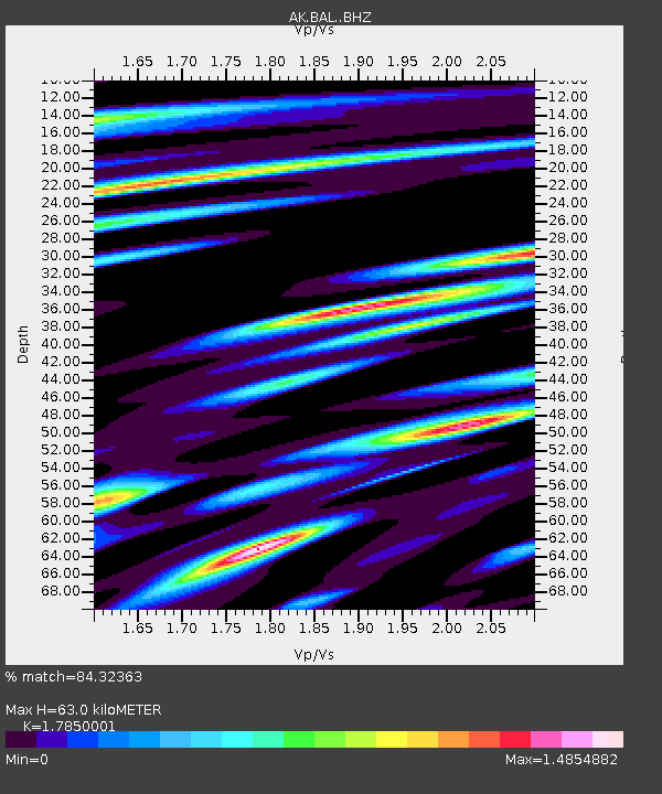
| Estimated Moho Depth: |
63.0 km |
| Estimated Crust Vp/Vs: |
1.79 |
| Assumed Crust Vp: |
6.566 km/s |
| Estimated Crust Vs: |
3.679 km/s |
| Estimated Crust Poisson's Ratio: |
0.27 |
|
| Radial Match: |
84.32363 % |
| Radial Bump: |
399 |
| Transverse Match: |
64.74683 % |
| Transverse Bump: |
400 |
| SOD ConfigId: |
20792311 |
| Insert Time: |
2020-03-05 11:07:29.260 +0000 |
| GWidth: |
2.5 |
| Max Bumps: |
400 |
| Tol: |
0.001 |
|

Signal To Noise
| Channel | StoN | STA | LTA |
| AK:BAL: :BHZ:20200213T10:40:48.847988Z | 6.7259064 | 4.170114E-6 | 6.2000777E-7 |
| AK:BAL: :BHN:20200213T10:40:48.847988Z | 1.9348252 | 7.6975283E-7 | 3.9784103E-7 |
| AK:BAL: :BHE:20200213T10:40:48.847988Z | 4.2862163 | 2.309996E-6 | 5.389359E-7 |
| Arrivals |
| Ps | 8.1 SECOND |
| PpPs | 25 SECOND |
| PsPs/PpSs | 33 SECOND |


