You are here: Home > Network List > IC - New China Digital Seismograph Network Stations List
> Station HIA Hailar, Neimenggu Autonomous Region, China > Earthquake Result Viewer
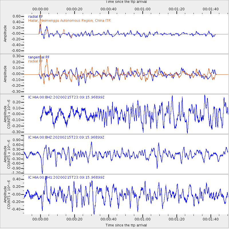
HIA Hailar, Neimenggu Autonomous Region, China - Earthquake Result Viewer
*The percent match for this event was below the threshold and hence no stack was calculated.
| Earthquake location: |
Irian Jaya Region, Indonesia |
| Earthquake latitude/longitude: |
-3.4/131.5 |
| Earthquake time(UTC): |
2020/02/15 (046) 23:00:28 GMT |
| Earthquake Depth: |
19 km |
| Earthquake Magnitude: |
5.6 mww |
| Earthquake Catalog/Contributor: |
NEIC PDE/us |
|
| Network: |
IC New China Digital Seismograph Network |
| Station: |
HIA Hailar, Neimenggu Autonomous Region, China |
| Lat/Lon: |
49.27 N/119.74 E |
| Elevation: |
620 m |
|
| Distance: |
53.4 deg |
| Az: |
350.45 deg |
| Baz: |
165.353 deg |
| Ray Param: |
$rayparam |
*The percent match for this event was below the threshold and hence was not used in the summary stack. |
|
| Radial Match: |
66.040276 % |
| Radial Bump: |
400 |
| Transverse Match: |
61.85775 % |
| Transverse Bump: |
400 |
| SOD ConfigId: |
20831131 |
| Insert Time: |
2020-03-10 20:10:37.157 +0000 |
| GWidth: |
2.5 |
| Max Bumps: |
400 |
| Tol: |
0.001 |
|
Signal To Noise
| Channel | StoN | STA | LTA |
| IC:HIA:00:BHZ:20200215T23:09:15.96899Z | 3.749065 | 4.6178926E-7 | 1.2317452E-7 |
| IC:HIA:00:BH1:20200215T23:09:15.96899Z | 2.988968 | 2.1249046E-7 | 7.1091584E-8 |
| IC:HIA:00:BH2:20200215T23:09:15.96899Z | 0.68859917 | 5.477959E-8 | 7.9552215E-8 |
| Arrivals |
| Ps | |
| PpPs | |
| PsPs/PpSs | |


