You are here: Home > Network List > XL94 - Southern Seirra - Death Valley Stations List
> Station HF00 Harrisburg Flat 00 > Earthquake Result Viewer
HF00 Harrisburg Flat 00 - Earthquake Result Viewer

| Earthquake location: |
Kuril Islands |
| Earthquake latitude/longitude: |
45.7/149.2 |
| Earthquake time(UTC): |
1994/10/16 (289) 05:10:03 GMT |
| Earthquake Depth: |
139 km |
| Earthquake Magnitude: |
6.3 MB, 6.8 UNKNOWN, 6.7 MW |
| Earthquake Catalog/Contributor: |
WHDF/NEIC |
|
| Network: |
XL Southern Seirra - Death Valley |
| Station: |
HF00 Harrisburg Flat 00 |
| Lat/Lon: |
36.36 N/117.14 W |
| Elevation: |
1526 m |
|
| Distance: |
67.3 deg |
| Az: |
60.812 deg |
| Baz: |
310.762 deg |
| Ray Param: |
0.056649674 |
| Estimated Moho Depth: |
29.25 km |
| Estimated Crust Vp/Vs: |
1.83 |
| Assumed Crust Vp: |
6.279 km/s |
| Estimated Crust Vs: |
3.44 km/s |
| Estimated Crust Poisson's Ratio: |
0.29 |
|
| Radial Match: |
86.76371 % |
| Radial Bump: |
339 |
| Transverse Match: |
73.0908 % |
| Transverse Bump: |
400 |
| SOD ConfigId: |
17000 |
| Insert Time: |
2010-03-08 18:06:09.761 +0000 |
| GWidth: |
2.5 |
| Max Bumps: |
400 |
| Tol: |
0.001 |
|
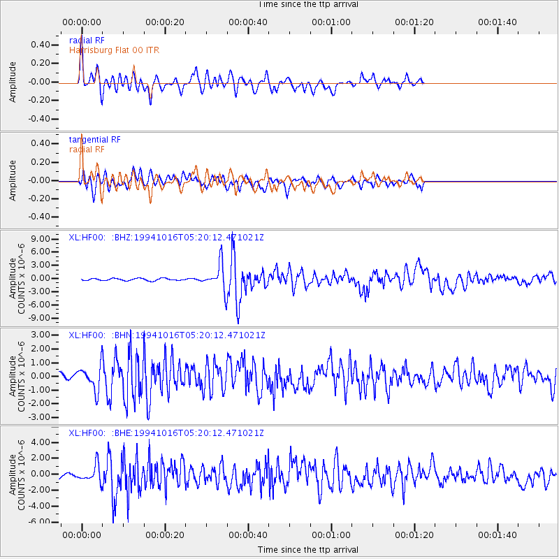
Signal To Noise
| Channel | StoN | STA | LTA |
| XL:HF00: :BHN:19941016T05:20:12.471021Z | 4.3928695 | 9.1392616E-7 | 2.0804764E-7 |
| XL:HF00: :BHE:19941016T05:20:12.471021Z | 2.5616288 | 1.0948289E-6 | 4.273956E-7 |
| XL:HF00: :BHZ:19941016T05:20:12.471021Z | 12.771726 | 3.0848516E-6 | 2.4153758E-7 |
| Arrivals |
| Ps | 4.0 SECOND |
| PpPs | 13 SECOND |
| PsPs/PpSs | 17 SECOND |


