
Station XL HF00 - Harrisburg Flat 00
Network: XL94 - Southern Seirra - Death Valley
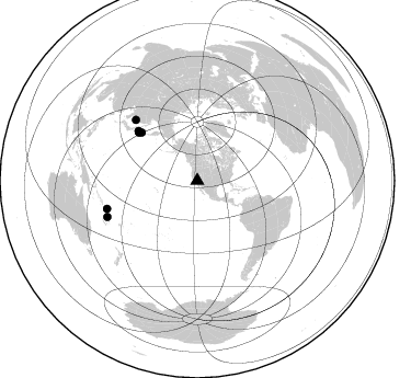
Nearby stations (2 deg radius)
| Station | Name | (Lat, Lon) | Start / End | Elevation |
| HF00 | Harrisburg Flat 00 | (36.36, -117.14) | 1994-06-21 / 1994-12-31 | 1526 m |
| Crust2 Type: | M7,medium thick extended crust, 0.5 km seds. |
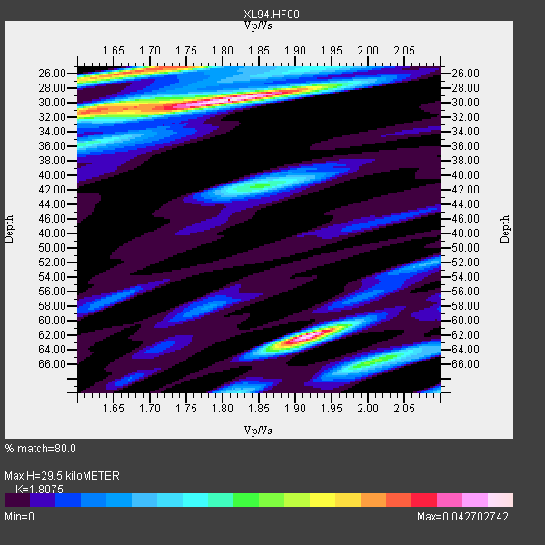
| Thickness Estimate: | 30 km |
| Thickness StdDev: | 15 km |
| Vp/Vs Estimate: | 1.81 |
| Vp/Vs StdDev: | 0.09 |
| Vs Estimate: | 3.474 km/s |
| Poisson's Ratio: | 0.28 |
| Peak Value: | 0.04 |
| Assumed Vp: | 6.279 km/s |
| Ps Weight: | 0.33333334 |
| PpPs Weight: | 0.33333334 |
| PsPs Weight: | 0.33333328 |
| Residual Complexity: | 0.705 |
| Nearby stations H: | +- |
| (2.0 deg) Vp/Vs: | +- |
2 with match > 90% ( 8.695652 %) and 7 with match > 80% ( 30.434782 %) out of 23.
Download stack as xyz text file.
Azimuth Distribution of Events:
Prior Results for this Station
| Study | Thickness | Vp/Vs | Vp | Vs | Poissons Ratio | Extra |
| EARS | 30 km | 1.81 | 6.279 km/s | 3.474 km/s | 0.28 | |
| Crust2.0 | 35 km | 1.78 | 6.279 km/s | 3.533 km/s | 0.27 | M7,medium thick extended crust, 0.5 km seds. |
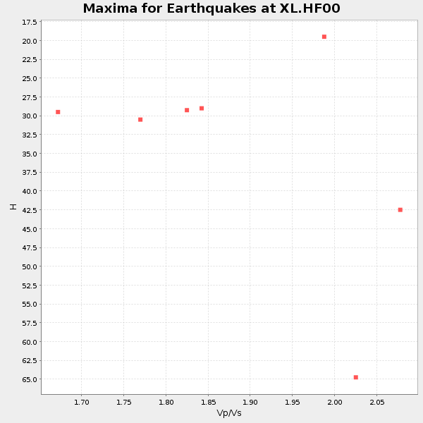
| Global Maxima | 30 km | 1.81 | 6.279 km/s | 3.474 km/s | 0.28 | amp=0.042702742 |
| Local Maxima 1 | 62 km | 1.92 | 6.279 km/s | 3.274 km/s | 0.31 | amp=0.04146766 |
| Local Maxima 2 | 25 km | 1.74 | 6.279 km/s | 3.614 km/s | 0.25 | amp=0.033058453 |
| Local Maxima 3 | 31 km | 1.62 | 6.279 km/s | 3.87 km/s | 0.19 | amp=0.02434416 |
| Local Maxima 4 | 66 km | 2.01 | 6.279 km/s | 3.128 km/s | 0.33 | amp=0.02080167 |
| Predicted Arrivals for vertical incidence (zero ray parameter) | |
| Ps | 3.79 SECOND |
| PpPs | 13.19 SECOND |
| PsPs/PpSs | 16.99 SECOND |
Events Processed for this Station
Download zip of receiver functions as SAC
Plot maxima for each earthquake.
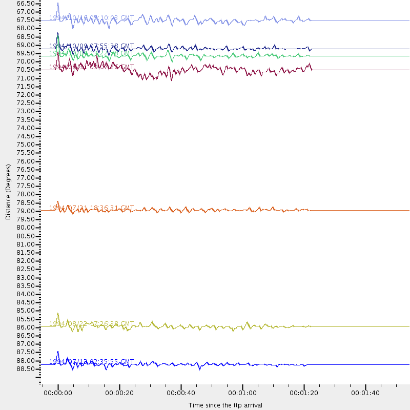
Events Used in the Stack
(7 events)| Radial Match | Distance | Baz | FERegion | Time | Lat/Lon | Depth | Magnitude |
| 95.74089 | 69.5 deg | 309.597 deg | Kuril Islands | 1994/10/04 13:22:58 GMT | (43.7, 147.3) | 33 km | 7.4 MB, 8.1 MS, 8.3 UNKNOWN, 8.2 MW |
| 91.5541 | 88.4 deg | 248.115 deg | Vanuatu Islands | 1994/07/13 02:35:55 GMT | (-16.6, 167.5) | 33 km | 6.3 MB, 7.4 MS, 7.3 UNKNOWN, 7.1 MW |
| 89.28701 | 79.0 deg | 314.736 deg | Primor'ye, Russia | 1994/07/21 18:36:31 GMT | (42.3, 132.9) | 473 km | 6.4 MB, 7.2 UNKNOWN |
| 88.34368 | 86.1 deg | 252.775 deg | Santa Cruz Islands | 1994/08/22 17:26:38 GMT | (-11.5, 166.4) | 148 km | 6.1 MB, 6.4 UNKNOWN, 6.1 MW |
| 87.77368 | 69.1 deg | 309.546 deg | Kuril Islands | 1994/10/09 07:55:38 GMT | (43.9, 147.9) | 23 km | 6.5 MB, 7.0 MS, 6.7 UNKNOWN, 7.3 MW |
| 86.76371 | 67.3 deg | 310.762 deg | Kuril Islands | 1994/10/16 05:10:03 GMT | (45.7, 149.2) | 139 km | 6.3 MB, 6.8 UNKNOWN, 6.7 MW |
| 81.55569 | 70.3 deg | 310.128 deg | Hokkaido, Japan Region | 1994/08/31 09:07:26 GMT | (43.7, 146.0) | 80 km | 5.9 MB, 6.2 UNKNOWN, 6.2 MW |
Losers
(16 events)| Radial Match | Distance | Baz | FERegion | Time | Lat/Lon | Depth | Magnitude | Reason |
| 80.02054 | 89.3 deg | 306.454 deg | Ryukyu Islands, Japan | 1994/09/13 04:28:01 GMT | (29.3, 129.9) | 37 km | 5.8 MB, 6.3 MS, 6.2 UNKNOWN, 6.1 MW | |
| 77.76084 | 67.3 deg | 309.397 deg | East Of Kuril Islands | 1994/08/18 04:42:59 GMT | (44.7, 150.2) | 33 km | 6.1 MB, 6.5 MS, 6.6 UNKNOWN, 6.5 MW | |
| 76.35779 | 67.2 deg | 309.43 deg | East Of Kuril Islands | 1994/08/28 18:37:19 GMT | (44.7, 150.2) | 14 km | 6.0 MB, 6.5 MS, 6.3 UNKNOWN, 6.7 MW | |
| 73.71836 | 69.4 deg | 309.746 deg | Kuril Islands | 1994/10/05 20:39:47 GMT | (43.9, 147.4) | 33 km | 6.2 MB, 5.6 MS, 5.9 UNKNOWN | |
| 63.914017 | 89.0 deg | 247.165 deg | Vanuatu Islands | 1994/10/01 16:35:22 GMT | (-17.8, 167.6) | 33 km | 5.7 MB, 6.5 MS, 6.5 UNKNOWN, 6.5 MW | |
| 63.81433 | 39.0 deg | 310.733 deg | Fox Islands, Aleutian Islands | 1994/07/29 00:17:48 GMT | (52.4, -168.3) | 33 km | 5.9 MB, 5.6 MS, 5.8 UNKNOWN, 5.6 ML | |
| 63.585823 | 75.8 deg | 306.552 deg | Off East Coast Of Honshu, Japan | 1994/08/16 10:09:34 GMT | (37.8, 142.5) | 34 km | 5.8 MB, 5.2 MS, 5.1 UNKNOWN, 5.8 MW | |
| 61.288536 | 47.0 deg | 118.344 deg | Northern Colombia | 1994/09/13 10:01:34 GMT | (7.1, -76.7) | 33 km | 5.8 MB, 5.6 MS | |
| 59.51304 | 79.5 deg | 141.547 deg | Near Coast Of Central Chile | 1994/09/12 06:29:56 GMT | (-31.1, -71.6) | 53 km | 5.8 MB, 6.0 UNKNOWN, 5.5 MD | |
| 56.336575 | 77.4 deg | 238.783 deg | Fiji Islands Region | 1994/07/05 02:59:42 GMT | (-16.3, -177.5) | 413 km | 5.4 MB, 5.8 UNKNOWN | |
| 52.09795 | 88.4 deg | 247.852 deg | Vanuatu Islands | 1994/07/29 07:53:31 GMT | (-16.8, 167.7) | 33 km | 5.5 MB, 5.8 MS, 6.2 UNKNOWN, 5.9 MW | |
| 51.227177 | 76.3 deg | 332.272 deg | East Of Lake Baykal, Russia | 1994/08/21 15:56:01 GMT | (56.7, 117.8) | 33 km | 5.7 MB, 5.8 MS, 6.0 UNKNOWN, 6.0 MW | |
| 49.014236 | 67.8 deg | 127.968 deg | Peru-Bolivia Border Region | 1994/08/08 07:55:39 GMT | (-13.8, -68.4) | 602 km | 5.7 UNKNOWN, 5.4 MB, 5.6 MW | |
| 48.681793 | 80.6 deg | 132.974 deg | Santiago Del Estero Prov., Arg. | 1994/08/19 10:02:51 GMT | (-26.7, -63.4) | 565 km | 6.4 MB, 6.5 UNKNOWN, 6.5 MW | |
| 48.12122 | 78.6 deg | 232.552 deg | Tonga Islands | 1994/08/11 20:42:09 GMT | (-21.5, -173.8) | 33 km | 5.8 MB, 5.5 MS, 5.8 UNKNOWN | |
| 45.38218 | 86.8 deg | 239.459 deg | Southeast Of Loyalty Islands | 1994/09/13 12:22:12 GMT | (-22.3, 174.7) | 33 km | 5.5 MB, 5.4 MS |
