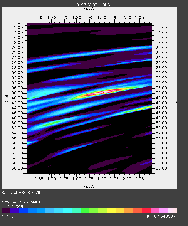
S137 Loma - Earthquake Result Viewer

Earthquake location: Southern Pacific Ocean
Earthquake latitude/longitude: -36.0/-102.5
Earthquake time(UTC): 1997/05/29 (149) 17:02:38 GMT
Earthquake Depth: 10 km
Earthquake Magnitude: 5.6 MB, 6.1 MS, 6.5 UNKNOWN, 6.4 MW
Earthquake Catalog/Contributor: WHDF/NEIC
Network: XL Deep Probe (Archean-Proterozoic)
Station: S137 Loma
Lat/Lon: 39.21 N/108.77 W
Elevation: 1401 m
Distance: 75.0 deg
Az: 354.967 deg
Baz: 174.744 deg
Ray Param: 0.05193886
Estimated Moho Depth: 37.5 km
Estimated Crust Vp/Vs: 1.90
Assumed Crust Vp: 6.291 km/s
Estimated Crust Vs: 3.302 km/s
Estimated Crust Poisson's Ratio: 0.31
Radial Match: 80.00779 %
Radial Bump: 400
Transverse Match: 57.283127 %
Transverse Bump: 400
SOD ConfigId: 6273
Insert Time: 2010-03-08 18:08:02.078 +0000
GWidth: 2.5
Max Bumps: 400
Tol: 0.001

Signal To Noise

ChannelStoNSTALTA
XL:S137: :BHN:19970529T17:13:49.077014Z0.55204255.7975473E-81.0501994E-7
XL:S137: :BHE:19970529T17:13:49.077014Z1.30299851.371069E-71.0522413E-7
XL:S137: :BHZ:19970529T17:13:49.077014Z1.45925999.563806E-86.553874E-8
Arrivals
Ps5.6 SECOND
PpPs17 SECOND
PsPs/PpSs22 SECOND