
Station XL S137 - Loma
Network: XL97 - Deep Probe (Archean-Proterozoic)
Nearby stations (2 deg radius)
| Station | Name | (Lat, Lon) | Start / End | Elevation |
| S137 | Loma | (39.21, -108.77) | 1997-05-12 / 1997-12-31 | 1401 m |
| Crust2 Type: | Q3,orogen/43km no ice, Appalachians, 3 km seds. |
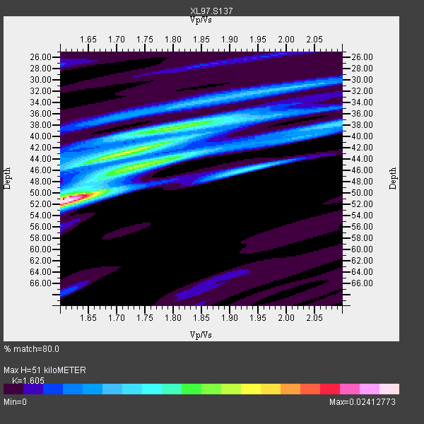
| Thickness Estimate: | 51 km |
| Thickness StdDev: | 5.4 km |
| Vp/Vs Estimate: | 1.61 |
| Vp/Vs StdDev: | 0.11 |
| Vs Estimate: | 3.919 km/s |
| Poisson's Ratio: | 0.18 |
| Peak Value: | 0.02 |
| Assumed Vp: | 6.291 km/s |
| Ps Weight: | 0.33333334 |
| PpPs Weight: | 0.33333334 |
| PsPs Weight: | 0.33333328 |
| Residual Complexity: | 0.781 |
| Nearby stations H: | +- |
| (2.0 deg) Vp/Vs: | +- |
3 with match > 90% ( 11.538462 %) and 9 with match > 80% ( 34.615383 %) out of 26.
Download stack as xyz text file.
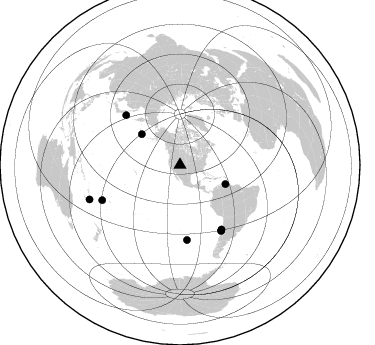
Azimuth Distribution of Events:
Prior Results for this Station
| Study | Thickness | Vp/Vs | Vp | Vs | Poissons Ratio | Extra |
| EARS | 51 km | 1.61 | 6.291 km/s | 3.919 km/s | 0.18 | |
| Crust2.0 | 43 km | 1.76 | 6.291 km/s | 3.577 km/s | 0.26 | Q3,orogen/43km no ice, Appalachians, 3 km seds. |
| Global Maxima | 51 km | 1.61 | 6.291 km/s | 3.919 km/s | 0.18 | amp=0.02412773 |
| Local Maxima 1 | 43 km | 1.72 | 6.291 km/s | 3.668 km/s | 0.24 | amp=0.014482357 |
| Local Maxima 2 | 44 km | 1.77 | 6.291 km/s | 3.559 km/s | 0.26 | amp=0.012407507 |
| Local Maxima 3 | 38 km | 1.82 | 6.291 km/s | 3.466 km/s | 0.28 | amp=0.010239466 |
| Local Maxima 4 | 34 km | 1.82 | 6.291 km/s | 3.466 km/s | 0.28 | amp=0.0059445193 |
| Predicted Arrivals for vertical incidence (zero ray parameter) | |
| Ps | 4.90 SECOND |
| PpPs | 21.12 SECOND |
| PsPs/PpSs | 26.02 SECOND |
Events Processed for this Station
Download zip of receiver functions as SAC
Plot maxima for each earthquake.
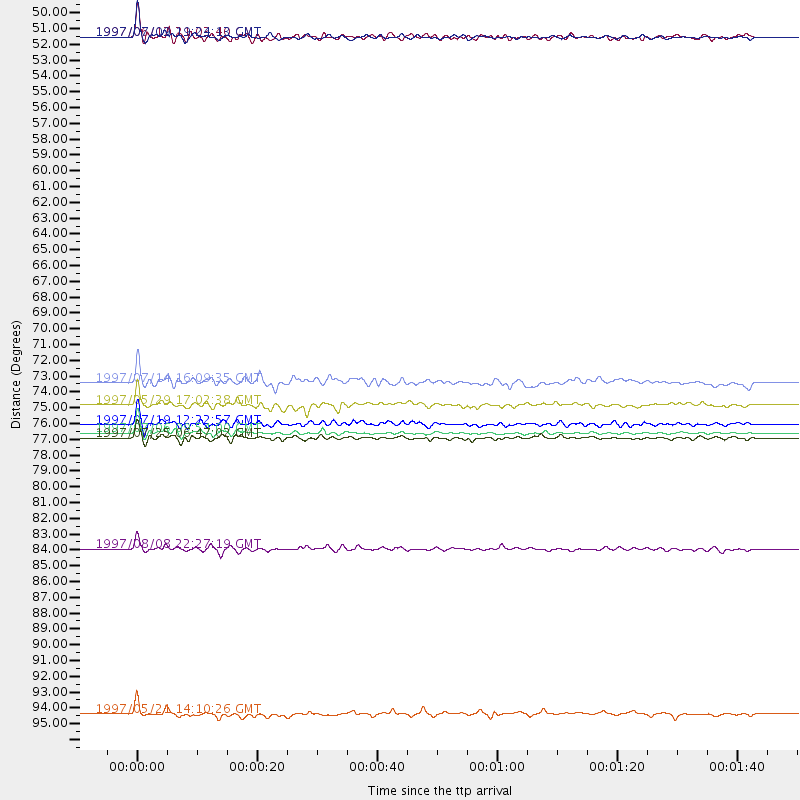
Events Used in the Stack
(9 events)| Radial Match | Distance | Baz | FERegion | Time | Lat/Lon | Depth | Magnitude |
| 95.75091 | 49.3 deg | 112.79 deg | Near Coast Of Venezuela | 1997/07/09 19:24:13 GMT | (10.6, -63.5) | 20 km | 6.2 MB, 6.8 MS, 7.0 UNKNOWN, 6.6 ME |
| 95.39835 | 77.0 deg | 147.707 deg | Near Coast Of Central Chile | 1997/07/06 09:54:00 GMT | (-30.1, -71.9) | 19 km | 5.8 MB, 6.5 MS, 6.8 UNKNOWN, 6.4 ME |
| 93.549095 | 49.3 deg | 308.693 deg | Andreanof Islands, Aleutian Is. | 1997/06/17 21:03:40 GMT | (51.3, -179.3) | 33 km | 6.4 MB, 6.3 MS, 6.4 UNKNOWN, 6.6 ML |
| 87.27638 | 76.4 deg | 147.177 deg | Near Coast Of Central Chile | 1997/07/19 12:22:57 GMT | (-29.3, -71.7) | 26 km | 5.8 MB, 5.5 MS, 5.9 UNKNOWN, 5.8 MW |
| 85.56567 | 77.3 deg | 147.931 deg | Near Coast Of Central Chile | 1997/07/25 06:47:02 GMT | (-30.5, -71.9) | 33 km | 5.6 MB, 5.5 MS, 6.3 UNKNOWN |
| 84.58792 | 85.1 deg | 245.701 deg | Fiji Islands Region | 1997/08/08 22:27:19 GMT | (-15.5, -179.1) | 10 km | 5.7 MB, 6.6 MS, 6.6 UNKNOWN, 6.4 MW |
| 83.92154 | 96.7 deg | 249.212 deg | Vanuatu Islands | 1997/05/21 14:10:26 GMT | (-20.4, 169.3) | 57 km | 5.9 MB, 6.5 MS, 6.7 UNKNOWN, 6.1 ME |
| 83.73685 | 73.5 deg | 312.547 deg | Kuril Islands | 1997/07/14 16:09:35 GMT | (43.2, 146.4) | 33 km | 5.9 MB, 5.8 MS, 6.1 UNKNOWN, 5.8 ME |
| 80.00779 | 75.0 deg | 174.744 deg | Southern Pacific Ocean | 1997/05/29 17:02:38 GMT | (-36.0, -102.5) | 10 km | 5.6 MB, 6.1 MS, 6.5 UNKNOWN, 6.4 MW |
Losers
(17 events)| Radial Match | Distance | Baz | FERegion | Time | Lat/Lon | Depth | Magnitude | Reason |
| 78.35667 | 61.8 deg | 62.141 deg | Azores Islands, Portugal | 1997/06/27 04:39:52 GMT | (38.3, -26.7) | 10 km | 5.6 MB, 5.4 MS, 5.9 UNKNOWN, 5.9 MW | |
| 75.21678 | 89.4 deg | 298.602 deg | Volcano Islands, Japan Region | 1997/07/28 06:46:55 GMT | (22.4, 142.7) | 33 km | 5.7 MB, 5.8 MS, 5.9 UNKNOWN, 5.9 MW | |
| 74.979515 | 77.4 deg | 147.924 deg | Near Coast Of Central Chile | 1997/07/27 05:21:29 GMT | (-30.5, -71.9) | 33 km | 5.6 MB, 5.8 MS, 6.3 UNKNOWN, 6.2 MW | |
| 73.16283 | 77.2 deg | 147.874 deg | Near Coast Of Central Chile | 1997/07/21 23:19:39 GMT | (-30.3, -71.9) | 33 km | 5.2 MB, 5.5 MS, 6.1 UNKNOWN | |
| 70.59825 | 97.1 deg | 234.155 deg | South Of Kermadec Islands | 1997/05/25 23:22:33 GMT | (-32.1, 179.8) | 333 km | 6.2 MB, 7.1 UNKNOWN, 7.0 MW | |
| 62.548347 | 41.8 deg | 308.549 deg | Fox Islands, Aleutian Islands | 1997/07/20 00:30:20 GMT | (52.6, -167.5) | 14 km | 5.6 MB, 5.9 MS, 6.2 UNKNOWN, 6.2 MW | |
| 61.51424 | 80.9 deg | 241.988 deg | Tonga Islands | 1997/05/27 08:00:29 GMT | (-15.2, -173.3) | 14 km | 5.6 MB, 6.3 MS, 6.4 UNKNOWN, 5.7 ME | |
| 60.76276 | 87.9 deg | 314.001 deg | Western Honshu, Japan | 1997/06/25 09:50:12 GMT | (34.4, 131.6) | 10 km | 5.5 MB, 5.6 MS, 5.9 UNKNOWN, 5.8 MW | |
| 59.15401 | 88.5 deg | 299.683 deg | Volcano Islands, Japan Region | 1997/07/08 02:24:07 GMT | (23.8, 142.7) | 33 km | 5.8 MB, 5.6 MS, 5.9 UNKNOWN, 5.8 MW | |
| 53.28031 | 48.8 deg | 308.568 deg | Andreanof Islands, Aleutian Is. | 1997/07/08 12:11:15 GMT | (51.4, -178.6) | 33 km | 5.5 MB, 5.4 MS, 5.8 UNKNOWN, 5.6 ML | |
| 51.5439 | 88.7 deg | 183.761 deg | Southern East Pacific Rise | 1997/06/26 19:21:08 GMT | (-49.7, -114.6) | 10 km | 5.4 MB, 6.0 MS, 6.2 UNKNOWN, 6.1 MW | |
| 50.70372 | 74.7 deg | 179.461 deg | Southern East Pacific Rise | 1997/06/10 21:53:55 GMT | (-35.8, -108.1) | 10 km | 5.8 MB, 6.1 MS, 6.5 UNKNOWN, 5.8 MS | |
| 50.643436 | 75.5 deg | 144.373 deg | Northern Chile | 1997/05/17 02:10:18 GMT | (-27.2, -69.5) | 106 km | 5.5 MB, 5.6 UNKNOWN, 5.5 MW | |
| 48.767006 | 86.5 deg | 243.794 deg | Fiji Islands Region | 1997/06/11 11:53:32 GMT | (-17.8, -178.8) | 573 km | 5.5 UNKNOWN, 4.9 MB | |
| 41.225082 | 96.7 deg | 195.51 deg | Pacific-Antarctic Ridge | 1997/05/27 06:10:31 GMT | (-54.9, -136.2) | 10 km | 5.9 MS, 5.3 MB, 6.1 UNKNOWN, 6.0 MW | |
| 41.13941 | 91.5 deg | 292.434 deg | Mariana Islands | 1997/05/27 15:09:03 GMT | (16.3, 145.4) | 536 km | 5.5 MB, 5.6 UNKNOWN, 5.6 MW | |
| 33.1113 | 95.6 deg | 247.173 deg | Southeast Of Loyalty Islands | 1997/06/09 07:24:12 GMT | (-21.3, 171.5) | 33 km | 5.4 MB, 5.6 MS, 6.0 UNKNOWN, 5.9 MW |
