You are here: Home > Network List > XL97 - Deep Probe (Archean-Proterozoic) Stations List
> Station S240 Stevens Glutch > Earthquake Result Viewer
S240 Stevens Glutch - Earthquake Result Viewer
| Earthquake location: |
South Of Fiji Islands |
| Earthquake latitude/longitude: |
-22.1/-176.8 |
| Earthquake time(UTC): |
1997/10/14 (287) 09:53:18 GMT |
| Earthquake Depth: |
167 km |
| Earthquake Magnitude: |
6.7 MB, 7.7 UNKNOWN, 7.4 ME |
| Earthquake Catalog/Contributor: |
WHDF/NEIC |
|
| Network: |
XL Deep Probe (Archean-Proterozoic) |
| Station: |
S240 Stevens Glutch |
| Lat/Lon: |
38.97 N/107.62 W |
| Elevation: |
2438 m |
|
| Distance: |
88.7 deg |
| Az: |
46.781 deg |
| Baz: |
240.103 deg |
| Ray Param: |
0.042033218 |
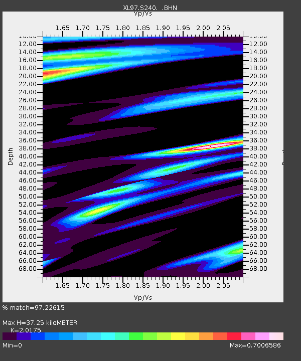
| Estimated Moho Depth: |
37.25 km |
| Estimated Crust Vp/Vs: |
2.02 |
| Assumed Crust Vp: |
6.306 km/s |
| Estimated Crust Vs: |
3.126 km/s |
| Estimated Crust Poisson's Ratio: |
0.34 |
|
| Radial Match: |
97.22615 % |
| Radial Bump: |
338 |
| Transverse Match: |
94.18925 % |
| Transverse Bump: |
400 |
| SOD ConfigId: |
6273 |
| Insert Time: |
2010-03-08 18:08:39.693 +0000 |
| GWidth: |
2.5 |
| Max Bumps: |
400 |
| Tol: |
0.001 |
|
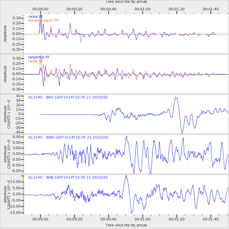
Signal To Noise
| Channel | StoN | STA | LTA |
| XL:S240: :BHN:19971014T10:05:21.302026Z | 3.432534 | 3.9718145E-7 | 1.1571086E-7 |
| XL:S240: :BHE:19971014T10:05:21.302026Z | 1.8801509 | 4.1556385E-7 | 2.2102687E-7 |
| XL:S240: :BHZ:19971014T10:05:21.302026Z | 7.9963107 | 8.672991E-7 | 1.084624E-7 |
| Arrivals |
| Ps | 6.1 SECOND |
| PpPs | 18 SECOND |
| PsPs/PpSs | 24 SECOND |


