
Station XL S240 - Stevens Glutch
Network: XL97 - Deep Probe (Archean-Proterozoic)
Nearby stations (2 deg radius)
| Station | Name | (Lat, Lon) | Start / End | Elevation |
| S240 | Stevens Glutch | (38.97, -107.62) | 1997-08-15 / 1997-12-31 | 2438 m |
| Crust2 Type: | P4,orogen/50km, Urals, Tethian Orogen, Rockies 1 km seds. |
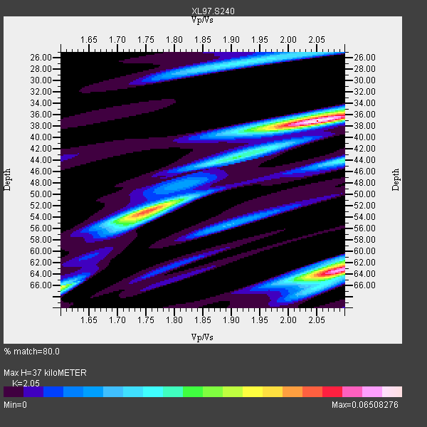
| Thickness Estimate: | 37 km |
| Thickness StdDev: | 11 km |
| Vp/Vs Estimate: | 2.05 |
| Vp/Vs StdDev: | 0.02 |
| Vs Estimate: | 3.076 km/s |
| Poisson's Ratio: | 0.34 |
| Peak Value: | 0.07 |
| Assumed Vp: | 6.306 km/s |
| Ps Weight: | 0.33333334 |
| PpPs Weight: | 0.33333334 |
| PsPs Weight: | 0.33333328 |
| Residual Complexity: | 0.742 |
| Nearby stations H: | +- |
| (2.0 deg) Vp/Vs: | +- |
2 with match > 90% ( 16.666666 %) and 2 with match > 80% ( 16.666666 %) out of 12.
Download stack as xyz text file.
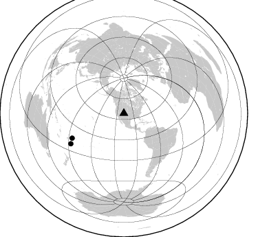
Azimuth Distribution of Events:
Prior Results for this Station
| Study | Thickness | Vp/Vs | Vp | Vs | Poissons Ratio | Extra |
| EARS | 37 km | 2.05 | 6.306 km/s | 3.076 km/s | 0.34 | |
| Crust2.0 | 50 km | 1.76 | 6.306 km/s | 3.584 km/s | 0.26 | P4,orogen/50km, Urals, Tethian Orogen, Rockies 1 km seds. |
| Global Maxima | 37 km | 2.05 | 6.306 km/s | 3.076 km/s | 0.34 | amp=0.06508276 |
| Local Maxima 1 | 63 km | 2.09 | 6.306 km/s | 3.021 km/s | 0.35 | amp=0.060738873 |
| Local Maxima 2 | 53 km | 1.75 | 6.306 km/s | 3.593 km/s | 0.26 | amp=0.048939113 |
| Local Maxima 3 | 44 km | 2.10 | 6.306 km/s | 3.01 km/s | 0.35 | amp=0.026252903 |
| Local Maxima 4 | 66 km | 1.60 | 6.306 km/s | 3.941 km/s | 0.18 | amp=0.026204435 |
| Predicted Arrivals for vertical incidence (zero ray parameter) | |
| Ps | 6.16 SECOND |
| PpPs | 17.90 SECOND |
| PsPs/PpSs | 24.06 SECOND |
Events Processed for this Station
Download zip of receiver functions as SAC
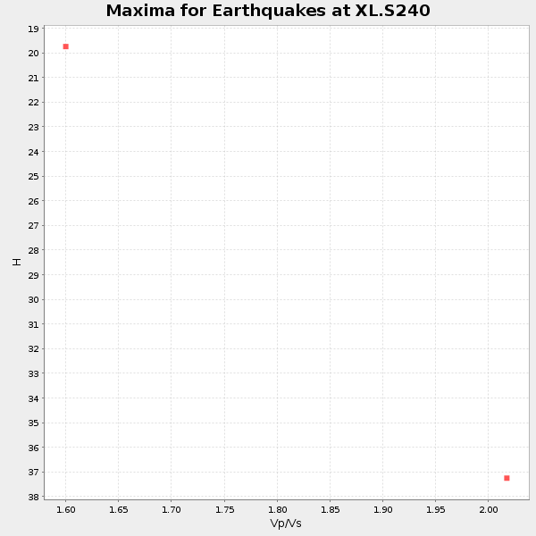
Plot maxima for each earthquake.
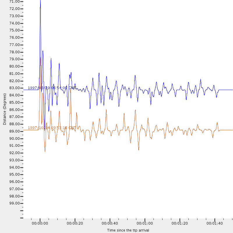
Events Used in the Stack
(2 events)| Radial Match | Distance | Baz | FERegion | Time | Lat/Lon | Depth | Magnitude |
| 97.22615 | 88.7 deg | 240.103 deg | South Of Fiji Islands | 1997/10/14 09:53:18 GMT | (-22.1, -176.8) | 167 km | 6.7 MB, 7.7 UNKNOWN, 7.4 ME |
| 96.530846 | 83.2 deg | 244.308 deg | Tonga Islands | 1997/08/29 06:54:00 GMT | (-15.2, -175.6) | 33 km | 5.6 MB, 6.4 MS, 6.5 UNKNOWN, 6.4 MW |
Losers
(10 events)| Radial Match | Distance | Baz | FERegion | Time | Lat/Lon | Depth | Magnitude | Reason |
| 70.892365 | 91.8 deg | 38.413 deg | Southern Greece | 1997/10/13 13:39:37 GMT | (36.4, 22.1) | 24 km | 6.2 MB, 6.6 MS, 6.7 UNKNOWN, 6.5 MW | |
| 59.83492 | 96.3 deg | 233.91 deg | Kermadec Islands Region | 1997/10/07 13:15:53 GMT | (-31.8, -178.3) | 33 km | 5.5 MB, 5.6 MS | |
| 55.921352 | 93.7 deg | 235.835 deg | Kermadec Islands Region | 1997/09/20 16:11:32 GMT | (-28.7, -177.6) | 30 km | 6.1 MB, 7.0 MS, 7.2 UNKNOWN, 6.7 ME | |
| 52.433414 | 73.5 deg | 314.422 deg | Kuril Islands | 1997/10/22 09:55:47 GMT | (44.7, 146.2) | 154 km | 5.5 MB, 5.6 UNKNOWN, 5.6 MW | |
| 48.647823 | 89.3 deg | 242.297 deg | Fiji Islands Region | 1997/10/17 15:02:00 GMT | (-20.9, -178.8) | 579 km | 5.3 MB, 6.0 UNKNOWN, 6.0 MW | |
| 48.053482 | 51.7 deg | 139.236 deg | Northern Peru | 1997/10/28 06:15:17 GMT | (-4.4, -76.7) | 112 km | 6.6 MB, 6.3 MS, 7.2 UNKNOWN, 6.6 ME | |
| 43.180332 | 80.3 deg | 313.081 deg | Eastern Honshu, Japan | 1997/10/26 19:06:44 GMT | (39.3, 140.5) | 134 km | 5.6 UNKNOWN, 5.2 MB | |
| 38.592255 | 94.3 deg | 240.607 deg | South Of Fiji Islands | 1997/08/26 15:22:09 GMT | (-25.5, 178.3) | 610 km | 5.5 MB, 5.7 UNKNOWN | |
| 37.291893 | 88.5 deg | 241.688 deg | Fiji Islands Region | 1997/08/25 11:59:00 GMT | (-20.8, -177.8) | 394 km | 5.5 UNKNOWN, 5.3 MB | |
| 35.462593 | 94.6 deg | 256.351 deg | Vanuatu Islands | 1997/08/17 20:11:10 GMT | (-13.6, 167.4) | 26 km | 5.4 MB, 6.1 MS, 6.1 UNKNOWN, 6.0 MW |
