You are here: Home > Network List > XL97 - Deep Probe (Archean-Proterozoic) Stations List
> Station S241 Paonia > Earthquake Result Viewer
S241 Paonia - Earthquake Result Viewer
| Earthquake location: |
South Of Fiji Islands |
| Earthquake latitude/longitude: |
-22.1/-176.8 |
| Earthquake time(UTC): |
1997/10/14 (287) 09:53:18 GMT |
| Earthquake Depth: |
167 km |
| Earthquake Magnitude: |
6.7 MB, 7.7 UNKNOWN, 7.4 ME |
| Earthquake Catalog/Contributor: |
WHDF/NEIC |
|
| Network: |
XL Deep Probe (Archean-Proterozoic) |
| Station: |
S241 Paonia |
| Lat/Lon: |
38.84 N/107.54 W |
| Elevation: |
2078 m |
|
| Distance: |
88.7 deg |
| Az: |
46.917 deg |
| Baz: |
240.154 deg |
| Ray Param: |
0.042039957 |
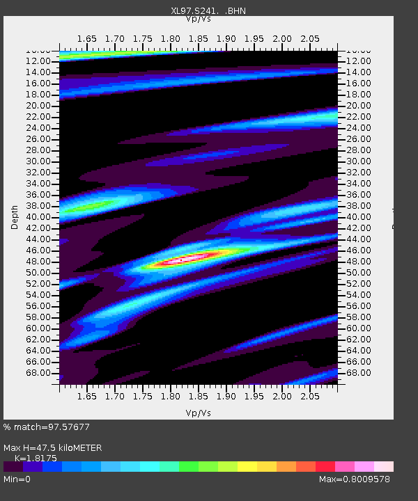
| Estimated Moho Depth: |
47.5 km |
| Estimated Crust Vp/Vs: |
1.82 |
| Assumed Crust Vp: |
6.306 km/s |
| Estimated Crust Vs: |
3.47 km/s |
| Estimated Crust Poisson's Ratio: |
0.28 |
|
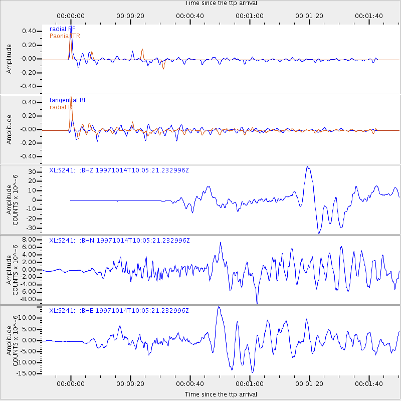
| Radial Match: |
97.57677 % |
| Radial Bump: |
366 |
| Transverse Match: |
95.15729 % |
| Transverse Bump: |
400 |
| SOD ConfigId: |
6273 |
| Insert Time: |
2010-03-08 18:08:49.062 +0000 |
| GWidth: |
2.5 |
| Max Bumps: |
400 |
| Tol: |
0.001 |
|
Signal To Noise
| Channel | StoN | STA | LTA |
| XL:S241: :BHN:19971014T10:05:21.232996Z | 1.520118 | 2.698673E-7 | 1.7753048E-7 |
| XL:S241: :BHE:19971014T10:05:21.232996Z | 1.9266268 | 3.745682E-7 | 1.9441659E-7 |
| XL:S241: :BHZ:19971014T10:05:21.232996Z | 7.034483 | 8.2604237E-7 | 1.174276E-7 |
| Arrivals |
| Ps | 6.3 SECOND |
| PpPs | 21 SECOND |
| PsPs/PpSs | 27 SECOND |


