
Station XL S241 - Paonia
Network: XL97 - Deep Probe (Archean-Proterozoic)
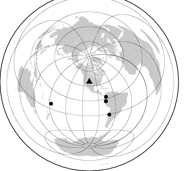
Nearby stations (2 deg radius)
| Station | Name | (Lat, Lon) | Start / End | Elevation |
| S241 | Paonia | (38.84, -107.54) | 1997-08-16 / 1997-12-31 | 2078 m |
| Crust2 Type: | P4,orogen/50km, Urals, Tethian Orogen, Rockies 1 km seds. |
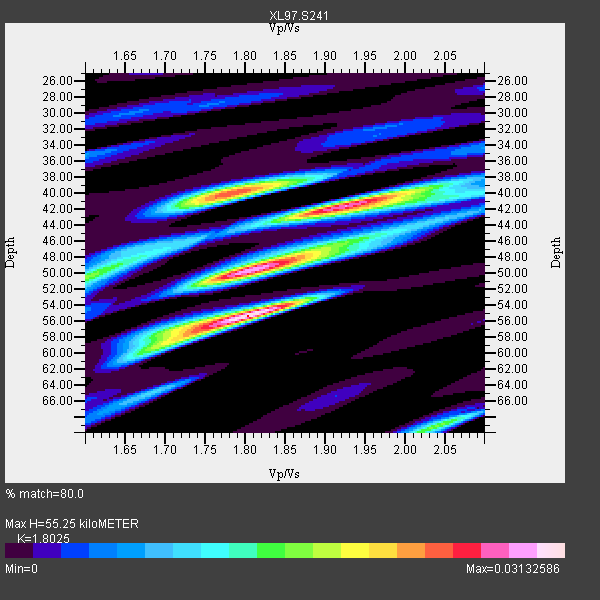
| Thickness Estimate: | 55 km |
| Thickness StdDev: | 6.4 km |
| Vp/Vs Estimate: | 1.80 |
| Vp/Vs StdDev: | 0.06 |
| Vs Estimate: | 3.498 km/s |
| Poisson's Ratio: | 0.28 |
| Peak Value: | 0.03 |
| Assumed Vp: | 6.306 km/s |
| Ps Weight: | 0.33333334 |
| PpPs Weight: | 0.33333334 |
| PsPs Weight: | 0.33333328 |
| Residual Complexity: | 0.841 |
| Nearby stations H: | +- |
| (2.0 deg) Vp/Vs: | +- |
3 with match > 90% ( 20.0 %) and 4 with match > 80% ( 26.666666 %) out of 15.
Download stack as xyz text file.
Azimuth Distribution of Events:
Prior Results for this Station
| Study | Thickness | Vp/Vs | Vp | Vs | Poissons Ratio | Extra |
| EARS | 55 km | 1.80 | 6.306 km/s | 3.498 km/s | 0.28 | |
| Crust2.0 | 50 km | 1.76 | 6.306 km/s | 3.584 km/s | 0.26 | P4,orogen/50km, Urals, Tethian Orogen, Rockies 1 km seds. |
| Global Maxima | 55 km | 1.80 | 6.306 km/s | 3.498 km/s | 0.28 | amp=0.03132586 |
| Local Maxima 1 | 50 km | 1.81 | 6.306 km/s | 3.494 km/s | 0.28 | amp=0.028840067 |
| Local Maxima 2 | 40 km | 1.78 | 6.306 km/s | 3.548 km/s | 0.27 | amp=0.024793634 |
| Local Maxima 3 | 42 km | 1.91 | 6.306 km/s | 3.297 km/s | 0.31 | amp=0.02370684 |
| Local Maxima 4 | 69 km | 2.04 | 6.306 km/s | 3.091 km/s | 0.34 | amp=0.016133001 |
| Predicted Arrivals for vertical incidence (zero ray parameter) | |
| Ps | 7.03 SECOND |
| PpPs | 24.55 SECOND |
| PsPs/PpSs | 31.59 SECOND |
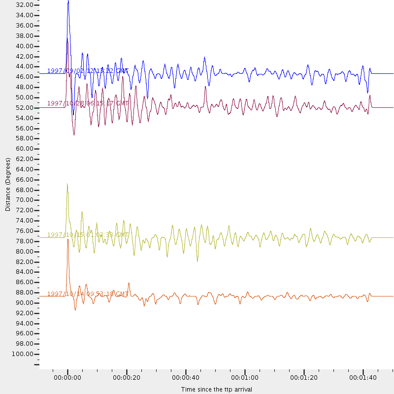
Events Processed for this Station
Download zip of receiver functions as SAC
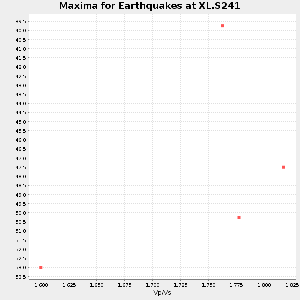
Plot maxima for each earthquake.
Events Used in the Stack
(4 events)| Radial Match | Distance | Baz | FERegion | Time | Lat/Lon | Depth | Magnitude |
| 97.57677 | 88.7 deg | 240.154 deg | South Of Fiji Islands | 1997/10/14 09:53:18 GMT | (-22.1, -176.8) | 167 km | 6.7 MB, 7.7 UNKNOWN, 7.4 ME |
| 91.49494 | 77.2 deg | 148.541 deg | Near Coast Of Central Chile | 1997/10/15 01:03:33 GMT | (-30.9, -71.2) | 58 km | 6.8 MB, 6.8 MS, 7.3 UNKNOWN, 7.1 MW |
| 90.031746 | 51.6 deg | 139.257 deg | Northern Peru | 1997/10/28 06:15:17 GMT | (-4.4, -76.7) | 112 km | 6.6 MB, 6.3 MS, 7.2 UNKNOWN, 6.6 ME |
| 84.06485 | 45.3 deg | 132.26 deg | Colombia | 1997/09/02 12:13:22 GMT | (3.8, -75.7) | 199 km | 6.5 MB, 6.8 UNKNOWN, 6.4 ME |
Losers
(11 events)| Radial Match | Distance | Baz | FERegion | Time | Lat/Lon | Depth | Magnitude | Reason |
| 88.91422 | 93.7 deg | 235.874 deg | Kermadec Islands Region | 1997/09/20 16:11:32 GMT | (-28.7, -177.6) | 30 km | 6.1 MB, 7.0 MS, 7.2 UNKNOWN, 6.7 ME | |
| 86.56894 | 86.8 deg | 303.484 deg | Bonin Islands, Japan Region | 1997/11/05 23:45:30 GMT | (27.9, 142.6) | 10 km | 5.4 MB, 5.6 MS, 6.0 UNKNOWN, 5.9 MW | |
| 79.29832 | 49.3 deg | 309.0 deg | Andreanof Islands, Aleutian Is. | 1997/10/15 03:11:09 GMT | (51.4, -177.9) | 22 km | 5.7 MB, 6.1 MS, 6.3 UNKNOWN, 5.6 ML | |
| 71.73067 | 95.0 deg | 239.845 deg | South Of Fiji Islands | 1997/09/04 04:23:37 GMT | (-26.6, 178.3) | 625 km | 6.3 MB, 6.8 UNKNOWN, 6.5 ME | |
| 57.49359 | 95.6 deg | 234.828 deg | Kermadec Islands, New Zealand | 1997/10/27 09:32:59 GMT | (-30.8, -178.5) | 33 km | 5.5 MB, 5.4 MS | |
| 57.36699 | 87.3 deg | 239.253 deg | Tonga Islands | 1997/10/19 15:53:38 GMT | (-21.8, -175.0) | 33 km | 5.6 MB, 5.9 MS | |
| 57.269512 | 91.9 deg | 38.465 deg | Southern Greece | 1997/10/13 13:39:37 GMT | (36.4, 22.1) | 24 km | 6.2 MB, 6.6 MS, 6.7 UNKNOWN, 6.5 MW | |
| 56.989677 | 73.6 deg | 314.483 deg | Kuril Islands | 1997/10/22 09:55:47 GMT | (44.7, 146.2) | 154 km | 5.5 MB, 5.6 UNKNOWN, 5.6 MW | |
| 48.55487 | 78.0 deg | 320.496 deg | Primor'ye, Russia | 1997/10/01 06:05:48 GMT | (46.2, 136.1) | 416 km | 5.5 UNKNOWN, 5.2 MB | |
| 42.22002 | 95.2 deg | 194.7 deg | Pacific-Antarctic Ridge | 1997/10/26 13:55:33 GMT | (-54.1, -133.0) | 10 km | 5.5 MS, 5.1 MB | |
| 28.529467 | 89.3 deg | 242.346 deg | Fiji Islands Region | 1997/10/17 15:02:00 GMT | (-20.9, -178.8) | 579 km | 5.3 MB, 6.0 UNKNOWN, 6.0 MW |
