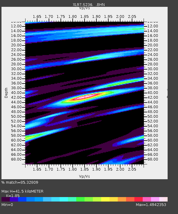
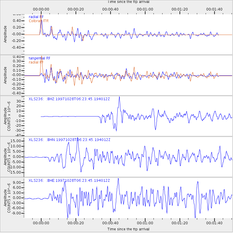
S236 Colbran - Earthquake Result Viewer

Earthquake location: Northern Peru
Earthquake latitude/longitude: -4.4/-76.7
Earthquake time(UTC): 1997/10/28 (301) 06:15:17 GMT
Earthquake Depth: 112 km
Earthquake Magnitude: 6.6 MB, 6.3 MS, 7.2 UNKNOWN, 6.6 ME
Earthquake Catalog/Contributor: WHDF/NEIC
Network: XL Deep Probe (Archean-Proterozoic)
Station: S236 Colbran
Lat/Lon: 39.20 N/107.95 W
Elevation: 2080 m
Distance: 52.1 deg
Az: 329.246 deg
Baz: 138.991 deg
Ray Param: 0.06663702
Estimated Moho Depth: 41.5 km
Estimated Crust Vp/Vs: 1.85
Assumed Crust Vp: 6.306 km/s
Estimated Crust Vs: 3.409 km/s
Estimated Crust Poisson's Ratio: 0.29
Radial Match: 85.32809 %
Radial Bump: 400
Transverse Match: 85.989265 %
Transverse Bump: 400
SOD ConfigId: 6273
Insert Time: 2010-03-08 18:09:17.150 +0000
GWidth: 2.5
Max Bumps: 400
Tol: 0.001

Signal To Noise

ChannelStoNSTALTA
XL:S236: :BHN:19971028T06:23:45.194012Z3.25802351.0537747E-63.2343985E-7
XL:S236: :BHE:19971028T06:23:45.194012Z3.4549355.866825E-71.6981E-7
XL:S236: :BHZ:19971028T06:23:45.194012Z15.5969663.7104287E-62.3789427E-7
Arrivals
Ps5.9 SECOND
PpPs18 SECOND
PsPs/PpSs24 SECOND