
Station XL S236 - Colbran
Network: XL97 - Deep Probe (Archean-Proterozoic)
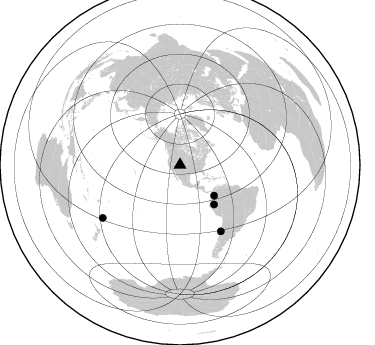
Nearby stations (2 deg radius)
| Station | Name | (Lat, Lon) | Start / End | Elevation |
| S236 | Colbran | (39.20, -107.95) | 1997-08-14 / 1997-12-31 | 2080 m |
| Crust2 Type: | P4,orogen/50km, Urals, Tethian Orogen, Rockies 1 km seds. |
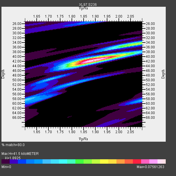
| Thickness Estimate: | 42 km |
| Thickness StdDev: | 4.0 km |
| Vp/Vs Estimate: | 1.89 |
| Vp/Vs StdDev: | 0.07 |
| Vs Estimate: | 3.332 km/s |
| Poisson's Ratio: | 0.31 |
| Peak Value: | 0.08 |
| Assumed Vp: | 6.306 km/s |
| Ps Weight: | 0.33333334 |
| PpPs Weight: | 0.33333334 |
| PsPs Weight: | 0.33333328 |
| Residual Complexity: | 0.450 |
| Nearby stations H: | +- |
| (2.0 deg) Vp/Vs: | +- |
0 with match > 90% ( 0.0 %) and 4 with match > 80% ( 33.333332 %) out of 12.
Download stack as xyz text file.
Azimuth Distribution of Events:
Prior Results for this Station
| Study | Thickness | Vp/Vs | Vp | Vs | Poissons Ratio | Extra |
| EARS | 42 km | 1.89 | 6.306 km/s | 3.332 km/s | 0.31 | |
| Crust2.0 | 50 km | 1.76 | 6.306 km/s | 3.584 km/s | 0.26 | P4,orogen/50km, Urals, Tethian Orogen, Rockies 1 km seds. |
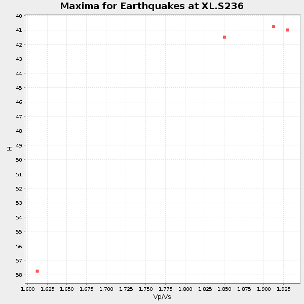
| Global Maxima | 42 km | 1.89 | 6.306 km/s | 3.332 km/s | 0.31 | amp=0.07561263 |
| Local Maxima 1 | 34 km | 2.10 | 6.306 km/s | 3.006 km/s | 0.35 | amp=0.035873096 |
| Local Maxima 2 | 41 km | 1.87 | 6.306 km/s | 3.381 km/s | 0.30 | amp=0.032536607 |
| Local Maxima 3 | 58 km | 2.10 | 6.306 km/s | 3.006 km/s | 0.35 | amp=0.02100693 |
| Local Maxima 4 | 51 km | 1.80 | 6.306 km/s | 3.498 km/s | 0.28 | amp=0.0195059 |
| Predicted Arrivals for vertical incidence (zero ray parameter) | |
| Ps | 5.87 SECOND |
| PpPs | 19.04 SECOND |
| PsPs/PpSs | 24.91 SECOND |
Events Processed for this Station
Download zip of receiver functions as SAC
Plot maxima for each earthquake.
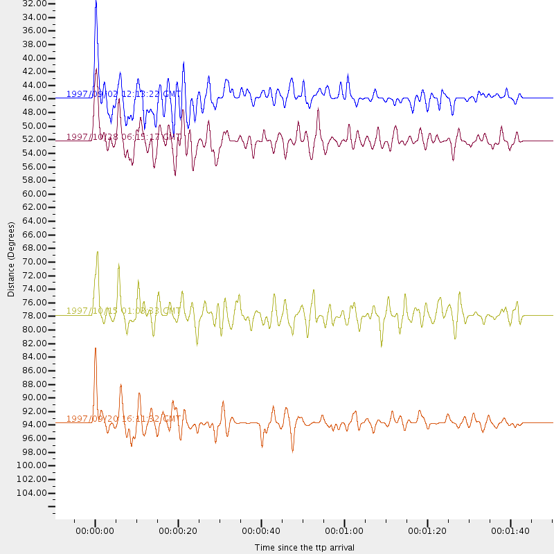
Events Used in the Stack
(4 events)| Radial Match | Distance | Baz | FERegion | Time | Lat/Lon | Depth | Magnitude |
| 85.32809 | 52.1 deg | 138.991 deg | Northern Peru | 1997/10/28 06:15:17 GMT | (-4.4, -76.7) | 112 km | 6.6 MB, 6.3 MS, 7.2 UNKNOWN, 6.6 ME |
| 83.04743 | 77.7 deg | 148.264 deg | Near Coast Of Central Chile | 1997/10/15 01:03:33 GMT | (-30.9, -71.2) | 58 km | 6.8 MB, 6.8 MS, 7.3 UNKNOWN, 7.1 MW |
| 82.38992 | 93.6 deg | 235.647 deg | Kermadec Islands Region | 1997/09/20 16:11:32 GMT | (-28.7, -177.6) | 30 km | 6.1 MB, 7.0 MS, 7.2 UNKNOWN, 6.7 ME |
| 80.58794 | 45.7 deg | 132.05 deg | Colombia | 1997/09/02 12:13:22 GMT | (3.8, -75.7) | 199 km | 6.5 MB, 6.8 UNKNOWN, 6.4 ME |
Losers
(8 events)| Radial Match | Distance | Baz | FERegion | Time | Lat/Lon | Depth | Magnitude | Reason |
| 78.56194 | 43.4 deg | 176.729 deg | Central East Pacific Rise | 1997/08/15 07:37:49 GMT | (-4.4, -105.7) | 10 km | 5.3 MB, 5.8 MS, 6.2 UNKNOWN, 6.1 MW | |
| 52.955887 | 95.6 deg | 234.617 deg | Kermadec Islands, New Zealand | 1997/10/27 09:32:59 GMT | (-30.8, -178.5) | 33 km | 5.5 MB, 5.4 MS | |
| 39.39314 | 95.7 deg | 191.94 deg | Pacific-Antarctic Ridge | 1997/09/03 06:22:44 GMT | (-55.2, -129.0) | 10 km | 5.1 MB, 6.0 MS, 6.1 UNKNOWN, 6.0 MW | |
| 36.215797 | 71.6 deg | 141.646 deg | Northern Chile | 1997/09/28 23:13:13 GMT | (-22.4, -68.4) | 107 km | 5.7 MB, 5.6 UNKNOWN, 5.6 MW | |
| 35.256966 | 88.4 deg | 241.47 deg | Fiji Islands Region | 1997/08/25 11:59:00 GMT | (-20.8, -177.8) | 394 km | 5.5 UNKNOWN, 5.3 MB | |
| 31.140425 | 94.2 deg | 240.422 deg | South Of Fiji Islands | 1997/08/26 15:22:09 GMT | (-25.5, 178.3) | 610 km | 5.5 MB, 5.7 UNKNOWN | |
| 29.699995 | 95.4 deg | 194.48 deg | Pacific-Antarctic Ridge | 1997/10/26 13:55:33 GMT | (-54.1, -133.0) | 10 km | 5.5 MS, 5.1 MB | |
| 25.921938 | 79.9 deg | 312.873 deg | Eastern Honshu, Japan | 1997/10/26 19:06:44 GMT | (39.3, 140.5) | 134 km | 5.6 UNKNOWN, 5.2 MB |
