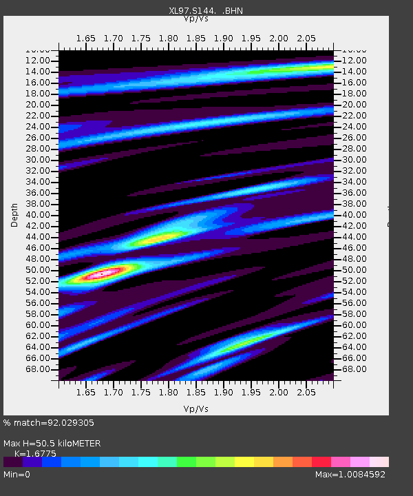
S144 Uncompahgre Forest - Earthquake Result Viewer

Earthquake location: Near Coast Of Venezuela
Earthquake latitude/longitude: 10.6/-63.5
Earthquake time(UTC): 1997/07/09 (190) 19:24:13 GMT
Earthquake Depth: 20 km
Earthquake Magnitude: 6.2 MB, 6.8 MS, 7.0 UNKNOWN, 6.6 ME
Earthquake Catalog/Contributor: WHDF/NEIC
Network: XL Deep Probe (Archean-Proterozoic)
Station: S144 Uncompahgre Forest
Lat/Lon: 38.60 N/108.68 W
Elevation: 2779 m
Distance: 49.0 deg
Az: 312.534 deg
Baz: 112.384 deg
Ray Param: 0.06897452
Estimated Moho Depth: 50.5 km
Estimated Crust Vp/Vs: 1.68
Assumed Crust Vp: 6.291 km/s
Estimated Crust Vs: 3.75 km/s
Estimated Crust Poisson's Ratio: 0.22
Radial Match: 92.029305 %
Radial Bump: 400
Transverse Match: 86.12794 %
Transverse Bump: 400
SOD ConfigId: 6273
Insert Time: 2010-03-08 18:09:29.966 +0000
GWidth: 2.5
Max Bumps: 400
Tol: 0.001

Signal To Noise

ChannelStoNSTALTA
XL:S144: :BHN:19970709T19:32:27.333002Z1.04118611.7018323E-71.6345129E-7
XL:S144: :BHE:19970709T19:32:27.333002Z1.16874841.8834572E-71.6115165E-7
XL:S144: :BHZ:19970709T19:32:27.333002Z1.93356061.5543976E-78.039043E-8
Arrivals
Ps5.8 SECOND
PpPs20 SECOND
PsPs/PpSs26 SECOND