
Station XL S144 - Uncompahgre Forest
Network: XL97 - Deep Probe (Archean-Proterozoic)
Nearby stations (2 deg radius)
| Station | Name | (Lat, Lon) | Start / End | Elevation |
| S144 | Uncompahgre Forest | (38.60, -108.68) | 1997-06-02 / 1997-12-31 | 2779 m |
| Crust2 Type: | Q3,orogen/43km no ice, Appalachians, 3 km seds. |
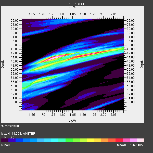
| Thickness Estimate: | 44 km |
| Thickness StdDev: | 4.6 km |
| Vp/Vs Estimate: | 1.76 |
| Vp/Vs StdDev: | 0.08 |
| Vs Estimate: | 3.574 km/s |
| Poisson's Ratio: | 0.26 |
| Peak Value: | 0.03 |
| Assumed Vp: | 6.291 km/s |
| Ps Weight: | 0.33333334 |
| PpPs Weight: | 0.33333334 |
| PsPs Weight: | 0.33333328 |
| Residual Complexity: | 0.757 |
| Nearby stations H: | +- |
| (2.0 deg) Vp/Vs: | +- |
3 with match > 90% ( 20.0 %) and 5 with match > 80% ( 33.333332 %) out of 15.
Download stack as xyz text file.
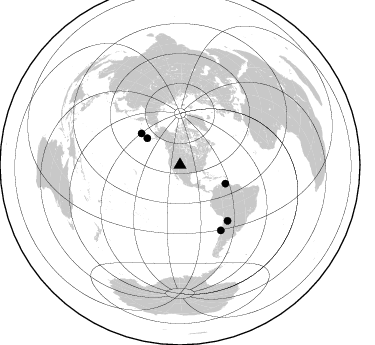
Azimuth Distribution of Events:
Prior Results for this Station
| Study | Thickness | Vp/Vs | Vp | Vs | Poissons Ratio | Extra |
| EARS | 44 km | 1.76 | 6.291 km/s | 3.574 km/s | 0.26 | |
| Crust2.0 | 43 km | 1.76 | 6.291 km/s | 3.577 km/s | 0.26 | Q3,orogen/43km no ice, Appalachians, 3 km seds. |
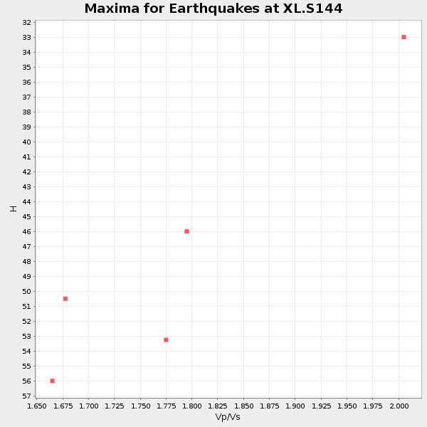
| Global Maxima | 44 km | 1.76 | 6.291 km/s | 3.574 km/s | 0.26 | amp=0.031346485 |
| Local Maxima 1 | 45 km | 1.84 | 6.291 km/s | 3.428 km/s | 0.29 | amp=0.023908146 |
| Local Maxima 2 | 42 km | 1.95 | 6.291 km/s | 3.222 km/s | 0.32 | amp=0.017217033 |
| Local Maxima 3 | 59 km | 1.60 | 6.291 km/s | 3.932 km/s | 0.18 | amp=0.015647326 |
| Local Maxima 4 | 56 km | 1.66 | 6.291 km/s | 3.784 km/s | 0.22 | amp=0.014031478 |
| Predicted Arrivals for vertical incidence (zero ray parameter) | |
| Ps | 5.35 SECOND |
| PpPs | 19.41 SECOND |
| PsPs/PpSs | 24.76 SECOND |
Events Processed for this Station
Download zip of receiver functions as SAC
Plot maxima for each earthquake.
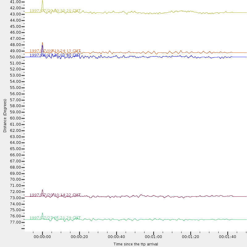
Events Used in the Stack
(5 events)| Radial Match | Distance | Baz | FERegion | Time | Lat/Lon | Depth | Magnitude |
| 93.66063 | 49.7 deg | 309.114 deg | Andreanof Islands, Aleutian Is. | 1997/06/17 21:03:40 GMT | (51.3, -179.3) | 33 km | 6.4 MB, 6.3 MS, 6.4 UNKNOWN, 6.6 ML |
| 93.433464 | 76.9 deg | 147.919 deg | Near Coast Of Central Chile | 1997/07/27 05:21:29 GMT | (-30.5, -71.9) | 33 km | 5.6 MB, 5.8 MS, 6.3 UNKNOWN, 6.2 MW |
| 92.029305 | 49.0 deg | 112.384 deg | Near Coast Of Venezuela | 1997/07/09 19:24:13 GMT | (10.6, -63.5) | 20 km | 6.2 MB, 6.8 MS, 7.0 UNKNOWN, 6.6 ME |
| 86.34113 | 73.0 deg | 139.492 deg | Jujuy Province, Argentina | 1997/07/20 10:14:22 GMT | (-23.0, -66.3) | 256 km | 5.7 MB, 6.1 UNKNOWN, 5.7 ME |
| 82.72262 | 42.3 deg | 309.08 deg | Fox Islands, Aleutian Islands | 1997/07/20 00:30:20 GMT | (52.6, -167.5) | 14 km | 5.6 MB, 5.9 MS, 6.2 UNKNOWN, 6.2 MW |
Losers
(10 events)| Radial Match | Distance | Baz | FERegion | Time | Lat/Lon | Depth | Magnitude | Reason |
| 79.401665 | 76.8 deg | 147.926 deg | Near Coast Of Central Chile | 1997/07/25 06:47:02 GMT | (-30.5, -71.9) | 33 km | 5.6 MB, 5.5 MS, 6.3 UNKNOWN | |
| 76.25299 | 75.9 deg | 147.166 deg | Near Coast Of Central Chile | 1997/07/19 12:22:57 GMT | (-29.3, -71.7) | 26 km | 5.8 MB, 5.5 MS, 5.9 UNKNOWN, 5.8 MW | |
| 60.931877 | 88.8 deg | 299.75 deg | Volcano Islands, Japan Region | 1997/07/08 02:24:07 GMT | (23.8, 142.7) | 33 km | 5.8 MB, 5.6 MS, 5.9 UNKNOWN, 5.8 MW | |
| 57.475166 | 89.8 deg | 298.661 deg | Volcano Islands, Japan Region | 1997/07/28 06:46:55 GMT | (22.4, 142.7) | 33 km | 5.7 MB, 5.8 MS, 5.9 UNKNOWN, 5.9 MW | |
| 52.220097 | 76.7 deg | 147.869 deg | Near Coast Of Central Chile | 1997/07/21 23:19:39 GMT | (-30.3, -71.9) | 33 km | 5.2 MB, 5.5 MS, 6.1 UNKNOWN | |
| 52.217888 | 74.1 deg | 179.535 deg | Southern East Pacific Rise | 1997/06/10 21:53:55 GMT | (-35.8, -108.1) | 10 km | 5.8 MB, 6.1 MS, 6.5 UNKNOWN, 5.8 MS | |
| 51.034336 | 95.5 deg | 247.172 deg | Southeast Of Loyalty Islands | 1997/06/09 07:24:12 GMT | (-21.3, 171.5) | 33 km | 5.4 MB, 5.6 MS, 6.0 UNKNOWN, 5.9 MW | |
| 30.698372 | 89.5 deg | 238.542 deg | South Of Fiji Islands | 1997/06/11 09:29:23 GMT | (-24.0, -177.5) | 164 km | 5.9 UNKNOWN, 5.4 MB, 5.5 MB | |
| 30.187056 | 92.8 deg | 38.862 deg | Central Mediterranean Sea | 1997/07/27 10:07:52 GMT | (35.6, 21.1) | 33 km | 5.5 MB, 4.8 MS, 5.6 UNKNOWN, 5.2 ML | |
| 24.914555 | 86.3 deg | 243.886 deg | Fiji Islands Region | 1997/06/11 11:53:32 GMT | (-17.8, -178.8) | 573 km | 5.5 UNKNOWN, 4.9 MB |
