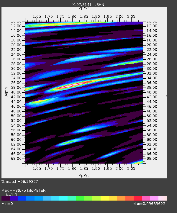
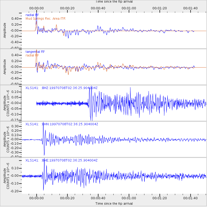
S141 Mud Springs Rec. Area - Earthquake Result Viewer

Earthquake location: Volcano Islands, Japan Region
Earthquake latitude/longitude: 23.8/142.7
Earthquake time(UTC): 1997/07/08 (189) 02:24:07 GMT
Earthquake Depth: 33 km
Earthquake Magnitude: 5.8 MB, 5.6 MS, 5.9 UNKNOWN, 5.8 MW
Earthquake Catalog/Contributor: WHDF/NEIC
Network: XL Deep Probe (Archean-Proterozoic)
Station: S141 Mud Springs Rec. Area
Lat/Lon: 38.88 N/108.76 W
Elevation: 2615 m
Distance: 88.7 deg
Az: 47.746 deg
Baz: 299.698 deg
Ray Param: 0.042383686
Estimated Moho Depth: 36.75 km
Estimated Crust Vp/Vs: 1.80
Assumed Crust Vp: 6.291 km/s
Estimated Crust Vs: 3.495 km/s
Estimated Crust Poisson's Ratio: 0.28
Radial Match: 96.19327 %
Radial Bump: 400
Transverse Match: 91.23255 %
Transverse Bump: 400
SOD ConfigId: 4480
Insert Time: 2010-03-08 18:10:11.577 +0000
GWidth: 2.5
Max Bumps: 400
Tol: 0.001

Signal To Noise

ChannelStoNSTALTA
XL:S141: :BHN:19970708T02:36:25.904004Z31.5183431.00549634E-73.1901943E-9
XL:S141: :BHE:19970708T02:36:25.904004Z4.9389714.3087365E-88.723956E-9
XL:S141: :BHZ:19970708T02:36:25.904004Z3.66398173.294063E-88.9903915E-9
Arrivals
Ps4.8 SECOND
PpPs16 SECOND
PsPs/PpSs21 SECOND