
Station XL S141 - Mud Springs Rec. Area
Network: XL97 - Deep Probe (Archean-Proterozoic)
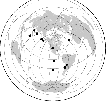
Nearby stations (2 deg radius)
| Station | Name | (Lat, Lon) | Start / End | Elevation |
| S141 | Mud Springs Rec. Area | (38.88, -108.76) | 1997-06-05 / 1997-12-31 | 2615 m |
| Crust2 Type: | Q3,orogen/43km no ice, Appalachians, 3 km seds. |
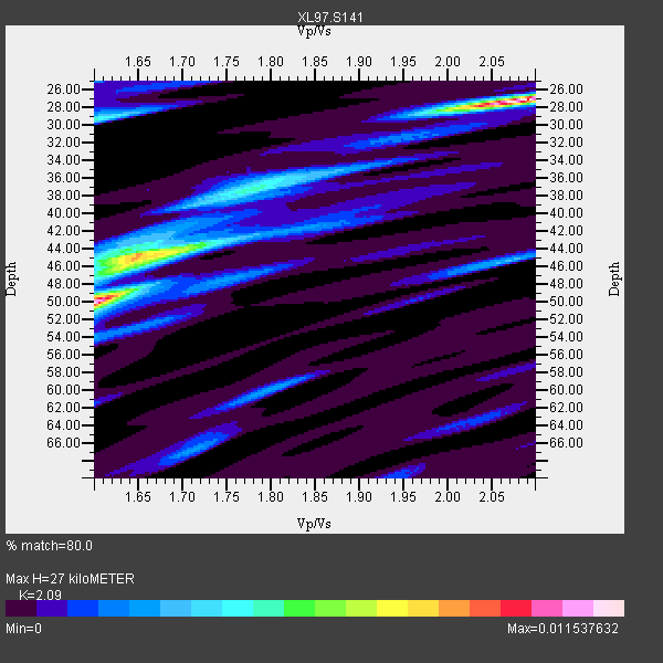
| Thickness Estimate: | 27 km |
| Thickness StdDev: | 11 km |
| Vp/Vs Estimate: | 2.09 |
| Vp/Vs StdDev: | 0.22 |
| Vs Estimate: | 3.01 km/s |
| Poisson's Ratio: | 0.35 |
| Peak Value: | 0.01 |
| Assumed Vp: | 6.291 km/s |
| Ps Weight: | 0.33333334 |
| PpPs Weight: | 0.33333334 |
| PsPs Weight: | 0.33333328 |
| Residual Complexity: | 0.785 |
| Nearby stations H: | +- |
| (2.0 deg) Vp/Vs: | +- |
11 with match > 90% ( 57.894737 %) and 16 with match > 80% ( 84.210526 %) out of 19.
Download stack as xyz text file.
Azimuth Distribution of Events:
Prior Results for this Station
| Study | Thickness | Vp/Vs | Vp | Vs | Poissons Ratio | Extra |
| EARS | 27 km | 2.09 | 6.291 km/s | 3.01 km/s | 0.35 | |
| Crust2.0 | 43 km | 1.76 | 6.291 km/s | 3.577 km/s | 0.26 | Q3,orogen/43km no ice, Appalachians, 3 km seds. |
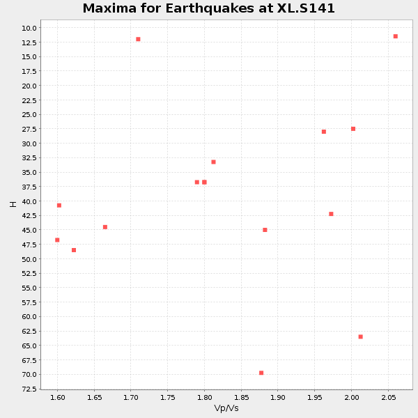
| Global Maxima | 27 km | 2.09 | 6.291 km/s | 3.01 km/s | 0.35 | amp=0.011537632 |
| Local Maxima 1 | 50 km | 1.60 | 6.291 km/s | 3.932 km/s | 0.18 | amp=0.010122493 |
| Local Maxima 2 | 44 km | 1.70 | 6.291 km/s | 3.711 km/s | 0.23 | amp=0.00549508 |
| Local Maxima 3 | 29 km | 1.60 | 6.291 km/s | 3.932 km/s | 0.18 | amp=0.004861543 |
| Local Maxima 4 | 38 km | 1.76 | 6.291 km/s | 3.564 km/s | 0.26 | amp=0.003796676 |
| Predicted Arrivals for vertical incidence (zero ray parameter) | |
| Ps | 4.68 SECOND |
| PpPs | 13.26 SECOND |
| PsPs/PpSs | 17.94 SECOND |
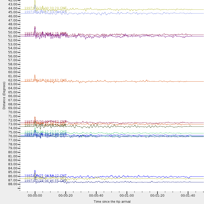
Events Processed for this Station
Download zip of receiver functions as SAC
Plot maxima for each earthquake.
Events Used in the Stack
(16 events)| Radial Match | Distance | Baz | FERegion | Time | Lat/Lon | Depth | Magnitude |
| 97.50866 | 76.1 deg | 147.145 deg | Near Coast Of Central Chile | 1997/07/19 12:22:57 GMT | (-29.3, -71.7) | 26 km | 5.8 MB, 5.5 MS, 5.9 UNKNOWN, 5.8 MW |
| 96.727684 | 77.1 deg | 147.895 deg | Near Coast Of Central Chile | 1997/07/27 05:21:29 GMT | (-30.5, -71.9) | 33 km | 5.6 MB, 5.8 MS, 6.3 UNKNOWN, 6.2 MW |
| 96.21179 | 76.7 deg | 147.677 deg | Near Coast Of Central Chile | 1997/07/06 09:54:00 GMT | (-30.1, -71.9) | 19 km | 5.8 MB, 6.5 MS, 6.8 UNKNOWN, 6.4 ME |
| 96.19327 | 88.7 deg | 299.698 deg | Volcano Islands, Japan Region | 1997/07/08 02:24:07 GMT | (23.8, 142.7) | 33 km | 5.8 MB, 5.6 MS, 5.9 UNKNOWN, 5.8 MW |
| 95.42459 | 73.7 deg | 312.625 deg | Kuril Islands | 1997/07/14 16:09:35 GMT | (43.2, 146.4) | 33 km | 5.9 MB, 5.8 MS, 6.1 UNKNOWN, 5.8 ME |
| 95.102104 | 89.6 deg | 298.613 deg | Volcano Islands, Japan Region | 1997/07/28 06:46:55 GMT | (22.4, 142.7) | 33 km | 5.7 MB, 5.8 MS, 5.9 UNKNOWN, 5.9 MW |
| 94.97016 | 73.3 deg | 139.487 deg | Jujuy Province, Argentina | 1997/07/20 10:14:22 GMT | (-23.0, -66.3) | 256 km | 5.7 MB, 6.1 UNKNOWN, 5.7 ME |
| 94.87168 | 77.1 deg | 147.902 deg | Near Coast Of Central Chile | 1997/07/25 06:47:02 GMT | (-30.5, -71.9) | 33 km | 5.6 MB, 5.5 MS, 6.3 UNKNOWN |
| 93.23423 | 76.9 deg | 147.845 deg | Near Coast Of Central Chile | 1997/07/21 23:19:39 GMT | (-30.3, -71.9) | 33 km | 5.2 MB, 5.5 MS, 6.1 UNKNOWN |
| 92.49629 | 42.1 deg | 308.835 deg | Fox Islands, Aleutian Islands | 1997/07/20 00:30:20 GMT | (52.6, -167.5) | 14 km | 5.6 MB, 5.9 MS, 6.2 UNKNOWN, 6.2 MW |
| 92.04107 | 74.3 deg | 179.472 deg | Southern East Pacific Rise | 1997/06/10 21:53:55 GMT | (-35.8, -108.1) | 10 km | 5.8 MB, 6.1 MS, 6.5 UNKNOWN, 5.8 MS |
| 88.20107 | 61.9 deg | 61.991 deg | Azores Islands, Portugal | 1997/06/27 04:39:52 GMT | (38.3, -26.7) | 10 km | 5.6 MB, 5.4 MS, 5.9 UNKNOWN, 5.9 MW |
| 86.33409 | 43.1 deg | 175.532 deg | Central East Pacific Rise | 1997/08/15 07:37:49 GMT | (-4.4, -105.7) | 10 km | 5.3 MB, 5.8 MS, 6.2 UNKNOWN, 6.1 MW |
| 84.90793 | 49.5 deg | 308.915 deg | Andreanof Islands, Aleutian Is. | 1997/06/17 21:03:40 GMT | (51.3, -179.3) | 33 km | 6.4 MB, 6.3 MS, 6.4 UNKNOWN, 6.6 ML |
| 83.27833 | 88.1 deg | 314.018 deg | Western Honshu, Japan | 1997/06/25 09:50:12 GMT | (34.4, 131.6) | 10 km | 5.5 MB, 5.6 MS, 5.9 UNKNOWN, 5.8 MW |
| 82.98462 | 49.0 deg | 308.795 deg | Andreanof Islands, Aleutian Is. | 1997/07/08 12:11:15 GMT | (51.4, -178.6) | 33 km | 5.5 MB, 5.4 MS, 5.8 UNKNOWN, 5.6 ML |
Losers
(3 events)| Radial Match | Distance | Baz | FERegion | Time | Lat/Lon | Depth | Magnitude | Reason |
| 71.924576 | 92.6 deg | 38.805 deg | Central Mediterranean Sea | 1997/07/27 10:07:52 GMT | (35.6, 21.1) | 33 km | 5.5 MB, 4.8 MS, 5.6 UNKNOWN, 5.2 ML | |
| 70.955574 | 86.4 deg | 243.822 deg | Fiji Islands Region | 1997/06/11 11:53:32 GMT | (-17.8, -178.8) | 573 km | 5.5 UNKNOWN, 4.9 MB | |
| 61.297977 | 89.6 deg | 238.493 deg | South Of Fiji Islands | 1997/06/11 09:29:23 GMT | (-24.0, -177.5) | 164 km | 5.9 UNKNOWN, 5.4 MB, 5.5 MB |
