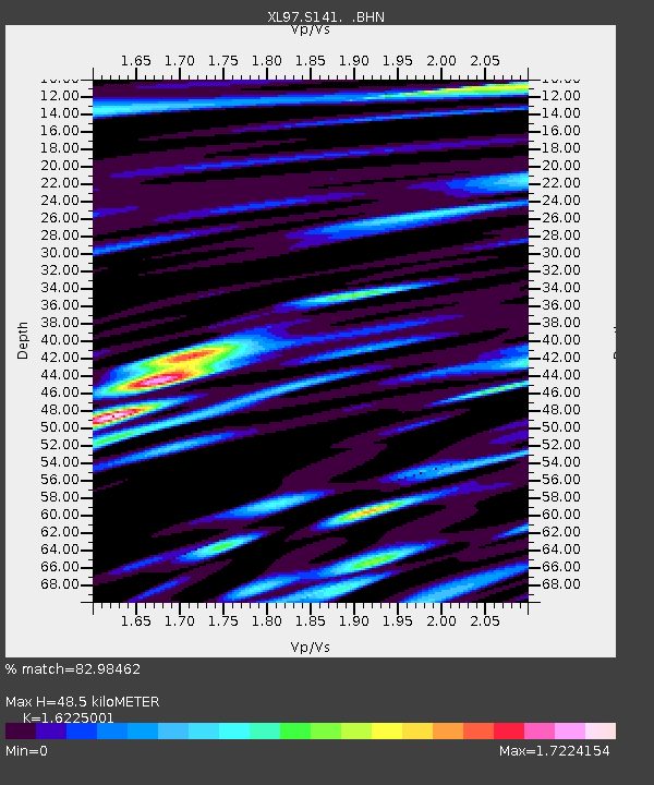
S141 Mud Springs Rec. Area - Earthquake Result Viewer
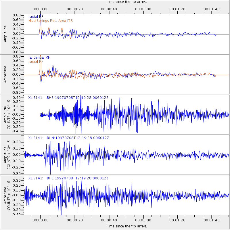
Earthquake location: Andreanof Islands, Aleutian Is.
Earthquake latitude/longitude: 51.4/-178.6
Earthquake time(UTC): 1997/07/08 (189) 12:11:15 GMT
Earthquake Depth: 33 km
Earthquake Magnitude: 5.5 MB, 5.4 MS, 5.8 UNKNOWN, 5.6 ML
Earthquake Catalog/Contributor: WHDF/NEIC
Network: XL Deep Probe (Archean-Proterozoic)
Station: S141 Mud Springs Rec. Area
Lat/Lon: 38.88 N/108.76 W
Elevation: 2615 m
Distance: 49.0 deg
Az: 76.04 deg
Baz: 308.795 deg
Ray Param: 0.068910606
Estimated Moho Depth: 48.5 km
Estimated Crust Vp/Vs: 1.62
Assumed Crust Vp: 6.291 km/s
Estimated Crust Vs: 3.877 km/s
Estimated Crust Poisson's Ratio: 0.19
Radial Match: 82.98462 %
Radial Bump: 400
Transverse Match: 69.33824 %
Transverse Bump: 400
SOD ConfigId: 4480
Insert Time: 2010-03-08 18:10:12.355 +0000
GWidth: 2.5
Max Bumps: 400
Tol: 0.001

Signal To Noise

ChannelStoNSTALTA
XL:S141: :BHN:19970708T12:19:28.006012Z3.2449885.7856532E-81.7829505E-8
XL:S141: :BHE:19970708T12:19:28.006012Z1.0576467.1246426E-86.73632E-8
XL:S141: :BHZ:19970708T12:19:28.006012Z0.75518229.853185E-81.3047428E-7
Arrivals
Ps5.1 SECOND
PpPs19 SECOND
PsPs/PpSs24 SECOND