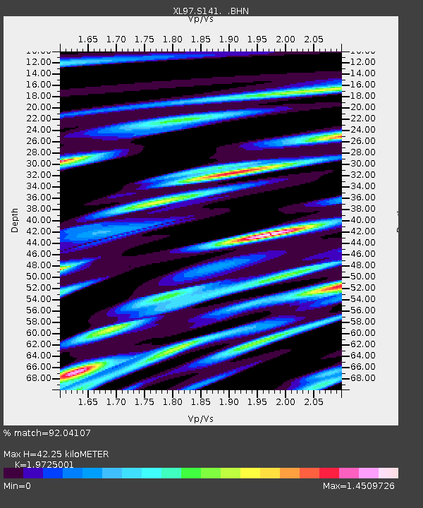
S141 Mud Springs Rec. Area - Earthquake Result Viewer

Earthquake location: Southern East Pacific Rise
Earthquake latitude/longitude: -35.8/-108.1
Earthquake time(UTC): 1997/06/10 (161) 21:53:55 GMT
Earthquake Depth: 10 km
Earthquake Magnitude: 5.8 MB, 6.1 MS, 6.5 UNKNOWN, 5.8 MS
Earthquake Catalog/Contributor: WHDF/NEIC
Network: XL Deep Probe (Archean-Proterozoic)
Station: S141 Mud Springs Rec. Area
Lat/Lon: 38.88 N/108.76 W
Elevation: 2615 m
Distance: 74.3 deg
Az: 359.493 deg
Baz: 179.472 deg
Ray Param: 0.05240623
Estimated Moho Depth: 42.25 km
Estimated Crust Vp/Vs: 1.97
Assumed Crust Vp: 6.291 km/s
Estimated Crust Vs: 3.189 km/s
Estimated Crust Poisson's Ratio: 0.33
Radial Match: 92.04107 %
Radial Bump: 400
Transverse Match: 81.63235 %
Transverse Bump: 400
SOD ConfigId: 6273
Insert Time: 2010-03-08 18:10:15.522 +0000
GWidth: 2.5
Max Bumps: 400
Tol: 0.001

Signal To Noise

ChannelStoNSTALTA
XL:S141: :BHN:19970610T22:05:01.304016Z0.69774382.393268E-83.4300097E-8
XL:S141: :BHE:19970610T22:05:01.304016Z0.362957541.5397218E-84.242154E-8
XL:S141: :BHZ:19970610T22:05:01.304016Z4.44700343.9653834E-88.916979E-9
Arrivals
Ps6.7 SECOND
PpPs19 SECOND
PsPs/PpSs26 SECOND