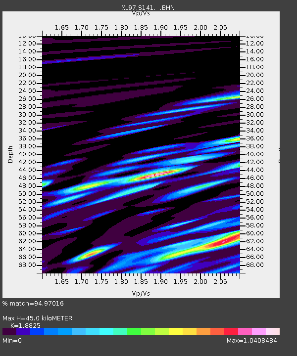
S141 Mud Springs Rec. Area - Earthquake Result Viewer
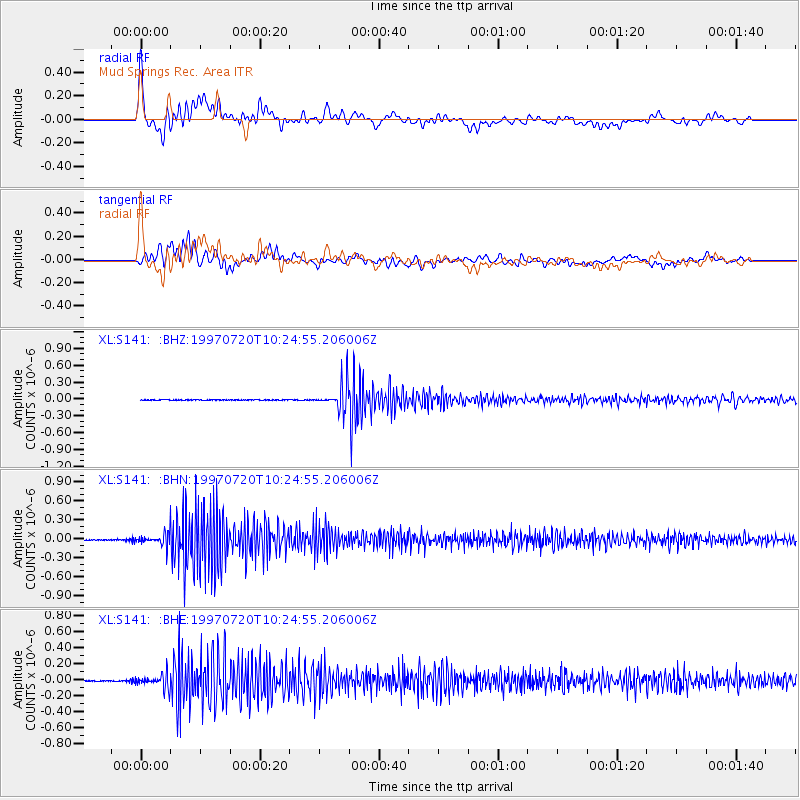
Earthquake location: Jujuy Province, Argentina
Earthquake latitude/longitude: -23.0/-66.3
Earthquake time(UTC): 1997/07/20 (201) 10:14:22 GMT
Earthquake Depth: 256 km
Earthquake Magnitude: 5.7 MB, 6.1 UNKNOWN, 5.7 ME
Earthquake Catalog/Contributor: WHDF/NEIC
Network: XL Deep Probe (Archean-Proterozoic)
Station: S141 Mud Springs Rec. Area
Lat/Lon: 38.88 N/108.76 W
Elevation: 2615 m
Distance: 73.3 deg
Az: 326.621 deg
Baz: 139.487 deg
Ray Param: 0.052402284
Estimated Moho Depth: 45.0 km
Estimated Crust Vp/Vs: 1.88
Assumed Crust Vp: 6.291 km/s
Estimated Crust Vs: 3.342 km/s
Estimated Crust Poisson's Ratio: 0.30
Radial Match: 94.97016 %
Radial Bump: 400
Transverse Match: 91.04801 %
Transverse Bump: 400
SOD ConfigId: 6273
Insert Time: 2010-03-08 18:10:19.513 +0000
GWidth: 2.5
Max Bumps: 400
Tol: 0.001

Signal To Noise

ChannelStoNSTALTA
XL:S141: :BHN:19970720T10:24:55.206006Z7.8795241.10090966E-71.3971778E-8
XL:S141: :BHE:19970720T10:24:55.206006Z13.7039998.659359E-86.3188557E-9
XL:S141: :BHZ:19970720T10:24:55.206006Z91.137982.452677E-72.691169E-9
Arrivals
Ps6.5 SECOND
PpPs20 SECOND
PsPs/PpSs27 SECOND