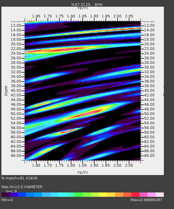
S125 Martins Gap - Earthquake Result Viewer

Earthquake location: Andreanof Islands, Aleutian Is.
Earthquake latitude/longitude: 51.3/-179.3
Earthquake time(UTC): 1997/06/17 (168) 21:03:40 GMT
Earthquake Depth: 33 km
Earthquake Magnitude: 6.4 MB, 6.3 MS, 6.4 UNKNOWN, 6.6 ML
Earthquake Catalog/Contributor: WHDF/NEIC
Network: XL Deep Probe (Archean-Proterozoic)
Station: S125 Martins Gap
Lat/Lon: 40.26 N/108.77 W
Elevation: 1849 m
Distance: 48.6 deg
Az: 74.114 deg
Baz: 307.978 deg
Ray Param: 0.06917726
Estimated Moho Depth: 10.0 km
Estimated Crust Vp/Vs: 1.60
Assumed Crust Vp: 6.207 km/s
Estimated Crust Vs: 3.879 km/s
Estimated Crust Poisson's Ratio: 0.18
Radial Match: 91.43638 %
Radial Bump: 400
Transverse Match: 88.9723 %
Transverse Bump: 400
SOD ConfigId: 6273
Insert Time: 2010-03-08 18:10:46.309 +0000
GWidth: 2.5
Max Bumps: 400
Tol: 0.001

Signal To Noise

ChannelStoNSTALTA
XL:S125: :BHN:19970617T21:11:50.218005Z14.79346752.075689E-61.4031119E-7
XL:S125: :BHE:19970617T21:11:50.218005Z5.8085131.9860865E-63.419268E-7
XL:S125: :BHZ:19970617T21:11:50.218005Z97.8214655.510319E-65.633037E-8
Arrivals
Ps1.0 SECOND
PpPs3.9 SECOND
PsPs/PpSs5.0 SECOND