
Station XL S125 - Martins Gap
Network: XL97 - Deep Probe (Archean-Proterozoic)
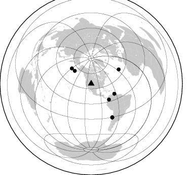
Nearby stations (2 deg radius)
| Station | Name | (Lat, Lon) | Start / End | Elevation |
| S125 | Martins Gap | (40.26, -108.77) | 1997-05-05 / 1997-12-31 | 1849 m |
| Crust2 Type: | Q4,orogen/43km no ice, Tethian Belt, 5 km seds. |
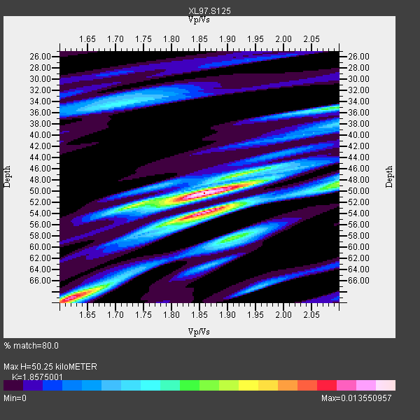
| Thickness Estimate: | 50 km |
| Thickness StdDev: | 8.2 km |
| Vp/Vs Estimate: | 1.86 |
| Vp/Vs StdDev: | 0.11 |
| Vs Estimate: | 3.342 km/s |
| Poisson's Ratio: | 0.30 |
| Peak Value: | 0.01 |
| Assumed Vp: | 6.207 km/s |
| Ps Weight: | 0.33333334 |
| PpPs Weight: | 0.33333334 |
| PsPs Weight: | 0.33333328 |
| Residual Complexity: | 0.731 |
| Nearby stations H: | 48 km +- 2.1 km |
| (2.0 deg) Vp/Vs: | 1.90 +- 0.06 |
4 with match > 90% ( 15.384615 %) and 8 with match > 80% ( 30.76923 %) out of 26.
Download stack as xyz text file.
Azimuth Distribution of Events:
Prior Results for this Station
| Study | Thickness | Vp/Vs | Vp | Vs | Poissons Ratio | Extra |
| EARS | 50 km | 1.86 | 6.207 km/s | 3.342 km/s | 0.30 | |
| Crust2.0 | 43 km | 1.76 | 6.207 km/s | 3.535 km/s | 0.26 | Q4,orogen/43km no ice, Tethian Belt, 5 km seds. |
| Global Maxima | 50 km | 1.86 | 6.207 km/s | 3.342 km/s | 0.30 | amp=0.013550957 |
| Local Maxima 1 | 54 km | 1.87 | 6.207 km/s | 3.328 km/s | 0.30 | amp=0.011821169 |
| Local Maxima 2 | 69 km | 1.62 | 6.207 km/s | 3.837 km/s | 0.19 | amp=0.011460216 |
| Local Maxima 3 | 48 km | 2.10 | 6.207 km/s | 2.959 km/s | 0.35 | amp=0.0075470456 |
| Local Maxima 4 | 35 km | 2.09 | 6.207 km/s | 2.966 km/s | 0.35 | amp=0.0067677125 |
| Predicted Arrivals for vertical incidence (zero ray parameter) | |
| Ps | 6.94 SECOND |
| PpPs | 23.13 SECOND |
| PsPs/PpSs | 30.08 SECOND |
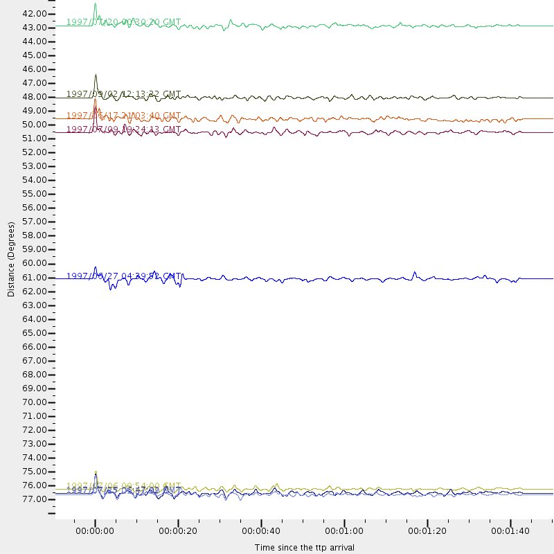
Events Processed for this Station
Download zip of receiver functions as SAC
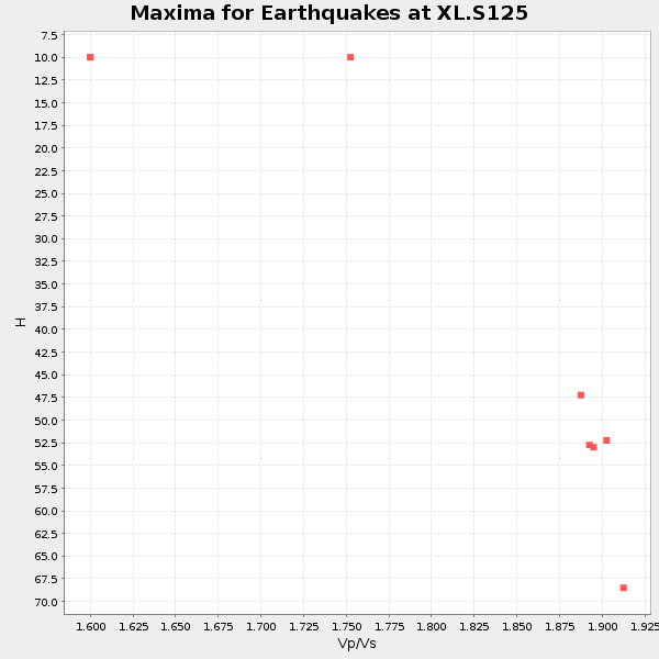
Plot maxima for each earthquake.
Events Used in the Stack
(8 events)| Radial Match | Distance | Baz | FERegion | Time | Lat/Lon | Depth | Magnitude |
| 93.38965 | 77.9 deg | 147.835 deg | Near Coast Of Central Chile | 1997/07/06 09:54:00 GMT | (-30.1, -71.9) | 19 km | 5.8 MB, 6.5 MS, 6.8 UNKNOWN, 6.4 ME |
| 93.3232 | 49.7 deg | 113.617 deg | Near Coast Of Venezuela | 1997/07/09 19:24:13 GMT | (10.6, -63.5) | 20 km | 6.2 MB, 6.8 MS, 7.0 UNKNOWN, 6.6 ME |
| 93.036964 | 78.3 deg | 148.047 deg | Near Coast Of Central Chile | 1997/07/27 05:21:29 GMT | (-30.5, -71.9) | 33 km | 5.6 MB, 5.8 MS, 6.3 UNKNOWN, 6.2 MW |
| 91.43638 | 48.6 deg | 307.978 deg | Andreanof Islands, Aleutian Is. | 1997/06/17 21:03:40 GMT | (51.3, -179.3) | 33 km | 6.4 MB, 6.3 MS, 6.4 UNKNOWN, 6.6 ML |
| 87.5371 | 41.2 deg | 307.618 deg | Fox Islands, Aleutian Islands | 1997/07/20 00:30:20 GMT | (52.6, -167.5) | 14 km | 5.6 MB, 5.9 MS, 6.2 UNKNOWN, 6.2 MW |
| 87.47715 | 61.3 deg | 62.646 deg | Azores Islands, Portugal | 1997/06/27 04:39:52 GMT | (38.3, -26.7) | 10 km | 5.6 MB, 5.4 MS, 5.9 UNKNOWN, 5.9 MW |
| 86.3122 | 78.2 deg | 148.055 deg | Near Coast Of Central Chile | 1997/07/25 06:47:02 GMT | (-30.5, -71.9) | 33 km | 5.6 MB, 5.5 MS, 6.3 UNKNOWN |
| 81.41445 | 46.9 deg | 131.881 deg | Colombia | 1997/09/02 12:13:22 GMT | (3.8, -75.7) | 199 km | 6.5 MB, 6.8 UNKNOWN, 6.4 ME |
Losers
(18 events)| Radial Match | Distance | Baz | FERegion | Time | Lat/Lon | Depth | Magnitude | Reason |
| 95.16146 | 78.9 deg | 147.75 deg | Near Coast Of Central Chile | 1997/10/15 01:03:33 GMT | (-30.9, -71.2) | 58 km | 6.8 MB, 6.8 MS, 7.3 UNKNOWN, 7.1 MW | |
| 84.25702 | 48.2 deg | 307.841 deg | Andreanof Islands, Aleutian Is. | 1997/07/08 12:11:15 GMT | (51.4, -178.6) | 33 km | 5.5 MB, 5.4 MS, 5.8 UNKNOWN, 5.6 ML | |
| 81.87119 | 94.9 deg | 239.212 deg | South Of Fiji Islands | 1997/09/04 04:23:37 GMT | (-26.6, 178.3) | 625 km | 6.3 MB, 6.8 UNKNOWN, 6.5 ME | |
| 80.0636 | 74.3 deg | 139.738 deg | Jujuy Province, Argentina | 1997/07/20 10:14:22 GMT | (-23.0, -66.3) | 256 km | 5.7 MB, 6.1 UNKNOWN, 5.7 ME | |
| 76.61606 | 86.5 deg | 238.284 deg | Tonga Islands | 1997/09/10 12:57:07 GMT | (-21.3, -174.4) | 10 km | 5.7 MB, 6.1 MS, 6.1 UNKNOWN, 5.9 MW | |
| 73.60489 | 88.9 deg | 298.592 deg | Volcano Islands, Japan Region | 1997/07/28 06:46:55 GMT | (22.4, 142.7) | 33 km | 5.7 MB, 5.8 MS, 5.9 UNKNOWN, 5.9 MW | |
| 70.229004 | 72.8 deg | 312.315 deg | Kuril Islands | 1997/07/14 16:09:35 GMT | (43.2, 146.4) | 33 km | 5.9 MB, 5.8 MS, 6.1 UNKNOWN, 5.8 ME | |
| 69.242546 | 93.8 deg | 290.655 deg | Mariana Islands | 1997/05/09 09:06:37 GMT | (13.2, 144.7) | 29 km | 5.9 MB, 5.8 MS, 6.0 UNKNOWN, 6.0 ME | |
| 66.57471 | 94.2 deg | 239.991 deg | South Of Fiji Islands | 1997/08/26 15:22:09 GMT | (-25.5, 178.3) | 610 km | 5.5 MB, 5.7 UNKNOWN | |
| 65.95702 | 76.4 deg | 144.53 deg | Northern Chile | 1997/05/17 02:10:18 GMT | (-27.2, -69.5) | 106 km | 5.5 MB, 5.6 UNKNOWN, 5.5 MW | |
| 63.09847 | 43.3 deg | 306.819 deg | Fox Islands, Aleutian Islands | 1997/05/08 13:29:24 GMT | (51.7, -170.8) | 33 km | 5.8 MB, 5.9 MS, 6.0 UNKNOWN, 6.0 MW | |
| 57.482445 | 88.3 deg | 240.914 deg | Fiji Islands Region | 1997/08/25 11:59:00 GMT | (-20.8, -177.8) | 394 km | 5.5 UNKNOWN, 5.3 MB | |
| 50.06456 | 97.1 deg | 249.333 deg | Vanuatu Islands | 1997/05/21 14:10:26 GMT | (-20.4, 169.3) | 57 km | 5.9 MB, 6.5 MS, 6.7 UNKNOWN, 6.1 ME | |
| 48.565712 | 96.6 deg | 191.51 deg | Pacific-Antarctic Ridge | 1997/09/03 06:22:44 GMT | (-55.2, -129.0) | 10 km | 5.1 MB, 6.0 MS, 6.1 UNKNOWN, 6.0 MW | |
| 46.934353 | 30.1 deg | 136.972 deg | Caribbean Sea | 1997/07/06 20:13:37 GMT | (16.2, -87.9) | 33 km | 5.5 MB, 5.5 MS, 6.0 UNKNOWN, 5.9 MW | |
| 45.1142 | 97.6 deg | 311.805 deg | Southwestern Ryukyu Isl., Japan | 1997/08/13 04:45:04 GMT | (25.0, 125.8) | 55 km | 6.0 MB, 5.6 MS, 6.1 UNKNOWN, 6.1 MW | |
| 40.344852 | 93.8 deg | 246.118 deg | Vanuatu Islands Region | 1997/06/24 16:17:09 GMT | (-20.7, 174.2) | 33 km | 5.5 MS, 5.2 MB, 5.9 UNKNOWN, 5.9 MW | |
| 25.496645 | 88.0 deg | 299.657 deg | Volcano Islands, Japan Region | 1997/07/08 02:24:07 GMT | (23.8, 142.7) | 33 km | 5.8 MB, 5.6 MS, 5.9 UNKNOWN, 5.8 MW |
