You are here: Home > Network List > XL97 - Deep Probe (Archean-Proterozoic) Stations List
> Station S125 Martins Gap > Earthquake Result Viewer
S125 Martins Gap - Earthquake Result Viewer
| Earthquake location: |
Colombia |
| Earthquake latitude/longitude: |
3.8/-75.7 |
| Earthquake time(UTC): |
1997/09/02 (245) 12:13:22 GMT |
| Earthquake Depth: |
199 km |
| Earthquake Magnitude: |
6.5 MB, 6.8 UNKNOWN, 6.4 ME |
| Earthquake Catalog/Contributor: |
WHDF/NEIC |
|
| Network: |
XL Deep Probe (Archean-Proterozoic) |
| Station: |
S125 Martins Gap |
| Lat/Lon: |
40.26 N/108.77 W |
| Elevation: |
1849 m |
|
| Distance: |
46.9 deg |
| Az: |
325.178 deg |
| Baz: |
131.881 deg |
| Ray Param: |
0.06959011 |
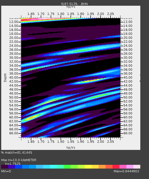
| Estimated Moho Depth: |
10.0 km |
| Estimated Crust Vp/Vs: |
1.75 |
| Assumed Crust Vp: |
6.207 km/s |
| Estimated Crust Vs: |
3.542 km/s |
| Estimated Crust Poisson's Ratio: |
0.26 |
|
| Radial Match: |
81.41445 % |
| Radial Bump: |
400 |
| Transverse Match: |
61.543835 % |
| Transverse Bump: |
400 |
| SOD ConfigId: |
6273 |
| Insert Time: |
2010-03-08 18:10:51.864 +0000 |
| GWidth: |
2.5 |
| Max Bumps: |
400 |
| Tol: |
0.001 |
|

Signal To Noise
| Channel | StoN | STA | LTA |
| XL:S125: :BHN:19970902T12:21:02.794989Z | 18.67763 | 1.2225075E-6 | 6.545304E-8 |
| XL:S125: :BHE:19970902T12:21:02.794989Z | 6.393547 | 9.044371E-7 | 1.4146093E-7 |
| XL:S125: :BHZ:19970902T12:21:02.794989Z | 32.336956 | 3.036589E-6 | 9.39046E-8 |
| Arrivals |
| Ps | 1.3 SECOND |
| PpPs | 4.2 SECOND |
| PsPs/PpSs | 5.5 SECOND |


