You are here: Home > Network List > XL97 - Deep Probe (Archean-Proterozoic) Stations List
> Station S126 Desarado Road > Earthquake Result Viewer
S126 Desarado Road - Earthquake Result Viewer
| Earthquake location: |
South Of Fiji Islands |
| Earthquake latitude/longitude: |
-25.5/178.3 |
| Earthquake time(UTC): |
1997/08/26 (238) 15:22:09 GMT |
| Earthquake Depth: |
610 km |
| Earthquake Magnitude: |
5.5 MB, 5.7 UNKNOWN |
| Earthquake Catalog/Contributor: |
WHDF/NEIC |
|
| Network: |
XL Deep Probe (Archean-Proterozoic) |
| Station: |
S126 Desarado Road |
| Lat/Lon: |
40.19 N/108.73 W |
| Elevation: |
1761 m |
|
| Distance: |
94.1 deg |
| Az: |
47.244 deg |
| Baz: |
240.01 deg |
| Ray Param: |
0.040512998 |
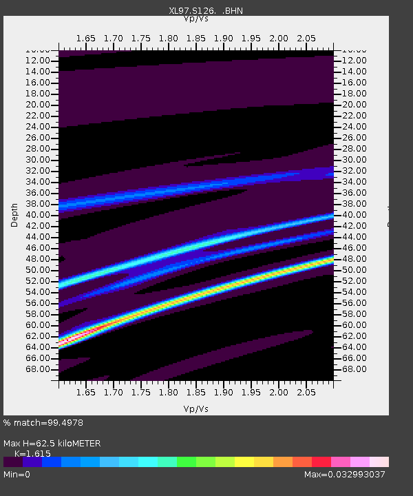
| Estimated Moho Depth: |
62.5 km |
| Estimated Crust Vp/Vs: |
1.62 |
| Assumed Crust Vp: |
6.207 km/s |
| Estimated Crust Vs: |
3.843 km/s |
| Estimated Crust Poisson's Ratio: |
0.19 |
|
| Radial Match: |
99.4978 % |
| Radial Bump: |
45 |
| Transverse Match: |
97.5416 % |
| Transverse Bump: |
179 |
| SOD ConfigId: |
4480 |
| Insert Time: |
2010-03-08 18:11:01.985 +0000 |
| GWidth: |
2.5 |
| Max Bumps: |
400 |
| Tol: |
0.001 |
|

Signal To Noise
| Channel | StoN | STA | LTA |
| XL:S126: :BHN:19970826T15:33:52.386011Z | 0.8123664 | 6.8578463E-9 | 8.4418135E-9 |
| XL:S126: :BHE:19970826T15:33:52.386011Z | 0.87699354 | 3.4770402E-9 | 3.964727E-9 |
| XL:S126: :BHZ:19970826T15:33:52.386011Z | 0.9222746 | 3.6966423E-9 | 4.00818E-9 |
| Arrivals |
| Ps | 6.3 SECOND |
| PpPs | 26 SECOND |
| PsPs/PpSs | 32 SECOND |


