
Station XL S126 - Desarado Road
Network: XL97 - Deep Probe (Archean-Proterozoic)
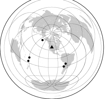
Nearby stations (2 deg radius)
| Station | Name | (Lat, Lon) | Start / End | Elevation |
| S126 | Desarado Road | (40.19, -108.73) | 1997-05-05 / 1997-12-31 | 1761 m |
| Crust2 Type: | Q4,orogen/43km no ice, Tethian Belt, 5 km seds. |
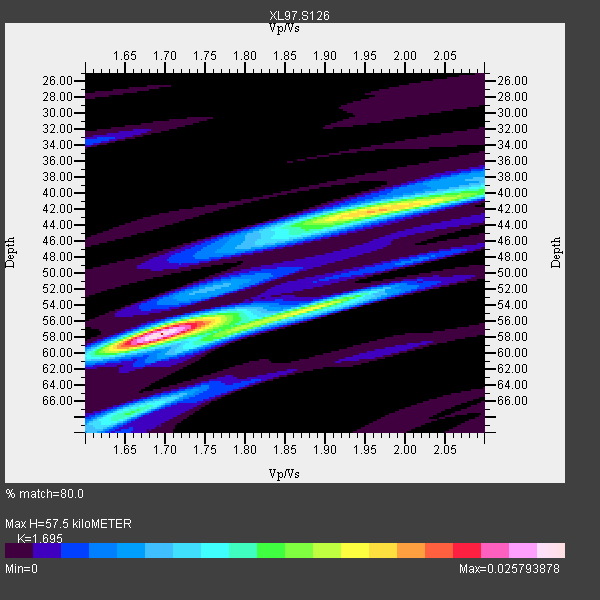
| Thickness Estimate: | 58 km |
| Thickness StdDev: | 5.6 km |
| Vp/Vs Estimate: | 1.70 |
| Vp/Vs StdDev: | 0.11 |
| Vs Estimate: | 3.662 km/s |
| Poisson's Ratio: | 0.23 |
| Peak Value: | 0.03 |
| Assumed Vp: | 6.207 km/s |
| Ps Weight: | 0.33333334 |
| PpPs Weight: | 0.33333334 |
| PsPs Weight: | 0.33333328 |
| Residual Complexity: | 0.697 |
| Nearby stations H: | +- |
| (2.0 deg) Vp/Vs: | +- |
3 with match > 90% ( 21.428572 %) and 6 with match > 80% ( 42.857143 %) out of 14.
Download stack as xyz text file.
Azimuth Distribution of Events:
Prior Results for this Station
| Study | Thickness | Vp/Vs | Vp | Vs | Poissons Ratio | Extra |
| EARS | 58 km | 1.70 | 6.207 km/s | 3.662 km/s | 0.23 | |
| Crust2.0 | 43 km | 1.76 | 6.207 km/s | 3.535 km/s | 0.26 | Q4,orogen/43km no ice, Tethian Belt, 5 km seds. |
| Global Maxima | 58 km | 1.70 | 6.207 km/s | 3.662 km/s | 0.23 | amp=0.025793878 |
| Local Maxima 1 | 42 km | 1.98 | 6.207 km/s | 3.143 km/s | 0.33 | amp=0.017439378 |
| Local Maxima 2 | 57 km | 1.80 | 6.207 km/s | 3.453 km/s | 0.28 | amp=0.013570366 |
| Local Maxima 3 | 68 km | 1.65 | 6.207 km/s | 3.756 km/s | 0.21 | amp=0.010063421 |
| Local Maxima 4 | 54 km | 1.89 | 6.207 km/s | 3.284 km/s | 0.31 | amp=0.0075365035 |
| Predicted Arrivals for vertical incidence (zero ray parameter) | |
| Ps | 6.44 SECOND |
| PpPs | 24.97 SECOND |
| PsPs/PpSs | 31.40 SECOND |
Events Processed for this Station
Download zip of receiver functions as SAC
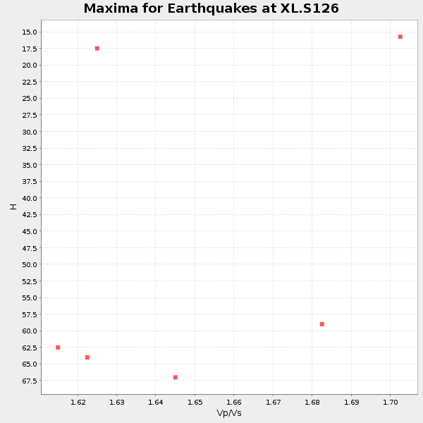
Plot maxima for each earthquake.
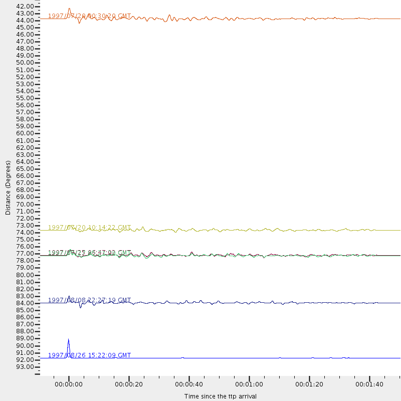
Events Used in the Stack
(6 events)| Radial Match | Distance | Baz | FERegion | Time | Lat/Lon | Depth | Magnitude |
| 99.4978 | 94.1 deg | 240.01 deg | South Of Fiji Islands | 1997/08/26 15:22:09 GMT | (-25.5, 178.3) | 610 km | 5.5 MB, 5.7 UNKNOWN |
| 90.93577 | 85.6 deg | 245.658 deg | Fiji Islands Region | 1997/08/08 22:27:19 GMT | (-15.5, -179.1) | 10 km | 5.7 MB, 6.6 MS, 6.6 UNKNOWN, 6.4 MW |
| 90.69621 | 78.2 deg | 148.069 deg | Near Coast Of Central Chile | 1997/07/27 05:21:29 GMT | (-30.5, -71.9) | 33 km | 5.6 MB, 5.8 MS, 6.3 UNKNOWN, 6.2 MW |
| 89.85699 | 41.3 deg | 307.687 deg | Fox Islands, Aleutian Islands | 1997/07/20 00:30:20 GMT | (52.6, -167.5) | 14 km | 5.6 MB, 5.9 MS, 6.2 UNKNOWN, 6.2 MW |
| 88.12587 | 78.2 deg | 148.077 deg | Near Coast Of Central Chile | 1997/07/25 06:47:02 GMT | (-30.5, -71.9) | 33 km | 5.6 MB, 5.5 MS, 6.3 UNKNOWN |
| 85.58403 | 74.2 deg | 139.756 deg | Jujuy Province, Argentina | 1997/07/20 10:14:22 GMT | (-23.0, -66.3) | 256 km | 5.7 MB, 6.1 UNKNOWN, 5.7 ME |
Losers
(8 events)| Radial Match | Distance | Baz | FERegion | Time | Lat/Lon | Depth | Magnitude | Reason |
| 76.55691 | 77.2 deg | 147.335 deg | Near Coast Of Central Chile | 1997/07/19 12:22:57 GMT | (-29.3, -71.7) | 26 km | 5.8 MB, 5.5 MS, 5.9 UNKNOWN, 5.8 MW | |
| 71.638695 | 72.8 deg | 312.35 deg | Kuril Islands | 1997/07/14 16:09:35 GMT | (43.2, 146.4) | 33 km | 5.9 MB, 5.8 MS, 6.1 UNKNOWN, 5.8 ME | |
| 68.90314 | 89.0 deg | 298.617 deg | Volcano Islands, Japan Region | 1997/07/28 06:46:55 GMT | (22.4, 142.7) | 33 km | 5.7 MB, 5.8 MS, 5.9 UNKNOWN, 5.9 MW | |
| 65.19452 | 94.1 deg | 255.75 deg | Vanuatu Islands | 1997/08/17 20:11:10 GMT | (-13.6, 167.4) | 26 km | 5.4 MB, 6.1 MS, 6.1 UNKNOWN, 6.0 MW | |
| 55.59179 | 81.4 deg | 241.884 deg | Tonga Islands | 1997/05/27 08:00:29 GMT | (-15.2, -173.3) | 14 km | 5.6 MB, 6.3 MS, 6.4 UNKNOWN, 5.7 ME | |
| 49.495502 | 97.6 deg | 195.566 deg | Pacific-Antarctic Ridge | 1997/05/27 06:10:31 GMT | (-54.9, -136.2) | 10 km | 5.9 MS, 5.3 MB, 6.1 UNKNOWN, 6.0 MW | |
| 46.639156 | 91.2 deg | 292.483 deg | Mariana Islands | 1997/05/27 15:09:03 GMT | (16.3, 145.4) | 536 km | 5.5 MB, 5.6 UNKNOWN, 5.6 MW | |
| 44.232513 | 76.3 deg | 144.55 deg | Northern Chile | 1997/05/17 02:10:18 GMT | (-27.2, -69.5) | 106 km | 5.5 MB, 5.6 UNKNOWN, 5.5 MW |
