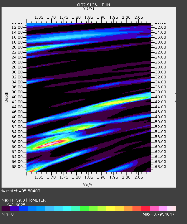
S126 Desarado Road - Earthquake Result Viewer

Earthquake location: Jujuy Province, Argentina
Earthquake latitude/longitude: -23.0/-66.3
Earthquake time(UTC): 1997/07/20 (201) 10:14:22 GMT
Earthquake Depth: 256 km
Earthquake Magnitude: 5.7 MB, 6.1 UNKNOWN, 5.7 ME
Earthquake Catalog/Contributor: WHDF/NEIC
Network: XL Deep Probe (Archean-Proterozoic)
Station: S126 Desarado Road
Lat/Lon: 40.19 N/108.73 W
Elevation: 1761 m
Distance: 74.2 deg
Az: 327.519 deg
Baz: 139.756 deg
Ray Param: 0.05176325
Estimated Moho Depth: 59.0 km
Estimated Crust Vp/Vs: 1.68
Assumed Crust Vp: 6.207 km/s
Estimated Crust Vs: 3.689 km/s
Estimated Crust Poisson's Ratio: 0.23
Radial Match: 85.58403 %
Radial Bump: 400
Transverse Match: 76.639465 %
Transverse Bump: 400
SOD ConfigId: 6273
Insert Time: 2010-03-08 18:11:05.249 +0000
GWidth: 2.5
Max Bumps: 400
Tol: 0.001

Signal To Noise

ChannelStoNSTALTA
XL:S126: :BHN:19970720T10:25:00.83302Z6.1779883.4823665E-75.6367323E-8
XL:S126: :BHE:19970720T10:25:00.83302Z4.7295454.1892193E-78.857552E-8
XL:S126: :BHZ:19970720T10:25:00.83302Z24.5650711.9468937E-67.9254555E-8
Arrivals
Ps6.7 SECOND
PpPs25 SECOND
PsPs/PpSs31 SECOND